Caher West Top
| Caher West Top | |
|---|---|
|
Caher West Top from Caher | |
| Highest point | |
| Elevation | 973.4 m (3,194 ft) [1] |
| Listing | Furth |
| Coordinates | 51°58′39″N 9°43′49″W / 51.9776°N 9.7303°WCoordinates: 51°58′39″N 9°43′49″W / 51.9776°N 9.7303°W |
| Geography | |
 Caher West Top | |
| Parent range | MacGillycuddy's Reeks |
_-_geograph.org.uk_-_1434483.jpg)
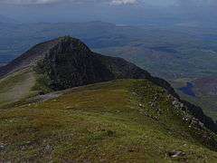
Caher West Top (right) beyond the main Caher peak (middle)
Caher West Top is the fifth-highest mountain peak in Ireland, at 973.4 metres (3,194 ft).[2]
Geography
The mountain is located about 500 metres west of Caher East Top and is part of the MacGillycuddy's Reeks of County Kerry. Its grid reference is V789840.[1] Other nearby peaks include: Skregmore, The Bones, Cnoc Iochtair, Carrauntoohil and Beenkeragh.[3]
Caher West Top is counted by the Scottish Mountaineering Club as a Furth (a 3,000-footer outside Scotland),[4] which is why it is sometimes referred to as one of the Irish Munros.
See also
References
- 1 2 Caher West Top at mountainviews.ie. Accessed on 5 Feb 2013.
- ↑ Caher (West Top) at peakery.com. Accessed on 5 Feb 2013.
- ↑ Caher West Top maps at www.themountainguide.co.uk. Accessed on 5 Feb 2013.
- ↑ Mountains – Key Facts. The Munros, Corbetts, Grahams, Donalds & Furths at www.smc.org.uk. Accessed on 5 Feb 2013.
This article is issued from Wikipedia - version of the 9/24/2016. The text is available under the Creative Commons Attribution/Share Alike but additional terms may apply for the media files.