Cầu Giấy District
| Cau Giay District Quận Cầu Giấy | |
|---|---|
| Urban district | |
|
| |
| Country |
|
| Province | Hanoi |
| Number of wards | 8 |
| Area | |
| • Total | 12.04 km2 (4.65 sq mi) |
| Population (2001) | |
| • Total | 142,800 |
| Time zone | ICT (UTC+7) |
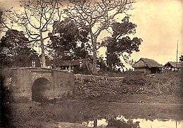
The historic Paper Bridge
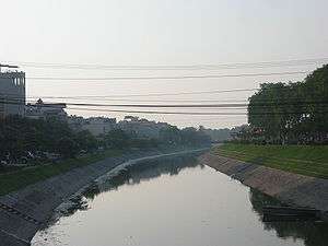
Cầu Giấy (lit. Paper Bridge) is an urban district of Hanoi, the capital city of Vietnam. The district is named after the historic bridge where the famous 19th-century Battle of Cầu Giấy (Paper Bridge) was fought.
Many urban areas are located in Cau Giay. Among them, Trung Hoà - Nhân Chính is emerging as the new city's commercial center. It lies partly in the southern part of the district (Trung Hoà ward). The massive Keangnam Hanoi Landmark Tower, the tallest building in Vietnam, is also located in this area.
Administrative divisions
The district is divided into 8 wards (phường):
- Nghĩa Đô
- Quan Hoa
- Dịch Vọng
- Dịch Vọng Hậu
- Trung Hoà
- Nghĩa Tân
- Mai Dịch
- Yên Hòa
Major streets
- Đường Cầu Giấy (Cau Giay Street) is 1.8 km long, running from the intersection of Kim Mã Street and La Thành Street northwestward across the Tô Lịch River to an intersection with Nguyễn Phong Sắc Street. The street continues westward under the name Xuân Thủy Street and eventually becomes Route 32. Cầu Giấy Street is part of old Route 32. It used to be in Từ Liêm District and run through farmland as part of the route to Sơn Tây. Now it is in Ngọc Khánh Ward of Ba Đình District and Quan Hoa Ward of Cầu Giấy District. In January 1998 it received its current name in honor of the former town of Cầu Giấy which also gave its name to the district.[1][2]
- Đường Chùa Hà
- Đường Hoàng Đạo Thúy
- Đường Hoàng Minh Giám
- Đường Hoàng Quốc Việt
- Đường Hồ Tùng Mậu
- Đường Lê Đức Thọ
- Đường Nguyễn Khánh Toàn
- Đường Nguyễn Phong Sắc
- Đường Nguyễn Văn Huyên
- Đường Phạm Hùng
- Đường Phạm Văn Đồng
- Đường Trần Cung (Tran Cung Street) runs 1.6 km from Phạm Văn Đồng Street southeastward past Hospital E to an intersection with Hoàng Quốc Việt Street. At that point the road continues south with the new name of Nguyễn Phong Sắc Street. Trần Cung Street was formerly part of old Route 69 in undeveloped land in Từ Liêm District. In August 2005, it received the name Trần Cung Street in honor of Trần Cung (1899 - 1995), politician and judge.[3]
- Đường Trần Đăng Ninh (Tran Dang Ninh Street) is 700 m. long, running north from Cầu Giấy Street through Dịch Vọng village to a traffic circle at Nguyễn Khánh Toàn Street and then northwest to an intersection with Nguyễn Phong Sắc Street. It was formerly in Dịch Vọng village of Từ Liêm District, but is now in Dịch Vọng Ward of Cầu Giấy District. In July 1999 it was named after Trần Đăng Ninh (1910 - 1955), soldier and politician.[3]
- Đường Trần Duy Hưng (Tran Duy Hung Street) is 1.6 km long, running from the bridge over the Tô Lịch River where the road continues north as Nguyễn Chí Thanh Street southwestward to an intersection with Phạm Hùng Street. The road continues westward as the Đại lộ Thăng Long Expreesway. In 1998 Trần Duy Hưng Street was the first double-lane road opened to Hoà Lạc. Formerly it was in Trung Hoà village of Từ Liêm District, but now is in Trung Hoà Ward of Cầu Giấy District, part of Trung Hoà–Nhân Chính. In January 1999 it was named Trần Duy Hưng Street after Trần Duy Hưng (1912 -1988), a doctor and politician.[3]
- Đường Trần Quốc Hoàn (Tran Quoc Hoan Street) is 1 km long, running east from Phạm Văn Đồng Street to an intersection with Nguyễn Phong Sắc Street. After crossing Nguyễn Phong Sắc Street the road continues east as Tô Hiệu Street. It was formerly in Dịch Vọng village of Từ Liêm District, but is now in Dịch Vọng Ward of Cầu Giấy District. In February 2003 it was named after former Security Minister Trần Quốc Hoàn.[4]
- Đường Trung Yên (Trung Yen Street)
- Đường Xuân Thủy (Xuan Thuy Street)[5]
- Phố Dương Quảng Hàm
- Phố Hoàng Sâm
- Phố Mai Dịch
- Phố Nghĩa Tân
- Phố Nguyễn Khả Trạc
- Phố Nguyễn Thị Thập
- Phố Phan Văn Trường
- Phố Phạm Thận Duật
- Phố Phạm Tuấn Tài
- Phố Phùng Chí Kiên
- Phố Tô Hiệu
- Phố Trần Bình
- Phố Trần Duy Hưng
- Phố Trần Quý Kiên
- Phố Trần Tử Bình
- Phố Trung Kính
- Phố Yên Hòa
Education
Korean International School in Hanoi, a Korean international school, is in the district.
Notes
- ↑ "Các đường phố Hà Nội theo vần C (The streets of Hanoi alphabetically C)" (in Vietnamese). Báo điện tử Đảng Cộng sản Việt Nam (Communist Party of Vietnam). 25 February 2010. Archived from the original on 29 September 2013.
- ↑ "Đường: Đường Cầu Giấy, Quận Cầu Giấy, Hà Nội (Street: Cầu Giấy Street, Cầu Giấy District. Hanoi)" (in Vietnamese). Diachiso.vn (geographic information). Archived from the original on 26 June 2012.
- 1 2 3 "Các đường phố Hà Nội theo vần T (tiếp theo) (The streets of Hanoi alphabetically T (continued))" (in Vietnamese). Báo điện tử Đảng Cộng sản Việt Nam (Communist Party of Vietnam). 17 March 2010.
- ↑ "Các đường phố Hà Nội theo vần T (tiếp theo) (The streets of Hanoi alphabetically T (continued))" (in Vietnamese). Báo điện tử Đảng Cộng sản Việt Nam (Communist Party of Vietnam). 18 March 2010. Archived from the original on 2013-09-28.
- ↑ "Đường: Đường Xuân Thủy, Quận Cầu Giấy, Hà Nội (Street: Xuân Thủy Street, Cầu Giấy District. Hanoi)" (in Vietnamese). Diachiso.vn (geographic information). Archived from the original on 17 September 2012.
| Urban districts |
|
|---|---|
| Provincial towns | |
| Rural districts | |
This article is issued from Wikipedia - version of the 12/4/2016. The text is available under the Creative Commons Attribution/Share Alike but additional terms may apply for the media files.