Cítoliby
| Cítoliby | |||
|---|---|---|---|
| Městys | |||
 | |||
| |||
 Cítoliby | |||
| Coordinates: 50°20′4″N 13°48′34″E / 50.33444°N 13.80944°ECoordinates: 50°20′4″N 13°48′34″E / 50.33444°N 13.80944°E | |||
| Country |
| ||
| Region | Ústí nad Labem | ||
| District | Louny | ||
| Area | |||
| • Total | 6.82 km2 (2.63 sq mi) | ||
| Elevation | 236 m (774 ft) | ||
| Population (2006) | |||
| • Total | 1,000 | ||
| • Density | 150/km2 (380/sq mi) | ||
| Postal code | 439 02 | ||
| Website | http://www.obec-citoliby.cz/ | ||

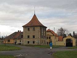
Cítoliby (German: Zittolib) is a small town (městys) in Louny District in the Ústí nad Labem Region of the Czech Republic.
The town covers an area of 6.82 square kilometres (2.63 sq mi), and has a population of 1,000 (as at 2 October 2006).
Cítoliby lies approximately 3 kilometres (2 mi) south of Louny, 40 km (25 mi) south-west of Ústí nad Labem, and 52 km (32 mi) north-west of Prague.
References
| Wikimedia Commons has media related to Cítoliby. |
This article is issued from Wikipedia - version of the 12/4/2016. The text is available under the Creative Commons Attribution/Share Alike but additional terms may apply for the media files.