Burnham Market
| Burnham Market | |
 Burnham Market |
|
| Area | 18.43 km2 (7.12 sq mi) |
|---|---|
| Population | 877 (2011) |
| – density | 48/km2 (120/sq mi) |
| OS grid reference | TF834422 |
| Civil parish | Burnham Market |
| District | King's Lynn and West Norfolk |
| Shire county | Norfolk |
| Region | East |
| Country | England |
| Sovereign state | United Kingdom |
| Post town | KING'S LYNN |
| Postcode district | PE31 |
| Police | Norfolk |
| Fire | Norfolk |
| Ambulance | East of England |
| EU Parliament | East of England |
Coordinates: 52°56′45″N 0°43′41″E / 52.94584°N 0.72815°E

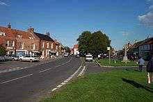

Burnham Market is a village and civil parish near the north coast of Norfolk, England. Burnham Market is one of the Burnhams, a group of adjacent villages in North Norfolk. It is the result of the merger of three of the original Burnham villages, namely Burnham Sutton, Burnham Ulph and Burnham Westgate.
Burnham Market lies approximately 1 mile (2 km) inland, some 5 miles (8 km) west of Wells-next-the-Sea, 12 miles (19 km) east of Hunstanton and 10 miles (16 km) north of Fakenham. The smaller villages of Burnham Deepdale and Burnham Norton are within 2 miles (3 km) to the west and north of Burnham Market, whilst Burnham Overy and Burnham Thorpe are a similar distance to the east. North Creake is some 4 miles (6 km) to the south. The larger town of King's Lynn is 20 miles (30 km) to the south-west, whilst the city of Norwich is 30 miles (50 km) to the south-east.[1]
The civil parish has an area of 18.43 km2 and in the 2001 census had a population of 948 in 496 households, decreasing to 877 at the 2011 Census.[2] For the purposes of local government, the parish falls within the district of King's Lynn and West Norfolk.[3]
Burnham Market is close to the mouth of the River Burn and the name Burnham probably derives from this. However another theory is that the town was a centre for the amber trade. As the name implies, historically Burnham had a market and was therefore considered a town, however that market was discontinued several years before 1854.[4] Today Burnham Market is more normally considered a village, albeit one slightly larger and considerably busier than its immediate neighbours.

In recent times Burnham Market has attracted a significant number of second-home owners, mostly affluent residents of London, and in consequence acquired a somewhat metropolitan atmosphere. Long term local residents often refer to the village as Chelsea-on-sea, after the up-market London district of Chelsea. One of the factors driving this movement is the presence of the up-market pub and restaurant, the Hoste Arms, named after Captain William Hoste or his family.
The village was served by a railway until 1952, connected to the east with Wells-next-the-Sea and Holkham, and to the west with Hunstanton.
Governance
Burnham is the name of the electoral ward which covers all the Norfolk Burnhams and surrounding areas. The total population at the 2011 census was 1,714.[5]
Burnham Westgate Hall
Burnham Westgate Hall is a Grade II* listed Georgian country house, built 1783-1785 by Sir John Soane, for Thomas Pitt, 1st Baron Camelford.[6] It was a remodelling of the original Polstede Hall, was built in the 1750s by Matthew Brettingham for Pitt’s father-in-law Pinckney Wilkinson, MP for Old Sarum. In 1783, Wilkinson gave the house to his daughter, Anne, on her marriage to Pitt.
In 1808, the Hall was purchased by Sir Mordaunt Martin.
In 1933, the house was passed to the Royal British Legion. After World War II, it was used as an elderly people's home until 1990. Most recently it has been the home of Baroness Rawlings.[7]
Places of Worship
The village has two Anglican parish churches. The largest is St. Mary's at the west end of the marketplace (Westgate church), while All Saints' Church at the eastern end of the village (Sutton-cum-Ulph because it incorporated the parish and some of the stone of St. Ethelbert's at Burnham Sutton, some four hundred yards to the south, when Horatio Nelson's father Edmund was rector of both churches in the 1760s and 1770s). A third building close to Burnham Market is St Margaret's. This is located in the neighbouring parish of Burnham Norton. Controversially (to the residents of Burnham Norton at least), it was incorporated with St Mary's (Westgate) to form the new ecclesiastical parish of Burnham Market in 2012. The former churches, with the parishes of Burnham Overy and Burnham Thorpe (birthplace of Nelson), form the single benefice, the Burnhams Benefice.[8]
There are two other places of worship in the village: the Roman Catholic church, St Henry Walpole, and a Methodist church. The old Gospel Hall was put up for sale in 2015.
References
- ↑ Ordnance Survey (2002). OS Explorer Map 251 - Norfolk Coast Central. ISBN 0-319-21887-2.
- ↑ "Parish population 2011". Retrieved 26 August 2015.
- ↑ Office for National Statistics & Norfolk County Council (2001). Census population and household counts for unparished urban areas and all parishes. Retrieved October 18, 2005.
- ↑ Francis White (1854). Francis White's History, Gazetteer and Directory of Norfolk - Burnham Westgate (or Burnham Market). Retrieved October 18, 2005.
- ↑ "Burnham ward population 2011". Retrieved 27 August 2011.
- ↑ "Burnham Westgate Hall" (PDF).
- ↑ Churchill, Penny (2011), An exceptional country estate in Norfolk
- ↑ Burnhams Benefice Parish. Churches and Church Locations. Retrieved March 07, 2012
External links
| Wikivoyage has a travel guide for Burnham Market. |
| Wikimedia Commons has media related to Burnham Market. |
- Map sources for Burnham Market
- Information from Genuki Norfolk on Burnham Market.