Bagthorpe with Barmer
| Bagthorpe with Barmer | |
 Bagthorpe with Barmer |
|
| Area | 9.05 km2 (3.49 sq mi) |
|---|---|
| OS grid reference | TF804330 |
| Civil parish | Bagthorpe with Barmer |
| District | King's Lynn and West Norfolk |
| Shire county | Norfolk |
| Region | East |
| Country | England |
| Sovereign state | United Kingdom |
| Post town | KING'S LYNN |
| Postcode district | PE31 |
| Police | Norfolk |
| Fire | Norfolk |
| Ambulance | East of England |
| EU Parliament | East of England |
Coordinates: 52°51′51″N 0°40′42″E / 52.86424°N 0.67845°E
Bagthorpe with Barmer is a civil parish in the English county of Norfolk. The parish includes the hamlets of Bagthorpe and Barmer, and is situated some 15 km west of Fakenham and 20 km north east of King's Lynn.[1] As the population of the civil parish remained less than 100 at the 2011 Census it was included in the civil parish of Stanhoe.
The civil parish has an area of 9.05 km2 and in the 2001 census had a population of 53 in 22 households. For the purposes of local government, the parish falls within the district of King's Lynn and West Norfolk.[2]
Church
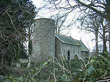
Barmer All Saints is one of 124 existing round-tower churches in Norfolk. The church was associated with the local land owning Kerslake family and the family coat of arms can be seen above the door to the church.
The Kerslake family owned much of the surrounding land as well as the family manor house. The house no longer exists but part of the estate is incorporated into the farm nearby which takes its name, Manor Farm, from the house which once stood there.
Several of the Kerslake family are buried in the churchyard and their headstones can be seen under the foliage.
The Kerslake family originate from the south west of England where the family owned shipyards building ships for the Royal Navy. Due to the considerable amount of work undertaken for the Admiralty during the 18th century, the family became wealthy and also a government creditor. As was common at the time, it is believed that the family were awarded a large plot of land and manorial rights in part payment of government debt.
Although manorialism was a feudal society, and therefore a medieval, practice; governments later in British history and especially during the Georgian era would grant land and in some cases titles to certain families in lieu of payment or in recognition of services rendered.
References
- ↑ Ordnance Survey (2002). "Norfolk Coast West". OS Explorer Map. 250. ISBN 0-319-21886-4.
- ↑ "Census population and household counts for unparished urban areas and all parishes" (XLS). Office for National Statistics & Norfolk County Council. 2001. Retrieved 2005-12-02.
External links
| Wikimedia Commons has media related to Bagthorpe with Barmer. |
- Information from Genuki Norfolk on Bagthorpe.
- Information from Genuki Norfolk on Barmer.
- Website with photos of Barmer All Saints, a Round-tower church
- Bagthorpe in the Domesday Book
- Barmer in the Domesday Book