Garway

Garway (Llanwrfwy) is a civil parish in south-west Herefordshire, England. The population of the civil parish was at the 2011 census 430.[1] It is set on a hillside above the River Monnow about 10 km northwest of Monmouth. It is a sparsely populated area, mainly agricultural in nature. There are several small centres of population: Garway, Broad Oak, The Turning and Garway Hill.
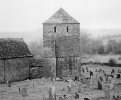
Garway church
The church is on the western edge of the parish and is dedicated to Saint Michael.
The earliest record of a monastery on the site is in the seventh century, but it is with the arrival of the Knights Templar in 1180 that the history of the church at Garway becomes clearer. The Knights Templar built a hut in honour of the Holy Sepulchre in Jerusalem.

The excavated foundations of part of the round church (unearthed in 1927) can be seen clearly on the north side of the present church, and the original carved chancel arch, heavily decorated and in the Norman style, survives. Most of the current church, which is no longer round, is probably 13th century including the massive defensible tower which was once separate from the main church building. There are numerous carvings both inside and outside the building including a green man, a sword believed to be Templar, a fish and a snake.

Garway church is an important part of the community and in addition to regular services it is used for many other events.
The dovecote, on private land near Garway Church, has an inscription dating it to 1326 and has been described as probably the finest dovecote in England.[2] It was featured in the fictional BBC1 action/drama series Bonekickers on 8 July 2008.
Garway is featured in "The Fabric of Sin", a novel written by Phil Rickman, and in Bernard Knight's chapter in King Arthur's Bones by The Medieval Murderers.
References
- ↑ "Civil Parish population 2011". Retrieved 30 October 2015.
- ↑ "Dovecote, Church House Farm, Garway". Herefordshire Through Time. Herefordshire Council. Retrieved 2011-01-02.
External links
| Wikimedia Commons has media related to Garway. |
- Church and community site including Garway Church, includes location map
- Britannia, shows plan of church
- Photograph of Garway Church
- Floorplan of the Garway Complex
- Historic Herefordshire Online
- Map sources for Garway
- Garway Folk Weekend (June 4-6 2010) site
Coordinates: 51°53′51″N 2°47′42″W / 51.89746°N 2.79491°W