Bracken Peak
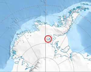
Bracken Peak (77°51′S 85°24′W / 77.850°S 85.400°WCoordinates: 77°51′S 85°24′W / 77.850°S 85.400°W) is a peak, 1,240 metres (4,070 ft) high, standing in Sostra Heights south of the terminus of Newcomer Glacier and 3 miles (5 km) northeast of Mount Malone, on the east side of the Sentinel Range, Ellsworth Mountains. It surmounts Anchialus Glacier to the west and Vit Ice Piedmont to the east.
It was first mapped by the United States Geological Survey from surveys and from air photos taken by U.S. Navy Squadron VX-6 on photographic flights of December 14–15, 1959, and named by the Advisory Committee on Antarctic Names for H.J. Bracken, plane captain of the airplane on these flights.[1]
References
- ↑ "Bracken Peak". Geographic Names Information System. United States Geological Survey. Retrieved 2011-08-12.
![]() This article incorporates public domain material from the United States Geological Survey document "Bracken Peak" (content from the Geographic Names Information System).
This article incorporates public domain material from the United States Geological Survey document "Bracken Peak" (content from the Geographic Names Information System).