Boundary Bay
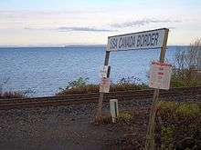
Boundary Bay is situated on the Pacific coast of North America on the Canada–United States border between the Canadian province of British Columbia and the U.S. state of Washington.
To the north and west, Boundary Bay is bounded by the municipality of Delta.

Point Roberts, Washington, lies to the southwest. The communities of Beach Grove and Boundary Bay (both situated within Delta) are to the west, while rural East Delta is to the north. Along the eastern shore are Crescent Beach and Ocean Park in the City of Surrey; further south-east, White Rock and the Semiahmoo First Nation's reserve in BC and Blaine in Washington State.
The eastern section of Boundary Bay, straddling the US/Canada border and adjacent to White Rock and Blaine is known as Semiahmoo Bay; Blaine's Drayton Harbor opens into it. The northern tip of Boundary Bay is known as Mud Bay.
The main rivers flowing into the bay are the Nicomekl and Serpentine Rivers falling into Mud Bay, the Campbell River falling into Semiahmoo Bay, and California Creek and Dakota Creek falling into Drayton Harbor.

It is an important stop for birds migrating along the Pacific Flyway, particularly for western sandpiper and dunlin, and has been designated a Hemisphere Reserve by the Western Hemisphere Shorebird Reserve Network and a Canadian Important Bird Area. The mudflats, extensive eel grass beds and salt marshes support a rich population of marine invertebrates which are an important source of energy for migrating shorebirds. During migration times the bird count in the bay may exceed 100,000.
The area is also used for recreational boating and includes park area and beaches. Pollution and industrial activity in the area pose potential threats to wildlife. The Boundary Bay Airport, on its north flank, is used by small aircraft and has been the setting for various film shoots.
See also
External links
| Wikimedia Commons has media related to Boundary Bay. |
- Birds on the Bay
- Film footage of Centennial Beach in 1958
- A Nature Guide to Boundary Bay Author's Site.
- A Nature Guide to Boundary Bay Photographer's Site.
Coordinates: 49°N 123°W / 49°N 123°W
Surrounding geography
 |
Delta, British Columbia | Delta, British Columbia | Surrey, British Columbia | |
| Tsawwassen | |
South Surrey, White Rock | ||
| ||||
| | ||||
| Point Roberts, Washington | Strait of Georgia & Washington (state) | Semiahmoo Bay, Blaine, Washington |