Pothong River
| Pothong River | |
| Chosŏn'gŭl | 보통강 |
|---|---|
| Hancha | 普通江 |
| Revised Romanization | Botong-gang |
| McCune–Reischauer | Pot'ong-gang |
The Pothong River (Pot'ong River, Potonggang) is a river in North Korea. It flows through the capital Pyongyang and is a tributary of the Taedong River.[1]
There are several bridges across the river in Pyongyang, including one at its mouth called the "Pothong Bridge"; however, the largest is the one known as "Ansan Bridge", 39°02′02″N 125°42′15″E / 39.03389°N 125.70417°E, which supports the main east-west divided highway.[2][3]
Prior to 1946, the arable land west of Pyongyang alongside the river (the flood plain), down to where it entered the Taedong River was subject to annual flooding. This area was known as Tosongrang.[4] The farmers there annually rebuilt their homes after the floods subsided, so the construction was, perforce, of a temporary nature, huts and even pit-houses.[5] In 1946 the river was channelized through Tosongrang as the "Pothong River Improvement Project".[1][4] Tosongrang is now part of Pyongyang.
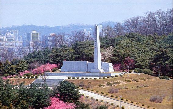
In 1971, in a park on Mount Bonghwa,[6] a hill on the left (east) bank of the river, the government erected a monument for the "Pothong River Improvement Project", 39°02′38″N 125°42′34″E / 39.04389°N 125.70944°E.[4][7] It commemorates Kim Il-sung's 1945 visit to Tosongrang and the 1946 channelization.
In 1976 the North Korean postal service (DPRK) issued a stamp commemorating Kim Il-sung's 1945 visit to Tosongrang.[8] In 1998, they issued a stamp souvenir sheet showing Kim Il-sung breaking ground for the construction of the channelization project.[9]
Notes and references
- 1 2 Corfield, Justin (2014). Historical Dictionary of Pyongyang. London: Anthem Press. p. 167. ISBN 978-1-78308-341-1.
- ↑ The Ansan Bridge appears on a 1990 stamp, Scott #2891, label in that catalogue as "Pothong Bridge" - Scott (2008) "Korea, Democratic People’s Republic" Scott 2009 Standard Postage Stamp Catalogue Volume 4 (165th edition) Scott Publishing Co., Sidney, Ohio, page 303. ISBN 978-0-89487-420-8
- ↑ See map at http://www.pyongyang-metro.com/pystrtmp.jpeg
- 1 2 3 "Ufergebiet des Flusses Pothonggang" [The Banks of the Potong River] (in German). Nordkorea-Information. Archived from the original on 28 March 2016.
- ↑ Some authors referred to it as a slum. Springer, Chris (2003). Pyongyang: The Hidden History of the North Korean Capital. Budapest: Entente Bt. ISBN 978-963-00-8104-7.; Han, Myŏng-ho (1994). Kim Il Sung: The Great Man of the Century (PDF). Pyongyang: Foreign Languages Publishing House. OCLC 30886237.
- ↑ The park is sometimes known as "Potong River Pleasure Ground".
- ↑ "Pothong River Improvement Project". Geoview (Lutz Harder).
- ↑ Scott #1533 - Scott (2008), page 276.
- ↑ Scott #3790 - Scott (2008), page 326.
External links
Coordinates: 37°00′07″N 125°41′54″E / 37.00194°N 125.69833°E