Bloak
Coordinates: 55°41′17″N 4°34′29″W / 55.688046°N 4.57485°W
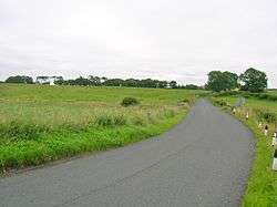
Bloak was a hamlet or clachan in East Ayrshire, Parish of Stewarton, Scotland. The habitation was situated between Auchentiber and Stewarton on the B778. It was originally built as a row of housing for crofters and farm workers. A small school remained open for some years after the hamlet ceased to exist.
History

The 1779 estate map of the Lainshaw Estate shows the hamlet of Bloak with the fields of South Crofts and North Crofts lying below Bowhouse Farm. Eight buildings are shown on either side of the road and located as far as the junction of the road to Kennox.[1] Bloak was once part of the 'Lands of Kirkwood' that formed a small estate in the Parish of Stewarton, East Ayrshire lying between Stewarton and Dunlop, which in 1678 became part of the lands of Lainshaw, known as the Lainshaw, Kirkwood and Bridgehouse Estate. Kirkwood was anciently known as Bloak Cunninghame.[2]
Bloak seems to have been a typical 'Farm Town', the origins of which lie in the common medieval sub-division of land called a 'ploughgate' (104 acres), this being the extent of land which one plough team of oxen could till in a year. This area was again subdivided into four plots known as 'husbandlands', each of 26 acres (110,000 m2). A husbandland could sustain and provide two oxen, and eight oxen were need for a plough-team. This arrangement led to small farm towns like Bloak being established with accommodation for at least four men and their families, living in six to eight houses. A similar hamlet or clachan still survives at Hessilhead, which also had a small school until around 1900.[3]
Cartographic evidence
Blaeu's edition of Timothy Pont's map of circa 1604 shows a Blook and Blook Mill.[4] In 1747 the settlement of Blook is indicated on Roy's map.[5] On Armstrong's map of 1775 shows a Bloate near Kirkwood.[6] Johnson's map of 1828 marks Bloak as a group of four buildings at Bowhouse Farm road end.[7] Thomson's map of 1832 shows Bloak.[8] A hamlet of around eight dwellings and a school are shown in 1858 with further dwellings at Bloakholmes. A path is shown running from the hamlet, shown as Bloak and Bloakcrofts, to the Linn Spout and Kirkwood Farm.[9] By 1895 the only remaining building is that of the school. Oddly the other buildings are not recorded as ruins and appear to have been demolished.[10] The school building is shown until 1958, but no longer marked as such, by which time a building had been constructed at the Bowhouse road end, surviving to this day (2012).
Views at Bloak
-

Section of old hedge boundary.
-

Site of the old school.
-

Site of an old lime kiln.
-

The Lugton Water at Bloak Bridge.
Bloak Well
Paterson[11] (1866) states that there is a mineral spring near Stewarton, called the Bloak Well.[12] gives the Scot's word 'blout' as meaning the 'eruption of fluid' or a place that is soft or wet. Both meanings would fit in this context. Blout and Bloak are very similar words, with Bloak Moss close by as well as the South and East Bloakhillhead farms.
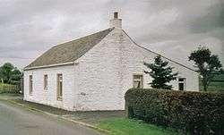

A well recorded as Bloak Well was first discovered in 1800,[13] around 1826 (Paterson 1866) or 1810[14] or 1800, by the fact that pigeons from Lainshaw House and the neighbouring parishes were found to flock here to drink. Mr. Cunningham of Lainshaw built a handsome house over the well in 1833 and appointed a keeper to take care of it as the mineral water was of some value owing to healing properties attributed to it. The well was located in the middle of the kitchen.[15] In 1846 the hamlet of Bloak is recorded as having a mineral well.[16]
Micro-history
A small elongated field known as Baiken Butts is shown at Bowhouse Farm,[1] suggesting a connection with archery as butts refers to ground used for practicising archery. The name of the farm may also be related to this.[17] A field going by the curious name of 'Kilwinning Butts' was located on the road leading to Dunlop Church in the 19th century.[18]
John Gillies Shields was born 12 Nov 1834 in Bloak, Stewarton, Ayrshire, and died 22 Sep 1908 in the nearby Galloway Ford farm. In 1845 he married Jane Guthrie, the daughter of Charles Guthrie. He married Elizabeth Howie in 1888.[19]
Margaret Young was the wife of John Gavan, a farmer who lived at Bloak. She died and was buried at Stewarton on 15 September 1827.[20]
William Nairn was the son of Robert Nairn and Agnes Millar. William was born 1785 in Bloak and married Janet Kerr on 8 November 1811 and secondly Elizabeth Jamieson.[21]
Knitted bonnets were made at Bloak.[22]
See also
References
- Notes
- 1 2 Crawford
- ↑ Lainshaw, Page 253
- ↑ Dickinson, Page 218.
- ↑ Blaeu's map Retrieved : 2012-07-17
- ↑ Roy's Map Retrieved : 2012-07-17
- ↑ Armstrong's map Retrieved : 2012-07-17
- ↑ Johnson
- ↑ Thomson's map Retrieved : 2012-07-17
- ↑ 1858 OS Map Retrieved : 2012-07-17
- ↑ 1895 OS Map
- ↑ Paterson.
- ↑ Robinson
- ↑ Smith
- ↑ Topographical Dictionary of Scotland (1846). Page 467
- ↑ Houston, Page 112.
- ↑ Ayrshire Roots retrieved : 2012-07-20
- ↑ Scots Dictionary Retrieved : 2012-07-18
- ↑ Lainshaw, Page 20
- ↑ Family Tree Maker Retrieved : 2012-07-20
- ↑ Ayrshire Roots Retrieved : 2012-07-20
- ↑ Family Tree Maker Retrieved : 2012-07-20
- ↑ Bainhouse Retrieved : 2012-07-20
- Sources
- Crawford, William (1779). Plan of the Estate of Lainshaw and Kirkwood.
- Dickinson, William Croft, Donaldson, G., and Milne, I. (1958). A Source Book of Scottish History. V.1. London : T. Nelson & Sons.
- Houston, John (1915). Auchentiber Moss, 14 August 1915. Annals of the Kilmarnock Glenfield Ramblers Society. 1913 - 1919.
- Johnson, William (1828). Map of Ayrshire from Estate Plans.
- Lainshaw, Register of Sasines.
- Paterson, James (1863–66). History of the Counties of Ayr and Wigton. V. - III - Cunninghame. J. Stillie. Edinburgh.
- Robinson, Mairi (2000). The Concise Scots Dictionary. Aberdeen. ISBN 1-902930-00-2.
- Smith, John (1895). Prehistoric Man in Ayrshire. Pub. Elliot Stock.
- Topographical Dictionary of Scotland (1846).
External links
| Wikimedia Commons has media related to Bloak. |