Bihunkot
| Bihunkot बिहुँकोट, बिहुँ | |
|---|---|
| Village Development Committee | |
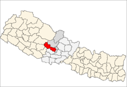
 Bihunkot Location in Nepal | |
| Coordinates: 28°16′N 83°29′E / 28.26°N 83.49°ECoordinates: 28°16′N 83°29′E / 28.26°N 83.49°E | |
| Country |
|
| Zone | Dhaulagiri Zone |
| District | Baglung District |
| Population (1991) | |
| • Total | 5,575 |
| • Religions | Hindu |
| Time zone | Nepal Time (UTC+5:45) |
Bihunkot is a Village Development Committee in Baglung District in the Dhaulagiri Zone of central Nepal. At the time of the 1991 Nepal census it had a population of 5,575 and had 1071 houses in the town.[1]
Location
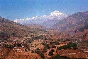
It is approximately 17 Kilometers from the Baglung Bazzar(city). The lifestyle here is rural. The majority peoples here are Brahmins, Kshetri, Magar, Dalit and other caste peoples. Means of transportation for the people here is on foot and due to the construction of Highway along the path, people are using buses and jeeps when it comes to long distance travel. But the roads are not back tarred so they may be blocked during the heavy rain in rainy season. Although, the situation is getting better as the construction is going on, it is not as expected. It is a cold place, located above 2000 meters from sea level and hence falls on Mountainous region. The Natural beauty stuns anyone visiting.
References
- ↑ "Nepal Census 2001". Nepal's Village Development Committees. Digital Himalaya. Archived from the original on October 12, 2008. Retrieved 2008-08-23.