Bessemer, Michigan
| Bessemer, Michigan | |
|---|---|
| City | |
|
Downtown Bessemer | |
 Location of Bessemer, Michigan | |
| Coordinates: 46°28′41″N 90°3′5″W / 46.47806°N 90.05139°W | |
| Country | United States |
| State | Michigan |
| County | Gogebic |
| Area[1] | |
| • Total | 5.47 sq mi (14.17 km2) |
| • Land | 5.47 sq mi (14.17 km2) |
| • Water | 0 sq mi (0 km2) |
| Elevation | 1,424 ft (434 m) |
| Population (2010)[2] | |
| • Total | 1,905 |
| • Estimate (2012[3]) | 1,854 |
| • Density | 348.3/sq mi (134.5/km2) |
| Time zone | Central (CST) (UTC-6) |
| • Summer (DST) | CDT (UTC-5) |
| ZIP code | 49911 |
| Area code(s) | 906 |
| FIPS code | 26-07960[4] |
| GNIS feature ID | 0621184[5] |
| Website | /cityofbessemer.org |
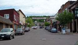
Bessemer is a city in the U.S. state of Michigan. As of the 2010 census, the city population was 1,914. It is the county seat of Gogebic County.[6]
The city is situated within Bessemer Township, but is politically independent. It is on US 2 with Ironwood several miles to the west and Wakefield several miles to the east. The Big Powderhorn, Blackjack and Indianhead ski areas are located within a few miles of Bessemer. Cross-country skiing and snowmobiling are also very popular in this area because of heavy snowfall influenced by nearby Lake Superior and this area is often referred to as "Big Snow Country".[7]
History
.jpg)
In 1880, a hunter and trapper Richard Langford, discovered iron ore under an overturned birch tree. However, Captain N. D. Moore is credited with disclosing the ore which led to the development of the Colby property. Mining began in 1883. By 1884, the Milwaukee Lake Shore and Western Railroad (later the Chicago and Northwestern) was being built from Antigo, WI to Ashland, WI by way of the new mines. The railroad company platted the town of Bessemer in 1884. On June 4, 1886 Gogebic County was separated from Ontonagon County. In March 1887, 360 voting members assembled and voted to organize the village of Bessemer. In the same year Gogebic County was officially created by the Michigan Legislature. Also in the year Bessemer and Ironwood called an election to see which city would be the county seat and also have the Gogebic County Courthouse. Ironwood men traveling to Bessemer to vote were made drunk and the train did not stop at the voting site. Ironwood lost and Bessemer gained the county seat. From 1884 to December 31, 1958, a period of seventy-five years, the iron ore shipment from all of Gogebic County totaled over 245 million tons. In 1966 the last mine in Bessemer-the Peterson Mine was closed. Many left the area to work in car factories in Kenosha, and the local economy underwent a serious decline.[8]
Bessemer is named for Sir Henry Bessemer (1813-1898), English inventor of steel manufacturing.[8]
Government
Bessemer is operated by an elected 5-member city council with day-to-day operations run by an appointed city manager. Staff also consists of administrative staff, public works department, and library staff. Bessemer also belongs to the Gogebic Range Water Authority.
Geography
According to the United States Census Bureau, the city has a total area of 5.47 square miles (14.17 km2), all land.[1] Majority of Bessemer is situated on the north side of Colby Hill and the city consists of many hills and valleys.
Demographics
| Historical population | |||
|---|---|---|---|
| Census | Pop. | %± | |
| 1890 | 2,566 | — | |
| 1900 | 3,911 | 52.4% | |
| 1910 | 4,583 | 17.2% | |
| 1920 | 5,482 | 19.6% | |
| 1930 | 4,035 | −26.4% | |
| 1940 | 4,080 | 1.1% | |
| 1950 | 3,509 | −14.0% | |
| 1960 | 3,304 | −5.8% | |
| 1970 | 2,805 | −15.1% | |
| 1980 | 2,553 | −9.0% | |
| 1990 | 2,272 | −11.0% | |
| 2000 | 2,148 | −5.5% | |
| 2010 | 1,905 | −11.3% | |
| Est. 2015 | 1,770 | [9] | −7.1% |
As of 2000 the median income for a household in the city was $27,639, and the median income for a family was $36,739. Males had a median income of $28,958 versus $21,708 for females. The per capita income for the city was $17,499. About 8.6% of families and 12.1% of the population were below the poverty line, including 17.0% of those under age 18 and 7.9% of those age 65 or over.
2010 census
As of the census[2] of 2010, there were 1,905 people, 888 households, and 511 families residing in the city. The population density was 348.3 inhabitants per square mile (134.5/km2). There were 1,140 housing units at an average density of 208.4 per square mile (80.5/km2). The racial makeup of the city was 96.4% White, 0.5% African American, 0.9% Native American, 0.3% Asian, 0.3% from other races, and 1.6% from two or more races. Hispanic or Latino of any race were 0.7% of the population.
There were 888 households of which 24.5% had children under the age of 18 living with them, 42.9% were married couples living together, 10.6% had a female householder with no husband present, 4.1% had a male householder with no wife present, and 42.5% were non-families. 38.3% of all households were made up of individuals and 19.4% had someone living alone who was 65 years of age or older. The average household size was 2.11 and the average family size was 2.76.
The median age in the city was 45.4 years. 20.3% of residents were under the age of 18; 9.1% were between the ages of 18 and 24; 20.1% were from 25 to 44; 29.5% were from 45 to 64; and 21% were 65 years of age or older. The gender makeup of the city was 49.1% male and 50.9% female.
News/Media
Newspapers
- Ironwood Daily Globe
- Wakefield News/Bessemer Pick & Axe
Area Radio Station Coverage
- WIMI 99.7 FM (Adult Contemporary/Variety)- Ironwood
- WJMS 590 AM (Talk/Country)- Ironwood
- WUPM 106.9 FM (Top 40/Variety)- Ironwood
- WHRY 1450 AM (Oldies)- Hurley
- WRJO 94.5 FM (Oldies)- Eagle River
- KQDS 95.3 FM (Grand Marais Translator) (Classic Rock)- Duluth
- WJJH 96.7 FM (Rock)- Ashland
- WBSZ 93.3 FM (Country)- Ashland
- WUPY 101.1 FM (Country)- Ontonagon
- WUWS 90.9 FM (Wisconsin Public Radio)- Ashland
Local Television Station Coverage
- WLUC TV 6 (Marquette)-NBC/FOX
- WNMU (Marquette)-PBS
- KDLH (Duluth)-CBS
- KBJR (Duluth)-NBC
- WDIO (Duluth)-ABC
- KQDS-TV (Duluth)-FOX
Notable people
- Otto Binder, science fiction and comic book author (Mary Marvel, Legion of Super-Heroes, and Supergirl); born in Bessemer
- Jay W. Johnson, U.S. congressmen for Wisconsin's 8th congressional district; born in Bessemer
- Arthur Redner, halfback for Fielding H. Yost's 1901 "Point-a-Minute" football team; lived in Bessemer
- Al Rossi, Olympic bronze medalist in rowing at the 1952 Summer Olympics; born in Bessemer[11]
- Richard A. Sofio, Michigan state representative and educator; born in Bessemer.[12]
- Kevin Borseth, women's basketball coach at The University of Wisconsin-Green Bay.
Transportation
- US Highway 2 is the Upper Peninsula's longest US Highway, stretching from St. Ignace to neighboring Ironwood.
- County Road 513 (Moore Street/Black River Road) begins in Bessemer at junction with US 2 and runs 15 miles (24 km) north to Black River Harbor on the shore of Lake Superior. A section of the road is designated the Black River National Forest Scenic Byway.
- County Road 200 (Old County Road) begins at the southwest end of Bessemer and travels west to Ironwood.
Indian Trails provides daily intercity bus service between St. Ignace and Ironwood,[13] while Gogebic County operates a small public bus system, the Gogebic County Transit Authority.
Commercial air service is available at the Gogebic-Iron County Airport (IWD) north of Ironwood. Air Choice One operates flights from Ironwood to Chicago and from Chicago to Ironwood daily. Flights to and from Minneapolis will be added beginning June 1, 2016.[14]
References
- 1 2 "US Gazetteer files 2010". United States Census Bureau. Archived from the original on 2012-07-14. Retrieved 2012-11-25.
- 1 2 "American FactFinder". United States Census Bureau. Retrieved 2012-11-25.
- ↑ "Population Estimates". United States Census Bureau. Archived from the original on 2013-06-17. Retrieved 2013-06-03.
- ↑ "American FactFinder". United States Census Bureau. Archived from the original on 2013-09-11. Retrieved 2008-01-31.
- ↑ "US Board on Geographic Names". United States Geological Survey. 2007-10-25. Retrieved 2008-01-31.
- ↑ "Find a County". National Association of Counties. Archived from the original on 2011-05-31. Retrieved 2011-06-07.
- ↑ "Western U.P. Skiing - Big Snow Country Downhill and Cross Country Skiing - Ironwood, Bessemer, Wakefield, Porcupine Mountains, Upper Peninsula Michigan". www.westernup.com. Retrieved 2016-04-08.
- 1 2 "History of Bessemer". www.cityofbessemer.org. Retrieved 2016-04-08.
- ↑ "Annual Estimates of the Resident Population for Incorporated Places: April 1, 2010 to July 1, 2015". Retrieved July 2, 2016.
- ↑ "Census of Population and Housing". Census.gov. Archived from the original on May 11, 2015. Retrieved June 4, 2015.
- ↑ "Al Rossi". Sports Reference. Retrieved March 2014. Check date values in:
|access-date=(help) - ↑ 'Richard A. Sofio-obituary,' Ironwood Daily Globe, March 4, 2009, pg. 8
- ↑ "St. Ignace–Sault Ste. Marie–Ironwood" (PDF). Indian Trails. January 15, 2013. Archived from the original (PDF) on 2014-07-04. Retrieved 2013-02-28.
- ↑ "Air Choice One to offer flights to Minneapolis". The Daily Globe. Retrieved 2016-04-08.
External links
| Wikisource has the text of a 1905 New International Encyclopedia article about Bessemer. |
- Bessemer Herald, Google news archive. —PDFs of 1,343 issues, dating from 1894 to 1970.
![]() Media related to Bessemer, Michigan at Wikimedia Commons
Media related to Bessemer, Michigan at Wikimedia Commons
Municipalities and communities of Gogebic County, Michigan, United States | ||
|---|---|---|
| Cities | 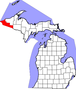 | |
| Charter township | ||
| General law townships | ||
| CDPs | ||
| Unincorporated communities | ||
| Indian reservation | ||
Coordinates: 46°28′53″N 90°03′11″W / 46.48139°N 90.05306°W