Benito Soliven, Isabela
| Benito Soliven | |
|---|---|
| Municipality | |
 Map of Isabela showing the location of Benito Soliven | |
.svg.png) Benito Soliven Location within the Philippines | |
| Coordinates: 16°59′N 121°57′E / 16.983°N 121.950°ECoordinates: 16°59′N 121°57′E / 16.983°N 121.950°E | |
| Country | Philippines |
| Region | Cagayan Valley (Region II) |
| Province | Isabela |
| District | 2nd District of Isabela |
| Barangays | 29 |
| Government[1] | |
| • Mayor | Benjamin E. Sanglay |
| Area[2] | |
| • Total | 184.40 km2 (71.20 sq mi) |
| Population (2010)[3] | |
| • Total | 27,337 |
| • Density | 150/km2 (380/sq mi) |
| Time zone | PST (UTC+8) |
| ZIP code | 3331 |
| Dialing code | 78 |
| Income class | 4th class; rural |
Benito Soliven is a fourth class municipality in the province of Isabela, Philippines. According to the 2010 census, it had a population of 27,337 people.[3]
The town is named after the Benito Soliven, Congressman of Santo Domingo, Ilocos Sur, during the Commonwealth government.
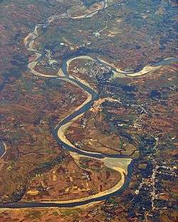
Aerial view of Benito Soliven, with San Mariano in the background
Barangays
Benito Soliven is politically subdivided into 29 barangays.[2]
- Andabuen
- Ara
- Binogtungan
- Capuseran (Capurocan)
- Dagupan
- Danipa
- District II (Pob.)
- Gomez
- Guilingan
- La Salette
- Makindol
- Maluno Norte
- Maluno Sur
- Nacalma
- New Magsaysay
- District I (Pob.)
- Punit
- San Carlos
- San Francisco
- Santa Cruz
- Sevillana
- Sinipit
- Lucban
- Villaluz
- Yeban Norte
- Yeban Sur
- Santiago
- Placer
- Balliao
Demographics
| Population census of Benito Soliven | ||
|---|---|---|
| Year | Pop. | ±% p.a. |
| 1990 | 20,236 | — |
| 1995 | 20,685 | +0.41% |
| 2000 | 22,192 | +1.52% |
| 2007 | 25,151 | +1.74% |
| 2010 | 27,337 | +3.08% |
| 2015 | 29,624 | +1.54% |
| Source: National Statistics Office[3] | ||
Climate
| Climate data for Benito Soliven, Isabela | |||||||||||||
|---|---|---|---|---|---|---|---|---|---|---|---|---|---|
| Month | Jan | Feb | Mar | Apr | May | Jun | Jul | Aug | Sep | Oct | Nov | Dec | Year |
| Average high °C (°F) | 29 (84) |
30 (86) |
32 (90) |
35 (95) |
35 (95) |
35 (95) |
34 (93) |
33 (91) |
32 (90) |
31 (88) |
30 (86) |
28 (82) |
32 (89.6) |
| Average low °C (°F) | 19 (66) |
20 (68) |
21 (70) |
23 (73) |
23 (73) |
24 (75) |
23 (73) |
23 (73) |
23 (73) |
22 (72) |
21 (70) |
20 (68) |
21.8 (71.2) |
| Average precipitation mm (inches) | 31.2 (1.228) |
23 (0.91) |
27.7 (1.091) |
28.1 (1.106) |
113.5 (4.469) |
141.4 (5.567) |
176.4 (6.945) |
236.6 (9.315) |
224.9 (8.854) |
247.7 (9.752) |
222.9 (8.776) |
178 (7.01) |
1,651.4 (65.023) |
| Average rainy days | 10 | 6 | 5 | 5 | 13 | 12 | 15 | 15 | 15 | 17 | 16 | 15 | 144 |
| Source: World Weather Online[4] | |||||||||||||
References
- ↑ "Official City/Municipal 2013 Election Results". Intramuros, Manila, Philippines: Commission on Elections (COMELEC). 11 September 2013. Retrieved 10 January 2014.
- 1 2 "Province: ISABELA". PSGC Interactive. Makati City, Philippines: National Statistical Coordination Board. Archived from the original on 1 January 1970. Retrieved 10 January 2014.
- 1 2 3 "Total Population by Province, City, Municipality and Barangay: as of May 1, 2010" (PDF). 2010 Census of Population and Housing. National Statistics Office. Archived from the original (PDF) on 14 November 2013. Retrieved 10 January 2014.
- ↑ "Benito Soliven, Isabela: Average Temperatures and Rainfall". World Weather Online. Retrieved 31 October 2015.
External links
- Philippine Standard Geographic Code
- Philippine Census Information
- Municipality of Benito Soliven
- Local Governance Performance Management System
 |
Ilagan | | ||
| Naguilian | |
San Mariano | ||
| ||||
| | ||||
| Cauayan |
Ilagan (capital) | |
| Municipalities |
|
| Component Cities | |
| Independent Component City |
|
| Barangays | |
This article is issued from Wikipedia - version of the 10/30/2016. The text is available under the Creative Commons Attribution/Share Alike but additional terms may apply for the media files.