Benickebrinken
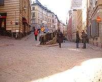
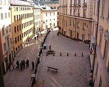
Södra/Norra Benickebrinken are two sloping streets in Gamla stan, the old town in central Stockholm, Sweden, stretching from Österlånggatan up to Svartmangatan.
The Salvation Army opened a pantry on Number 2 in 1891 and a night refuge for homeless men the following year, both institutions remained in operation until the 1970s. Today the building is used as a board-and-lodging accommodation for alcoholics.[1]
Public toilets were installed under the slope in 2005-2006.[2]
Etymology
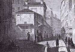
The present name is derived from a Jören Benick, a man who had a tavern here named Solen ("The Sun") after the sign hanging in the street. The tavern was located in a block demolished in the end of the 19th century and located on the eastern side of the then extremely narrow slopes. It was later taken over by Jören's grandsons, both mentioned as the city's official innkeepers in the beginning of the 17th century.[3]
The slopes were originally named Svartbrödrabrinken and Svartmunkabrinken ("Black Brother's/Monk's Slope") after the Black Friars' Monastery located on the western side of the southern slope until the Reformation (1520-1530). The monastery was built on land given to the Dominicans following the coronation of King Magnus Eriksson (1316–1377) in 1336. A cellar from the monastery, at the time serving as a lodging and still containing the original stoves, is found under the present building on number 4.[3][4] A pattern of sets in the street Prästgatan still shows the extent of the monastery walls, and human bones discovered during an archaeological excavation in 1993 showed the graveyard of the monastery extended well into the northern part of the present southern slope.[5]
History
Before King Sigismund's (1566-1632) arrival to Stockholm in 1593, a large number of accommodations and taverns were urged to be put in order all over the city, and, to guide foreign guests, the taverns were requested to put signs in the streets displaying symbols "like is the manner abroad". By the early 17th century, however, the number of taverns and lodging houses didn't by far match the demand, so the mayor reintroduced an ordinance stipulating two inns in every block; the tavern of Benicke together with five other taverns is shortly thereafter given a charter, requesting the premises to be used exclusively for the purpose — "all wine, beer, and other foreign beverages be sold and tapped" (all wijn, ööll och andra fremmande drycker selias och upptappas).[6]
In various contemporary sources, the house of Benicke not only gradually gave its name to the slopes, but was also used as a point of references: In 1564, a house is said to be located "by Blackfriars slope right across Jörenn Beneke's house" (wiid Swartmunka brincken twerth vtöffver Jörenn Benekes huss). In 1605, a house offered for sale is said to be located "in Jörenn Benichson's slope, on the north side of Jörenn Benichsons house" (i Jören Benichsons brinck, på nörre sidhenn om Jörenn Benichsons hus), and his name appears again in 1622 when another building is put up for sale. Finally, on a map dated 1733 the slopes are labelled with their present names (Nor och Söder Benike Brincken).[3]
See also
References
- ↑ Béatrice Glase, Gösta Glase (1988). "Östra Stadsholmen". Gamla stan med Slottet och Riddarholmen (in Swedish) (3rd ed.). Stockholm: Bokförlaget Trevi. pp. 52–53. ISBN 91-7160-823-0.
- ↑ "Toalett vid Benickebrinken". City of Stockholm. 2006-03-12?. Retrieved 2007-02-25. Check date values in:
|date=(help) - 1 2 3 "Innerstaden: Gamla stan". Stockholms gatunamn (in Swedish) (2nd ed.). Stockholm: Kommittén för Stockholmsforskning. 1992. p. 63. ISBN 91-7031-042-4.
- ↑ Martin Stugart (2007?-01-12). "Varifrån har Norra och Södra Benickebrinken i Gamla stan fått sina namn.". Dagens Nyheter. Archived from the original on 2007-10-01. Retrieved 2007-02-25. Check date values in:
|date=(help) - ↑ Barbro Århem (1993). "Prästgatan, Österlånggatan, Södra Benickebrinken" (PDF). Stockholm City Museum. Retrieved 2007-02-25.
- ↑ Fredrik Ulrik Wrangel (1912). "Stockholmiana I-IV: Värdshus och vinkällare vid 1600-talets början". Project Runeberg. pp. 7 ff. Retrieved 2007-02-25.
- Note
- While the two streets on the hillock are officially regarded as two separate streets, for the purpose of this article they are treated together because of their limited extent and shared history.
External links
- hitta.se - Location map and virtual walk:
- Stockholmskällan - Historical photos
Coordinates: 59°19′24.4″N 18°04′24.7″E / 59.323444°N 18.073528°E