Bellville, Georgia
| Bellville, Georgia | |
|---|---|
| City | |
 | |
| Motto: Fides Veritas Heriditas | |
 Location in Evans County and the state of Georgia | |
| Coordinates: 32°9′10″N 81°58′24″W / 32.15278°N 81.97333°WCoordinates: 32°9′10″N 81°58′24″W / 32.15278°N 81.97333°W | |
| Country | United States |
| State | Georgia |
| County | Evans |
| Area | |
| • Total | 1.01 sq mi (2.62 km2) |
| • Land | 0.98 sq mi (2.55 km2) |
| • Water | 0.03 sq mi (0.07 km2) |
| Elevation | 184 ft (56 m) |
| Population (2010) | |
| • Total | 123 |
| • Density | 125/sq mi (48.2/km2) |
| Time zone | Eastern (EST) (UTC-5) |
| • Summer (DST) | EDT (UTC-4) |
| ZIP code | 30414 |
| Area code(s) | 912 |
| FIPS code | 13-06688[1] |
| GNIS feature ID | 0354538[2] |
Bellville is a city in Evans County, Georgia, United States. As of the 2010 census, the city had a population of 123.[3] It is home to Pinewood Christian Academy and is the hometown of writer/director James Kicklighter.
Geography
Bellville is located in western Evans County at 32°9′10″N 81°58′24″W / 32.15278°N 81.97333°W (32.152828, -81.973366),[4] along U.S. Route 280, which leads east 4 miles (6 km) to Claxton, the county seat, and southwest 10 miles (16 km) to Reidsville. Georgia State Route 292 branches off US 280 and passes through the center of Bellville, leading west 8 miles (13 km) to Collins. Georgia State Route 169 crosses GA 292 in the center of Bellville, running north-south.
According to the United States Census Bureau, the city has a total area of 1.01 square miles (2.62 km2), of which 0.98 square miles (2.55 km2) is land and 0.03 square miles (0.07 km2), or 2.53%, is water.[5]
Climate
Bellville has a humid subtropical climate according to the Köppen classification. The city has hot and humid summers with average highs of 94 degrees and lows of 70 degrees in July. Winters are mild with average January highs of 61 degrees and lows of 36 degrees. Winter storms are rare, but they can happen on occasion.[6]
| Climate data for Bellville, Georgia | |||||||||||||
|---|---|---|---|---|---|---|---|---|---|---|---|---|---|
| Month | Jan | Feb | Mar | Apr | May | Jun | Jul | Aug | Sep | Oct | Nov | Dec | Year |
| Record high °F (°C) | 81 (27) |
86 (30) |
89 (32) |
96 (36) |
98 (37) |
106 (41) |
107 (42) |
105 (41) |
104 (40) |
96 (36) |
87 (31) |
84 (29) |
107 (42) |
| Average high °F (°C) | 61 (16) |
66 (19) |
73 (23) |
78 (26) |
86 (30) |
91 (33) |
94 (34) |
92 (33) |
87 (31) |
80 (27) |
71 (22) |
63 (17) |
78.5 (25.9) |
| Average low °F (°C) | 36 (2) |
39 (4) |
44 (7) |
50 (10) |
59 (15) |
67 (19) |
71 (22) |
70 (21) |
65 (18) |
54 (12) |
45 (7) |
38 (3) |
53.2 (11.7) |
| Record low °F (°C) | −2 (−19) |
13 (−11) |
16 (−9) |
28 (−2) |
41 (5) |
48 (9) |
58 (14) |
56 (13) |
45 (7) |
30 (−1) |
22 (−6) |
13 (−11) |
−2 (−19) |
| Average precipitation inches (mm) | 4.36 (110.7) |
3.57 (90.7) |
3.25 (82.6) |
2.95 (74.9) |
3.21 (81.5) |
5.12 (130) |
4.68 (118.9) |
5.41 (137.4) |
3.73 (94.7) |
3.87 (98.3) |
2.49 (63.2) |
3.17 (80.5) |
45.81 (1,163.4) |
| Source: The Weather Channel[7] | |||||||||||||
Demographics
| Historical population | |||
|---|---|---|---|
| Census | Pop. | %± | |
| 1970 | 234 | — | |
| 1980 | 173 | −26.1% | |
| 1990 | 192 | 11.0% | |
| 2000 | 130 | −32.3% | |
| 2010 | 123 | −5.4% | |
| Est. 2015 | 122 | [8] | −0.8% |
As of the census[1] of 2010, there were 123 people, 54 households, and 42 families residing in the city. The population density was 132.5 people per square mile (51.2/km²). There were 64 housing units at an average density of 65.2 per square mile (25.2/km²). The racial makeup of the city was 93.08% White, 5.38% African American and 1.54% Asian. Hispanic or Latino of any race were 6.92% of the population.
There were 54 households out of which 20.4% had children under the age of 18 living with them, 63.0% were married couples living together, 9.3% had a female householder with no husband present, and 22.2% were non-families. 22.2% of all households were made up of individuals and 13.0% had someone living alone who was 65 years of age or older. The average household size was 2.41 and the average family size was 2.79.
In the city the population was spread out with 20.8% under the age of 18, 5.4% from 18 to 24, 20.8% from 25 to 44, 30.8% from 45 to 64, and 22.3% who were 65 years of age or older. The median age was 47 years. For every 100 females there were 100.0 males. For every 100 females age 18 and over, there were 110.2 males.
The median income for a household in the city was $57,708, and the median income for a family was $60,000. Males had a median income of $32,083 versus $28,750 for females. The per capita income for the city was $19,414. There were no families and 5.4% of the population living below the poverty line, including no under eighteens and 35.3% of those over 64.
References
- 1 2 "American FactFinder". United States Census Bureau. Archived from the original on 2013-09-11. Retrieved 2008-01-31.
- ↑ "US Board on Geographic Names". United States Geological Survey. 2007-10-25. Retrieved 2008-01-31.
- ↑ "Fact Finder 2". Retrieved 29 Nov 2013.
- ↑ "US Gazetteer files: 2010, 2000, and 1990". United States Census Bureau. 2011-02-12. Retrieved 2011-04-23.
- ↑ "Geographic Identifiers: 2010 Demographic Profile Data (G001): Bellville city, Georgia". American Factfinder. U.S. Census Bureau. Retrieved January 27, 2016.
- ↑ "Average Weather for Bellville, Georgia". Retrieved 2013-11-29.
- ↑ "Average Weather for Bellvile, GA – Temperature and Precipitation". Retrieved November 29, 2013.
- ↑ "Annual Estimates of the Resident Population for Incorporated Places: April 1, 2010 to July 1, 2015". Retrieved July 2, 2016.
- ↑ "Census of Population and Housing". Census.gov. Archived from the original on May 11, 2015. Retrieved June 4, 2015.
External links
- Bellville historical marker
Municipalities and communities of Evans County, Georgia, United States | ||
|---|---|---|
| Cities | 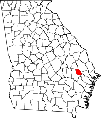 | |