Bassersdorf
| Bassersdorf | ||
|---|---|---|
 | ||
| ||
 Bassersdorf | ||
|
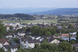
Location of Bassersdorf  | ||
| Coordinates: 47°27′N 8°38′E / 47.450°N 8.633°ECoordinates: 47°27′N 8°38′E / 47.450°N 8.633°E | ||
| Country | Switzerland | |
| Canton | Zürich | |
| District | Bülach | |
| Area[1] | ||
| • Total | 9.02 km2 (3.48 sq mi) | |
| Elevation | 460 m (1,510 ft) | |
| Population (Dec 2015[2]) | ||
| • Total | 11,561 | |
| • Density | 1,300/km2 (3,300/sq mi) | |
| Postal code | 8303 | |
| SFOS number | 0052 | |
| Surrounded by | Dietlikon, Kloten, Lindau, Nürensdorf, Wangen-Brüttisellen | |
| Twin towns | Aigle (Switzerland) | |
| Website |
www SFSO statistics | |

Bassersdorf is a municipality in the Swiss canton of Zürich, located in the district of Bülach, and belongs to the Glatt Valley (German: Glattal).
History
The name, mentioned in 1155 as Bazzelstorf and maybe yet in the early 11th century as Basselstorff,[3] is a compound consisting of dorf, a widespread constituent in alemannic placenames meaning ‚hamlet, farm, village, estate‘, and the genitive form of an anthroponym, probably OHG *Bazzilo (or its feminine Bacila, documented in the Abbey of St. Gall).[4] The Alemannic settlement dates to the 8th or 9th century. Due to its position halfway between the towns of Zürich and Winterthur, the village gained some importance as a relay during the 18th and 19th centuries.
Under the Helvetic Republic (1798–1803), it was the district capital.
In 2001, Crossair Flight 3597 crashed into the ground at Bassersdorf while on approach to land at Zürich Airport. Twenty-four of the thirty-three people on board were killed.[5] The investigation concluded that the accident was a controlled flight into terrain (CFIT) caused by a series of pilot errors and navigation mistakes that led the plane off-course. This course deviation caused the plane to crash into a hilltop, 4.05 km (2.52 mi) short of and 150 m (490 ft) north of its assigned landing strip, runway 28.[6]
Geography
Bassersdorf has an area of 9 square kilometers (3.5 sq mi). Of this area, 42.5% is used for agricultural purposes, while 30.8% is forested. Of the rest of the land, 26.3% is settled (buildings or roads) and the remainder (0.3%) is non-productive (rivers, glaciers or mountains).[7]
The municipality is located on the edge of the mid-Glatt Valley. Since 1931, the village of Baltenswil has been part of the municipality.
Demographics
Bassersdorf has a population (as of 31 December 2015) of 11,561.[2] As of 2007, 21.2% of the population was made up of foreign nationals. Over the last 10 years the population has grown at a rate of 50.5%. Most of the population (as of 2000) speaks German (85.8%), with Italian being second most common ( 3.8%) and Serbo-Croatian being third ( 1.7%).
In the 2007 election the most popular party was the SVP which received 37.2% of the vote. The next three most popular parties were the SPS (19.6%), the FDP (12.4%) and the CSP (10.3%).
The age distribution of the population (as of 2000) is children and teenagers (0–19 years old) make up 23.4% of the population, while adults (20–64 years old) make up 65.2% and seniors (over 64 years old) make up 11.4%. In Bassersdorf about 75.5% of the population (between age 25-64) have completed either non-mandatory upper secondary education or additional higher education (either university or a Fachhochschule).[7] The historical population is given in the following table:[3]
| year | population |
|---|---|
| 1420 | 39 Households |
| 1634 | 310 |
| 1710 | 718 |
| 1836 | 825 |
| 1850 | 959 |
| 1900 | 1,092 |
| 1950 | 2,143 |
| 1970 | 5,590 |
| 2000 | 7,515 |
Economy
Compaq at one point operated its Switzerland offices in Bassersdorf.[8]
Bassersdorf has an unemployment rate of 3.46%. As of 2005, there were 53 people employed in the primary economic sector and about 17 businesses involved in this sector. 617 people are employed in the secondary sector and there are 67 businesses in this sector. 2380 people are employed in the tertiary sector, with 267 businesses in this sector.[7]
Transportation
Bassersdorf railway station is a stop of the S-Bahn Zürich on the lines S24 and S7.
Twin towns – Sister cities
Bassersdorf is twinned with:
 Aigle, Switzerland
Gallery
-
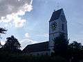
St. Johannis Church
-

Former train-station (relocated in 1980)
-

Sawmill in the Wisental
Sources
- ↑ Arealstatistik Standard - Gemeindedaten nach 4 Hauptbereichen
- 1 2 Canton of Zurich Statistical Office (German) accessed 27 April 2016
- 1 2 Bassersdorf in German, French and Italian in the online Historical Dictionary of Switzerland.
- ↑ Andres Kristol, Bassersdorf ZH (Bülach) in: Dictionnaire toponymique des communes suisses – Lexikon der schweizerischen Gemeindenamen – Dizionario toponomastico dei comuni svizzeri (DTS|LSG), Centre de dialectologie, Université de Neuchâtel, Verlag Huber, Frauenfeld/Stuttgart/Wien 2005, ISBN 3-7193-1308-5 and Éditions Payot, Lausanne 2005, ISBN 2-601-03336-3, p. 126.
- ↑ Final Report No. 1793 by the Aircraft Accident Investigation Bureau concerning the accident to the aircraft AVRO 146-RJ100, HB-IXM, operated by Crossair under flight number CRX 3597, on 24 November 2001 near Bassersdorf/ZH Archived 2012-02-16 at WebCite pg. 12
- ↑ Final Report No. 1793 by the Aircraft Accident Investigation Bureau concerning the accident to the aircraft AVRO 146-RJ100, HB-IXM, operated by Crossair under flight number CRX 3597, on 24 November 2001 near Bassersdorf/ZH Archived 2012-02-16 at WebCite pg. 11
- 1 2 3 Swiss Federal Statistical Office Archived January 5, 2016, at the Wayback Machine. accessed 29-Jul-2009
- ↑ Compaq Offices Worldwide at the Wayback Machine (archived December 25, 1996)
External links
| Wikimedia Commons has media related to Bassersdorf. |
- Official website (German)
- Bassersdorf in German, French and Italian in the online Historical Dictionary of Switzerland.
- Statistics (German)