Barysiai Airport
| Barysiai Airport Barysių aerodromas | |||||||||||
|---|---|---|---|---|---|---|---|---|---|---|---|
 | |||||||||||
| IATA: none – ICAO: EYSB | |||||||||||
| Summary | |||||||||||
| Airport type | Public | ||||||||||
| Serves | Šiauliai, Lithuania | ||||||||||
| Location | Barysiai, Lithuania | ||||||||||
| Elevation AMSL | 270 ft / 82 m | ||||||||||
| Coordinates | 56°04′14″N 023°33′29″E / 56.07056°N 23.55806°ECoordinates: 56°04′14″N 023°33′29″E / 56.07056°N 23.55806°E | ||||||||||
| Map | |||||||||||
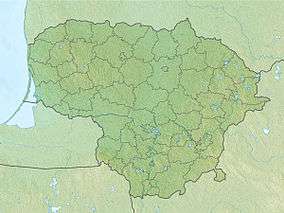 EYSB Location of airport in Lithuania | |||||||||||
| Runways | |||||||||||
| |||||||||||
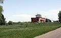
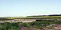
Barysiai Airport (Lithuanian: Barysių aerodromas) (ICAO: EYSB[3]) is an airport in Barysiai,[1] a village in the Joniškis district municipality of Šiauliai County in northern Lithuania. From 1959 to 1992 it was a civil airport serving the city of Šiauliai.
Facilities
The airport resides at an elevation of 270 feet (82 m) above mean sea level. It has one runway designated 10/28 with an asphalt surface measuring 1,000 by 30 metres (3,281 ft × 98 ft).[1]
See also
- Šiauliai International Airport (IATA: SQQ, ICAO: EYSA)
References
- 1 2 3 Airport information for EYSB from DAFIF (effective October 2006)
- ↑ Airport information for HLJ at Great Circle Mapper. Source: DAFIF (effective October 2006).
- ↑ Accident history for EYSB at Aviation Safety Network
This article is issued from Wikipedia - version of the 5/8/2013. The text is available under the Creative Commons Attribution/Share Alike but additional terms may apply for the media files.