Barnsdall Main Street Well Site
|
Barnsdall Main Street Well Site | |
|
Oil Well in middle of Main Street, Barnsdall, Oklahoma. April 11, 2007 | |
| Location | Barnsdall, Oklahoma |
|---|---|
| Coordinates | 36°33′41.93″N 96°9′56.57″W / 36.5616472°N 96.1657139°WCoordinates: 36°33′41.93″N 96°9′56.57″W / 36.5616472°N 96.1657139°W |
| Built | 1914 |
| Architectural style | Other |
| MPS | Energy-Related Properties in Northeastern Oklahoma MPS |
| NRHP Reference # | 97001153 [1] |
| Added to NRHP | October 1, 1997 |
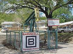
The Barnsdall Main Street Well (also known as Indian Territory Illuminating Oil Company Well #20 Osage County) is a formerly active oil well in the middle of Main Street in the town of Barnsdall, Oklahoma. It is believed to be the only such oil well anywhere in the world. It was listed on the National Register of Historic Places (NRHP) on October 1, 1997, as part of the "Energy Related Resources in Northeastern Oklahoma Multiple Property Submission".[2] According to signage at the site, the well was completed on March 18, 1914, with a depth of 1771 feet. It remained active until the 1960s.[3]
Description
The Barnsdall Main Street Well actually sits on Main Street,28 feet (8.5 m) west of 9th Street in northwest Barnsdall.[lower-alpha 1] According to the NRHP application, "...this is the only publicly accessible historic well site in the Barnsdall oil field." It was listed under NRHP Criterion A, with a period of significance of 1914-1930.[4] The application also states that at maximum production, this well could have produced 8 to 10 barrels of oil per day.[lower-alpha 2]
The pumping unit that is now on site is not the original "flathead" model, which was replaced sometime after 1962. The more modern unit is skid mounted whose prime mover (an electric motor), gears, wellhead connections and rods appear in good condition, though the unit no longer operates. The unit is surrounded by a 4 feet (1.2 m) high chain-link fence, blocking access to the pump area.[4]
The NRHP application states that the fact that the pump and fence are not original (and therefore not contributing resources) do not compromise the site's integrity. The explanation is that the original casing head is still in place and that it marks the exact location of the well. Moreover, the location and setting have not changed appreciably since the period of significance.[4]
Notes
- ↑ 9th Street is better known as State Highway 11
- ↑ Barrels per day (BPD) is a standard unit of measurement in the oil industry. One Barrel = 42 U. S. gallons.
References
- ↑ National Park Service (2007-01-23). "National Register Information System". National Register of Historic Places. National Park Service.
- ↑ "Weekly List of Actions Taken on Properties: 11/03/97 through 11/07/97". National Register of Historic Places. Retrieved 10 September 2016.
- ↑ Savage, Cynthia (January 1998). "Four Oklahoma Properties listed in National Register" (PDF). Preservation Oklahoma News. Preservation Oklahoma, Inc. and the Oklahoma Historical Society. Retrieved 10 September 2016.
- 1 2 3 "Barnsdall Main Street Well Site - National Register of Historic Places Registration Form." August 1, 1997. Accessed November 29, 2016.