Barnsdall, Oklahoma
| Barnsdall, Oklahoma | |
|---|---|
| City | |
| Nickname(s): Bigheart | |
 Location of Barnsdall, Oklahoma | |
| Coordinates: 36°33′34″N 96°9′40″W / 36.55944°N 96.16111°WCoordinates: 36°33′34″N 96°9′40″W / 36.55944°N 96.16111°W | |
| Country | United States |
| State | Oklahoma |
| County | Osage |
| Area | |
| • Total | 0.6 sq mi (1.6 km2) |
| • Land | 0.6 sq mi (1.6 km2) |
| • Water | 0.0 sq mi (0.0 km2) |
| Elevation | 741 ft (226 m) |
| Population (2010) | |
| • Total | 1,243 |
| • Density | 2,195.3/sq mi (847.6/km2) |
| Time zone | Central (CST) (UTC-6) |
| • Summer (DST) | CDT (UTC-5) |
| ZIP code | 74002 |
| Area code(s) | 539/918 |
| FIPS code | 40-04250[1] |
| GNIS feature ID | 1089868[2] |
Barnsdall is a city in Osage County, Oklahoma, United States. The population was 1,243 at the 2010 census, a decline of 6.2 percent from 1,325 at the 2000 census.[3]
History
The town was founded in 1905 and originally named Bigheart, for the Osage Chief James Bigheart. It was initially a 160-acre site along the Midland Valley Railroad in March, 1905. The railroad opened Bigheart Station in September, 1905 and the Bigheart Post Office opened in January, 1906. The town was exempted from the Osage allotment, so lots could be sold to anyone. Lots were auctioned in May, 1906. The first newspaper, the Bigheart Star, first appeared in 1906.[4]
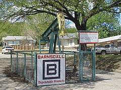
Joshua Cosden built the Southwest Refining Company oil refinery in 1910. He sold it to an undisclosed buyer in 1917, Theodore Newton Barnsdall, owner of the Barnsdall Oil Company, bought the refinery in 1921. Barnsdall had discovered the nearby Bigheart (later Barnsdall) oilfield in 1916. The town was renamed on January 1, 1922 in honor of Mr. Barnsdall.[4]
The town of Barnsdall experienced a tornado in April 1911, a major fire in March 1913 and a flood in September 1915. Despite these calamities, the population increased from 307 in 1910 to 2,099 in 1920.[4] That proved to be the high point of population in the town.
Barnsdall Refining Company renamed itself Bareco Oil Company in 1940. It ceased refining oil in 1946 and began producing microcrystalline waxes that year. Petrolite Corporation (now part of Baker Hughes Inc.) bought Bareco and has continued to operate the plant.[4] E. L. Doherty bought the holdings of Theodore N. Barnsdall, founder of Barnsdall Oil Company, in 1912.[5]
Geography
Barnsdall is located at 36°33′34″N 96°09′40″W / 36.559344°N 96.161062°W.[6] It is 17 miles (27 km) southeast of Pawhuska, the Osage County seat, and 40 miles (64 km) northwest of Tulsa.[4]
According to the United States Census Bureau, the city has a total area of 0.6 square miles (1.6 km2), all of it land.
Climate
| Climate data for Barnsdall, Oklahoma | |||||||||||||
|---|---|---|---|---|---|---|---|---|---|---|---|---|---|
| Month | Jan | Feb | Mar | Apr | May | Jun | Jul | Aug | Sep | Oct | Nov | Dec | Year |
| Average high °F (°C) | 46.7 (8.2) |
52.5 (11.4) |
63.1 (17.3) |
74.1 (23.4) |
80.5 (26.9) |
88.3 (31.3) |
94.5 (34.7) |
93.8 (34.3) |
85.2 (29.6) |
75.0 (23.9) |
61.2 (16.2) |
49.7 (9.8) |
72.1 (22.3) |
| Average low °F (°C) | 22.5 (−5.3) |
27.4 (−2.6) |
37.0 (2.8) |
48.1 (8.9) |
56.5 (13.6) |
65.2 (18.4) |
69.8 (21) |
67.6 (19.8) |
60.3 (15.7) |
48.0 (8.9) |
37.0 (2.8) |
26.4 (−3.1) |
47.2 (8.4) |
| Average precipitation inches (mm) | 1.4 (36) |
1.9 (48) |
3.7 (94) |
3.3 (84) |
4.8 (122) |
4.7 (119) |
2.9 (74) |
3.5 (89) |
5.6 (142) |
3.2 (81) |
3.0 (76) |
1.9 (48) |
39.9 (1,013) |
| Source: Weatherbase.com [7] | |||||||||||||
Events
Barnsdall's annual Bigheart Day is held The Saturday before Memorial Day. It centered on a parade and other events, such as:
- Fishing Tournament at Lake Waxhoma. Ages 4–12.
- Frog Race and Turtle Race after the fishing tournament.
- Carnival; depends on the city budget.
- Tricycle races.
- Live music. Bands that have played, Celestial Impulse(disbanded),Accusing of the Believing(disbanded),and Pake Mackentire
- Street vendors.
- Parade at noon.
- Alumni panther football game.
- Street dance; usually 7pm - Midnight.
- Alumni Basketball game.
Barnsdall also hosts an annual Christmas Parade.
Demographics
| Historical population | |||
|---|---|---|---|
| Census | Pop. | %± | |
| 1910 | 307 | — | |
| 1920 | 2,099 | 583.7% | |
| 1930 | 2,001 | −4.7% | |
| 1940 | 1,831 | −8.5% | |
| 1950 | 1,708 | −6.7% | |
| 1960 | 1,663 | −2.6% | |
| 1970 | 1,579 | −5.1% | |
| 1980 | 1,501 | −4.9% | |
| 1990 | 1,316 | −12.3% | |
| 2000 | 1,325 | 0.7% | |
| 2010 | 1,243 | −6.2% | |
| Est. 2015 | 1,209 | [8] | −2.7% |
As of the census[1] of 2000, there were 1,325 people, 542 households, and 357 families residing in the city. The population density was 2,195.3 people per square mile (852.6/km2). There were 630 housing units at an average density of 1,043.8 per square mile (405.4/km2). The racial makeup of the city was 74.26% White, 15.62% Native American, 0.30% Asian, 0.23% from other races, and 9.58% from two or more races. Hispanic or Latino of any race were 1.81% of the population.
There were 542 households out of which 28.4% had children under the age of 18 living with them, 53.7% were married couples living together, 9.0% had a female householder with no husband present, and 34.1% were non-families. 31.7% of all households were made up of individuals and 16.6% had someone living alone who was 65 years of age or older. The average household size was 2.38 and the average family size was 3.00.
In the city the population was spread out with 24.5% under the age of 18, 8.4% from 18 to 24, 24.6% from 25 to 44, 22.8% from 45 to 64, and 19.8% who were 65 years of age or older. The median age was 40 years. For every 100 females there were 85.6 males. For every 100 females age 18 and over, there were 80.4 males.
The median income for a household in the city was $25,598, and the median income for a family was $34,934. Males had a median income of $31,731 versus $18,472 for females. The per capita income for the city was $13,435. About 8.0% of families and 11.0% of the population were below the poverty line, including 9.1% of those under age 18 and 15.9% of those age 65 or over.
Notable people
- Singer Anita Bryant (born, 1940), Miss America runner-up in 1958, was born in Barnsdall.
- Movie Star Clark Gable, famous for his role in "Gone With the Wind", came to Barnsdall with his father for a short while when the town was in the oil business. The native stone shotgun house where he resided on West Walnut Street still stands. Clark was also noted to sing in a quartet while he lived in Bigheart (Barnsdall).
Attractions
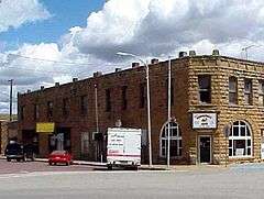
Barnsdall has two properties listed on the National Register of Historic Places:
- The Bank of Bigheart,
- The Barnsdall Main Street Well Site, an oil well in the middle of Main Street.
References
- 1 2 "American FactFinder". United States Census Bureau. Archived from the original on 2013-09-11. Retrieved 2008-01-31.
- ↑ "US Board on Geographic Names". United States Geological Survey. 2007-10-25. Retrieved 2008-01-31.
- ↑ MuniNet Guide: Barnsdall, Oklahoma Archived October 14, 2013, at the Wayback Machine.
- 1 2 3 4 5 Jon D. May, "Barnsdall," Encyclopedia of Oklahoma History and Culture. Accessed May 8, 2015.
- ↑ Weaver, Bobby D. "Doherty, Henry Latham (1870 - 1939)." Encyclopedia of Oklahoma History and Culture. Accessed December 1, 2016
- ↑ "US Gazetteer files: 2010, 2000, and 1990". United States Census Bureau. 2011-02-12. Retrieved 2011-04-23.
- ↑ "Historical Weather for Barnsdall, Oklahoma, United States".
- ↑ "Annual Estimates of the Resident Population for Incorporated Places: April 1, 2010 to July 1, 2015". Retrieved July 2, 2016.
- ↑ "Census of Population and Housing". Census.gov. Archived from the original on May 11, 2015. Retrieved June 4, 2015.
External links
| Counties | 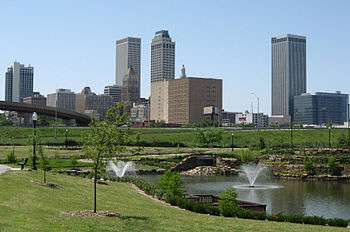 | |
|---|---|---|
| Principal city | ||
| Cities over 20k | ||
| Cities 10k-20k | ||
| Cities 5k-10k | ||
| Cities and towns 1k-5k | ||
Municipalities and communities of Osage County, Oklahoma, United States | ||
|---|---|---|
| Cities | 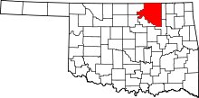 | |
| Towns | ||
| CDP | ||
| Unincorporated communities |
| |
| Footnotes | ‡This populated place also has portions in an adjacent county or counties | |