Barneveld, Wisconsin
| Barneveld, Wisconsin | |
|---|---|
| Village | |
 Location of Barneveld, Wisconsin | |
| Coordinates: 43°0′51″N 89°53′44″W / 43.01417°N 89.89556°WCoordinates: 43°0′51″N 89°53′44″W / 43.01417°N 89.89556°W | |
| Country | United States |
| State | Wisconsin |
| County | Iowa |
| Area[1] | |
| • Total | 1.94 sq mi (5.02 km2) |
| • Land | 1.94 sq mi (5.02 km2) |
| • Water | 0 sq mi (0 km2) |
| Elevation[2] | 1,227 ft (374 m) |
| Population (2010)[3] | |
| • Total | 1,231 |
| • Estimate (2012[4]) | 1,236 |
| • Density | 634.5/sq mi (245.0/km2) |
| Time zone | Central (CST) (UTC-6) |
| • Summer (DST) | CDT (UTC-5) |
| Area code(s) | 608 |
| FIPS code | 55-04775[5] |
| GNIS feature ID | 1561183[2] |
Barneveld is a village in Iowa County, Wisconsin, United States. The population was 1,231 at the 2010 census. It is part of the Madison Metropolitan Statistical Area.
The community was named for John of Barneveld of the Netherlands.[6]
Geography
Barneveld is located at 43°0′51″N 89°53′44″W / 43.01417°N 89.89556°W (43.014223, -89.895551).[7]
According to the United States Census Bureau, the village has a total area of 1.94 square miles (5.02 km2), all of it land.[1]
Demographics
| Historical population | |||
|---|---|---|---|
| Census | Pop. | %± | |
| 1910 | 317 | — | |
| 1920 | 289 | −8.8% | |
| 1930 | 301 | 4.2% | |
| 1940 | 358 | 18.9% | |
| 1950 | 373 | 4.2% | |
| 1960 | 420 | 12.6% | |
| 1970 | 528 | 25.7% | |
| 1980 | 579 | 9.7% | |
| 1990 | 660 | 14.0% | |
| 2000 | 1,088 | 64.8% | |
| 2010 | 1,231 | 13.1% | |
| Est. 2015 | 1,232 | [8] | 0.1% |
2010 census
As of the census[3] of 2010, there were 1,231 people, 457 households, and 331 families residing in the village. The population density was 634.5 inhabitants per square mile (245.0/km2). There were 477 housing units at an average density of 245.9 per square mile (94.9/km2). The racial makeup of the village was 98.2% White, 0.7% African American, 0.1% Native American, 0.2% Asian, 0.1% Pacific Islander, and 0.7% from two or more races. Hispanic or Latino of any race were 0.2% of the population.
There were 457 households of which 43.1% had children under the age of 18 living with them, 60.2% were married couples living together, 9.2% had a female householder with no husband present, 3.1% had a male householder with no wife present, and 27.6% were non-families. 22.1% of all households were made up of individuals and 9% had someone living alone who was 65 years of age or older. The average household size was 2.67 and the average family size was 3.16.
The median age in the village was 32.4 years. 30.5% of residents were under the age of 18; 5.5% were between the ages of 18 and 24; 34.2% were from 25 to 44; 21.5% were from 45 to 64; and 8.2% were 65 years of age or older. The gender makeup of the village was 49.1% male and 50.9% female.
2000 census
As of the census[5] of 2000, there were 1,088 people, 396 households, and 298 families residing in the village. The population density was 805.7 people per square mile (311.2/km²). There were 400 housing units at an average density of 296.2 per square mile (114.4/km²). The racial makeup of the village was 98.71% White, 0.28% African American, 0.37% Native American, 0.09% Asian, and 0.55% from two or more races. Hispanic or Latino of any race were 0.09% of the population.
There were 396 households out of which 43.2% had children under the age of 18 living with them, 60.4% were married couples living together, 8.8% had a female householder with no husband present, and 24.7% were non-families. Households made up of individuals numbered 22.2% and 9.1% had someone living alone who was 65 years of age or older. The average household size was 2.72 and the average family size was 3.16
In the village the population was spread out with 30.7% under the age of 18, 6.4% from 18 to 24, 39.8% from 25 to 44, 14.4% from 45 to 64, and 8.6% who were 65 years of age or older. The median age was 32 years. For every 100 females there were 107.2 males. For every 100 females age 18 and over, there were 1000 males
The median income for a household in the village was $56,000, and the median income for a family was $58,393. Males had a median income of $34,107 versus $25,480 for females The per capita income for the village was $22,009. About 4.7% of families and 7.5% of the population were below the poverty line, including 12.2% of those under age 18 and 5.5% of those age 65 or over
1984 F5 Tornado
At 12:41 AM CDT on June 8, 1984, a powerful tornado tore through Barneveld. It was part of a large outbreak of storms that started the evening before with tornadoes also touching down in Kansas, Missouri, Iowa, and Minnesota.[10] Although a tornado watch had been issued late on the night of June 7, most residents were unaware that a storm was approaching until they were awakened by a lightning strike and an instanteous clap of thunder just before 12:41 AM CDT. The 0.4-mile (0.60-km) wide tornado caused F5 damage, the highest level on the Fujita scale. Two hundred of the village's 584 residents were injured and nine were killed. Seventeen of the 18 businesses in Barneveld were destroyed, including all the government offices, the fire station, library, and post office. The town's three churches were all flattened: the Congregational United Church of Christ, pastor Rev. Jann Cather Weaver, the Lutheran Church, pastor Rev. Robert Twiton, and the Roman Catholic Church. The Congregational UCC church also lost its parsonage.[11] In all, about 170 of the village's 225 commercial, agricultural, and residential buildings were either destroyed instantly or damaged seriously enough that they were unable to be rebuilt. The only remaining and largely undamaged structure was the water tower, which had to be repaired and repainted. Damage to the village of Barneveld was estimated at $25 million with damage to the surrounding area put at about $40 million. Rebuilding began immediately, and by 2000, the population of Barneveld was almost exactly double what it was at the time the tornado nearly destroyed the town. The thunderstorm that created the tornado also put on one of the brightest lightning shows in recorded history, generating 200 strikes per minute.[12]
Images
-

1984 tornado damage
-

Looking west at Barneveld
-

Looking east at houses and Barneveld's water tower
-
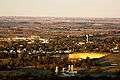
An aerial view from nearby Blue Mound State Park.
References
- 1 2 "US Gazetteer files 2010". United States Census Bureau. Archived from the original on January 24, 2012. Retrieved 2012-11-18.
- 1 2 "US Board on Geographic Names". United States Geological Survey. 2007-10-25. Retrieved 2008-01-31.
- 1 2 "American FactFinder". United States Census Bureau. Retrieved 2012-11-18.
- ↑ "Population Estimates". United States Census Bureau. Archived from the original on June 17, 2013. Retrieved 2013-06-24.
- 1 2 "American FactFinder". United States Census Bureau. Archived from the original on September 11, 2013. Retrieved 2008-01-31.
- ↑ Chicago and North Western Railway Company (1908). A History of the Origin of the Place Names Connected with the Chicago & North Western and Chicago, St. Paul, Minneapolis & Omaha Railways. p. 41.
- ↑ "US Gazetteer files: 2010, 2000, and 1990". United States Census Bureau. 2011-02-12. Retrieved 2011-04-23.
- ↑ "Annual Estimates of the Resident Population for Incorporated Places: April 1, 2010 to July 1, 2015". Retrieved July 2, 2016.
- ↑ "Census of Population and Housing". Census.gov. Archived from the original on May 11, 2015. Retrieved June 4, 2015.
- ↑ "June 8, 1984 Barneveld, WI F5 Tornado". National Weather Service. National Oceanic and Atmospheric Administration. Retrieved 31 July 2015.
- ↑ Weaver, Jann Cather. Interview. Unpublished.
- ↑ Extreme Weather. p. 188.
- www.channel3000.com Barneveld, 1984: 9 Dead, 200 Injured. WISC-TV Madison. June 9, 2004
External links
Municipalities and communities of Iowa County, Wisconsin, United States | ||
|---|---|---|
| Cities | 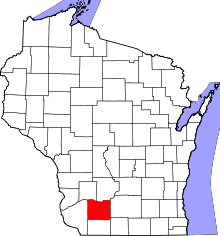 | |
| Villages | ||
| Towns | ||
| CDP | ||
| Unincorporated communities | ||
| Ghost towns | ||
| Footnotes | ‡This populated place also has portions in an adjacent county or counties | |