Barbourmeade, Kentucky
| Barbourmeade, Kentucky | |
|---|---|
| City | |
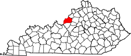
 Barbourmeade, Kentucky Location within the state of Kentucky | |
| Coordinates: 38°18′1″N 85°35′59″W / 38.30028°N 85.59972°WCoordinates: 38°18′1″N 85°35′59″W / 38.30028°N 85.59972°W | |
| Country | United States |
| State | Kentucky |
| County | Jefferson |
| Government5th class city | |
| • Type | Commission |
| • Mayor | Kim Holsclaw |
| Area | |
| • Total | 0.4 sq mi (1.1 km2) |
| • Land | 0.4 sq mi (1.1 km2) |
| • Water | 0.0 sq mi (0.0 km2) |
| Elevation | 630 ft (192 m) |
| Population (2000) | |
| • Total | 1,260 |
| • Density | 2,908.7/sq mi (1,123.1/km2) |
| Time zone | Eastern (EST) (UTC-5) |
| • Summer (DST) | EDT (UTC-4) |
| Area code(s) | 502 |
| FIPS code | 21-03556 |
| GNIS feature ID | 0486328 |
| Website | http://barbourmeade.org/ |
Barbourmeade is a home rule-class city[1] in Jefferson County, Kentucky, United States. It was formally incorporated by the state assembly in 1962.[2] The population was 1,260 at the 2000 census.
The community derives its name from Thomas and Richard Barbour, early settlers.[3] Barbourmeade incorporated as a city in 1962.[4]
Geography
Barbourmeade is located at 38°18′1″N 85°35′59″W / 38.30028°N 85.59972°W (38.300219, -85.599695).[5]
According to the United States Census Bureau, the city has a total area of 0.4 square miles (1.0 km2), all land.
Demographics
| Historical population | |||
|---|---|---|---|
| Census | Pop. | %± | |
| 1970 | 884 | — | |
| 1980 | 1,038 | 17.4% | |
| 1990 | 1,402 | 35.1% | |
| 2000 | 1,260 | −10.1% | |
| 2010 | 1,218 | −3.3% | |
| Est. 2015 | 1,258 | [6] | 3.3% |
As of the census[8] of 2000, there were 1,260 people, 506 households, and 400 families residing in the city. The population density was 2,908.7 people per square mile (1,131.4/km²). There were 516 housing units at an average density of 1,191.2 per square mile (463.3/km²). The racial makeup of the city was 95.87% White, 2.38% Black or African American, 0.95% Asian, 0.08% from other races, and 0.71% from two or more races. Hispanic or Latino of any race were 0.63% of the population.
There were 506 households out of which 30.4% had children under the age of 18 living with them, 72.7% were married couples living together, 5.1% had a female householder with no husband present, and 20.8% were non-families. 18.8% of all households were made up of individuals and 9.3% had someone living alone who was 65 years of age or older. The average household size was 2.49 and the average family size was 2.84.
In the city the population was spread out with 22.8% under the age of 18, 3.3% from 18 to 24, 19.8% from 25 to 44, 33.7% from 45 to 64, and 20.4% who were 65 years of age or older. The median age was 48 years. For every 100 females there were 92.1 males. For every 100 females age 18 and over, there were 90.0 males.
The median income for a household in the city was $71,711, and the median income for a family was $78,414. Males had a median income of $56,563 versus $36,458 for females. The per capita income for the city was $32,865. About 0.5% of families and 0.8% of the population were below the poverty line, including none of those under the age of eighteen or sixty-five or over.
References
- ↑ "Summary and Reference Guide to House Bill 331 City Classification Reform" (PDF). Kentucky League of Cities. Retrieved December 30, 2014.
- ↑ Commonwealth of Kentucky. Office of the Secretary of State. Land Office. "Barbourmeade, Kentucky". Accessed 15 Jul 2013.
- ↑ Rennick, Robert M. (1994). Kentucky Place Names. University Press of Kentucky. p. 13.
- ↑ "Kentucky Land Office database". Kentucky Secretary of State. Archived from the original on 2012-06-09. Retrieved 2011-11-17.
- ↑ "US Gazetteer files: 2010, 2000, and 1990". United States Census Bureau. 2011-02-12. Retrieved 2011-04-23.
- ↑ "Annual Estimates of the Resident Population for Incorporated Places: April 1, 2010 to July 1, 2015". Retrieved July 2, 2016.
- ↑ "Census of Population and Housing". Census.gov. Archived from the original on May 11, 2015. Retrieved June 4, 2015.
- ↑ "American FactFinder". United States Census Bureau. Archived from the original on September 11, 2013. Retrieved 2008-01-31.
| History |
|  |
|---|---|---|
| Geography |
| |
| Government |
| |
| Transportation | ||
| Other subject areas | ||
| Top subjects | ||
| National Historic Landmarks | ||
| Prominent suburbs (over 10K pop.) | ||
| ||