Banksia Park, South Australia
| Banksia Park Adelaide, South Australia | |||||||||||||
|---|---|---|---|---|---|---|---|---|---|---|---|---|---|
 Banksia Park streetscape | |||||||||||||
| Population | |||||||||||||
| • Density | 635/km2 (1,644/sq mi) | ||||||||||||
| Postcode(s) | 5091 | ||||||||||||
| Area | 5.1 km2 (2.0 sq mi) | ||||||||||||
| Location | 20 km (12 mi) from Adelaide | ||||||||||||
| LGA(s) | City of Tea Tree Gully | ||||||||||||
| State electorate(s) | Electoral district of Newland | ||||||||||||
| Federal Division(s) | Division of Makin | ||||||||||||
| |||||||||||||
Banksia Park is a north-eastern suburb located 20 km from the city centre of Adelaide, South Australia, within the City of Tea Tree Gully.
History
Banksia Park was originally named Steventon by John Stevens, the first purchaser of this block of land, however the name was later changed to Banksia Park due to the abundance of banksia trees located within the area.
Steventon Post Office opened around January 1859 and was renamed Tea Tree Gully in 1872. A Banksia Park office has never existed.[3]
Residents
In 2001, Banksia Park had a population of 3,455 with 48% being in the age group of 25–54 years.[4] By 2006, the population dropped to 3,398[2] and by 2011, it has dropped to 3,238.[1]
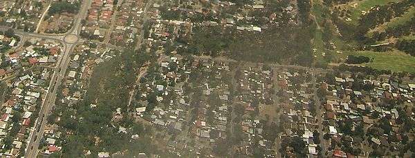
Aerial image of the northwestern part of Banksia Park, looking north. Hancock Road is the north-south road visible on the left-hand side of the image, and Grenfell Road is the east-west road. They intersect at the roundabout in the top-left hand corner. Banksia Park is the area southeast of the roundabout. The green region to the top right is part of Tea Tree Gully Golf Course.
References
- 1 2 Australian Bureau of Statistics (31 October 2012). "Banksia Park (State Suburb)". 2011 Census QuickStats. Retrieved 14 February 2015.
- 1 2 Australian Bureau of Statistics (25 October 2007). "Banksia Park (State Suburb)". 2006 Census QuickStats. Retrieved 17 July 2010.
- ↑ Premier Postal History. "Post Office List". Premier Postal Auctions. Retrieved 26 May 2011.
- ↑ Australian Bureau of Statistics (9 March 2006). "Banksia Park (State Suburb)". 2001 Census QuickStats. Retrieved 17 July 2010.
Coordinates: 34°48′S 138°44′E / 34.800°S 138.733°E
This article is issued from Wikipedia - version of the 4/4/2016. The text is available under the Creative Commons Attribution/Share Alike but additional terms may apply for the media files.