Awatere River
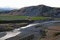
The Awatere River is a large river flowing through Marlborough, New Zealand. Flowing along the trace of the active Awatere Fault, it runs northeast through a straight valley to the west of the Inland Kaikoura mountains. This valley is parallel with that of the Clarence River, 20 kilometres (12 mi) to the south.
It flows for 110 kilometres (68 mi) from its source in the mountainous interior to reach Cook Strait close to the town of Seddon.
Awatere River bridge
In 1887 the Awatere River was without any bridge crossing and at the time was noted by Parliament to be the only river not bridged between Picton and Bluff. Planning of a 325-metre joint road and rail bridge began in 1896, designed by Peter Seton Hay, and construction by Scott Brothers Ltd, a Christchurch based company, began two years after. Back in those times, bridge building lacked the modern engineering technology that is used today, and much of the construction was done via human and animal power. The laying of caissons which formed the foundations of the bridge was notoriously treacherous to workers at the risk of developing the bends due to long exposure of working in pressurised conditions. Construction was completed on 18 July 1901.[1] The original road/rail bridge was opened on 10 October 1902. Construction took three years at the cost of £22,500.[2]
State Highway 1 crosses the Awatere River at its current point just north of Seddon. The initial bridge remained the crossing until 2007 when most recently traffic signals were added to either direction to control vehicles on the platform, which was only wide enough for one lane of traffic. A new $15 million two-lane road bridge was constructed with the railway being the sole use of the original bridge and officially opened on 9 November 2007. The vehicle deck on the original bridge was decommissioned as it was deemed too expensive to retain its use for pedestrians and cyclists.[3]
References
- ↑ Dr Roger Hanson (7 June 2016). "Awatere River bridge brought nose bleeds, black outs and risk of 'the bends'". Retrieved 7 June 2016.
- ↑ "Awatere Road Rail Bridge 1902 to 2007". Retrieved 7 March 2016.
- ↑ "New Awatere Bridge opens today". 9 November 2007.
External links
Coordinates: 41°36′29″S 174°10′01″E / 41.608°S 174.167°E