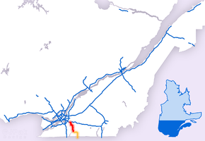
Quebec Autoroute 35
| ||||
|---|---|---|---|---|
| Autoroute de la Vallée-des-Forts | ||||
 | ||||
| Route information | ||||
| Maintained by Transports Québec | ||||
| Length: | 40.0 km[1][2][3] (24.9 mi) | |||
| Existed: | 1966[3] – present | |||
| Major junctions | ||||
| South end: |
| |||
|
| ||||
| North end: |
| |||
| Location | ||||
| Major cities: | Saint-Jean-sur-Richelieu | |||
| Highway system | ||||
| ||||

Autoroute 35 (A-35) is an Autoroute in the region of Montérégie, Quebec, Canada. Constructed in the 1960s, the A-35 links Saint-Jean-sur-Richelieu with Montreal via the A-10. The A-35 is also the primary route for traffic between Montreal and Boston, although it ends 13.4 km (8.3 mi) short of the U.S. border. South of its current terminus in Saint-Sébastien, the A-35 continues as two-lane Route 133 (which becomes four-lane divided 6.5 km (4.0 mi) north of the border) to the border. An extension of A-35 to meet Interstate 89 at Saint-Armand will complete a nearly 500 km (310.7 mi) limited-access highway link between Montreal and Boston.[4] It had been scheduled to open in 2017, but construction is on hold during 2015 and 2016, so this last freeway link is delayed until at least 2020. The MTQ has not mentioned any revised schedule.
Like many Quebec Autoroutes, the A-35 also has a name: Autoroute de la Vallée-des-Forts (Forts Valley Highway). The name refers to a chain of forts built by the French in the Richelieu Valley during the 17th and 18th centuries to defend their colonial settlements from the Iroquois. Previously, the A-35 was known as Autoroute de la Nouvelle-Angleterre (New England Motorway), referring to its role as a link between Quebec and New England.
History
First constructed in the 1960s, A-35 is currently a 40 km (24.9 mi) long, 4-lane spur route linking Saint-Jean-sur-Richelieu to Autoroute 10. By 1966, 16 km (9.9 mi) connecting the A-10 in Chambly with Route 104 in Iberville were opened to traffic. Another 3 km (1.9 mi) of A-35 from Route 104 to its terminus with Route 133 were completed in 1967. Completion of the entire length of A-35 had been scheduled for that year in time for Expo 67, but the province instead focused on expediting construction of autoroutes and approach roads to the Expo site.[5]
For many years, the A-35 featured at-grade intersections with St-Raphael Road and St-Andre Road in Saint-Luc. These intersections were closed in 1999; the St-Andre Road intersection was converted into a partial cloverleaf interchange, while St-Raphael Road was dead-ended on either side of the A-35.
Future
A federal-provincial funding agreement is providing for the completion of the A-35 to Interstate 89 at the U.S. border. The project's objectives are to improve economic links between Quebec and New England, reduce traffic on Route 133 (which is ill-equipped for the traffic it currently carries), and improve quality of life in the region.[4]
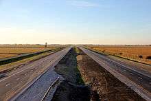
Construction of the A-35 extension began in 2009 between Saint-Alexandre and Saint-Sébastien. Construction of the 37.9 km extension is divided into four segments. The first section (first two segments) of new highway between Saint-Jean-sur-Richelieu and Highway 133 to Saint-Sébastien was opened October 8th, 2014. Although as recently as 2012 it was expected that the entire extension would be open to traffic in 2017, no further construction is planned during 2015 and 2016, which means that 2020 or later is the new expectation. If ever completed, the length of A-35 will increase to 55 km (34.2 mi).
Exit list
Interchanges are listed from south to north.
| RCM or ET | Municipality | km | No. | Destinations | Notes |
|---|---|---|---|---|---|
| Continues into Vermont as | |||||
| Brome-Missisquoi | Saint-Armand | 0 | Canada–US border | Future southern terminus of | |
| 3 | Saint-Armand south exit (Chemin de St-Armand) | Future Exit | |||
| 6 | Future Exit | ||||
| Le Haut-Richelieu | Saint-Sébastien | 14.81 | 15 | Opened Oct. 2014 | |
| Saint-Alexandre | (28) | (proposed in original plans) | |||
| Saint-Jean-sur-Richelieu | 35.50 | 36 | Grande-Ligne exit (Chemin de la Grande-Ligne) | Opened Oct. 2014 | |
| 37.61 | 38 (was 1) | ||||
| 39.18 | 39 (was 3) | Eastern terminus of | |||
| 42.21 | 42 (was 6) | ||||
| 43.55 | 43 (was 7) | ||||
| 44.88 | 45 (was 9) | ||||
| 46.64 | 47 (was 11) | Western terminus of | |||
| 50.52 | 50 (was 14) | Chemin St-André | |||
| Carignan-Chambly boundary | 54.99 | 55 (was 18) | |||
| Northern terminus of Roadway continues north as Boulevard Fréchette. | |||||
References
- ↑ Ministère des transports, "Distances routières", page (?), Les Publications du Québec, 2005
- ↑ A-35 at Exitlists.com
- 1 2 "Répertoire des autoroutes du Québec" (in French). Transports Québec. Retrieved 2008-02-23.
- 1 2 "Autoroute 35 - Extension" (in French). Transports-Quebec. Retrieved 25 February 2012.
- ↑ "Vallee des Forts Autoroute". MontrealRoads.net. Retrieved 25 February 2012.
External links
| Wikimedia Commons has media related to Quebec Autoroute 35. |
- A-35 at Quebec Autoroutes
- Vallee des Forts Autoroute (A-35) at Steve Anderson's montrealroads.com
- Autoroute de la Vallée-des-Forts (35) - Prolongement(MTQ / Transports Québec) (French)
- New exit numbers for Autoroute 35 (French)