Chambly, Quebec
| Chambly | |
|---|---|
| City | |
|
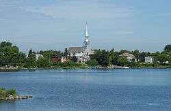
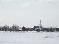
Chambly's Church St-Joseph, viewed from the Basin. | |
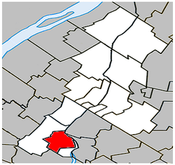 Location within La Vallée-du-Richelieu RCM. | |
 Chambly Location in southern Quebec. | |
| Coordinates: 45°27′N 73°17′W / 45.450°N 73.283°WCoordinates: 45°27′N 73°17′W / 45.450°N 73.283°W[1] | |
| Country |
|
| Province |
|
| Region | Montérégie |
| RCM | La Vallée-du-Richelieu |
| Constituted | October 26, 1849 |
| Amalgamated | September 18, 1965 |
| Government[2][3] | |
| • Mayor | Denis Lavoie |
| • Federal riding | Beloeil—Chambly |
| • Prov. riding | Chambly |
| Area[2][4] | |
| • Total | 27.60 km2 (10.66 sq mi) |
| • Land | 25.11 km2 (9.70 sq mi) |
| Population (2011)[4] | |
| • Total | 25,571 |
| • Density | 1,018.2/km2 (2,637/sq mi) |
| • Pop 2006-2011 |
|
| • Dwellings | 10,093 |
| Time zone | EST (UTC−5) |
| • Summer (DST) | EDT (UTC−4) |
| Postal code(s) | J3L |
| Area code(s) | 450 and 579 |
| Highways |
|
| Website |
www |
Chambly is a city in southwestern Quebec, Canada, about 25 km (16 mi) to the south east of Montreal.
It was formed from the merger in 1965 of Fort-Chambly (formerly Chambly-Canton prior to 1952) and the old city of Chambly (formerly Chambly-Bassin prior to 1952, and earlier sometimes called Bassin-de-Chambly).
Geography
It sits on the Richelieu River in the Regional County Municipality of La-Vallée-du-Richelieu, at 45°27′00″N 73°17′27″W / 45.45000°N 73.29083°W.
History
People have lived in Chambly since the 17th century, but Chambly was not incorporated as a city until 1965.
Samuel de Champlain passed through the area that came to be the site of the town of Chambly, QC, in 1609., when he wrote the following in his journal:
The approach to the rapids is a sort of lake into which the water flows down, and it is about three leagues in circumference. Near by are meadows were no Indians live, by reason of the wars. At the rapids there is very little water, but it flows with great swiftness, and there are many rocks and boulders, so that the Indians cannot go up by water; but on the way back they run them very nicely. All this region is very level and full of forests, vines and butternut trees. No Christian has ever visited this land and we had all the misery of the world trying to paddle the river upstream.
The College of Chambly was chartered on March 21, 1835 in Lower Canada.[5]
Fort Chambly
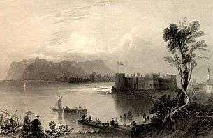
Chambly is home to the massive Fort Chambly, built with local stone between 1709 and 1711 in the style of Vauban's classic French fortifications. It was built at the mouth of a large basin, on the site of successive wooden forts dating back to 1665. Fort Chambly was the largest in a series of fortifications on the shores of what was known as the Iroquois River (later known as the Chambly River, finally becoming the Richelieu River in the nineteenth century). Originally called Fort Saint-Louis, it soon came to be known by the name of its first commanding officer, Jacques de Chambly, to whom the surrounding seigniory was granted in 1672. It was intended to protect New France in general (and Montreal in specific) from attack from hostile natives and the English. Today, the fort is run by Parks Canada and is designated a National Historic Site of Canada, and houses a museum and interpretive center, and hosts historical re-enactments of military drills (as well as a number of contemporary cultural events).
A small local population clustered around the fort, and the entire area eventually became known as Chambly as well.
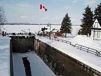
Chambly Canal
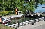
Chambly is also known for the Chambly Canal, a National Historic Site run by Parks Canada. It was built in 1843 to bypass several kilometers of successive Richelieu River rapids between the towns of Chambly, QC, and Saint-Jean-sur-Richelieu. Part of a series of waterways connecting the Saint Lawrence River and New York City, Chambly Canal was built to facilitate commercial traffic between Canada and the United States.
Trade dwindled after World War I, and as of the 1970s, traffic has been replaced by recreational vessels. Today the canal is enjoyed by tourists and more than 7,000 pleasure boats in the summer, and ice skaters in the winter.
The St-Joseph of Chambly church is located at 164 Martel street. It was built between 1880 and 1881. The parish was founded in 1665.
Demographics
The population as of the Canada 2011 Census was 25,571. Although mostly populated today by French Canadians, Chambly has long had a vibrant English citizenry.
PopulationPopulation trend:[6]
|
LanguageMother tongue language (2006)[7]
|
Economy
Business
As of 2015, Chambly's largest local employers are:[8]
- Les Aliments Cargill
- Kraft Canada inc.
- Marché Lambert et Frères inc. (IGA)
- Métro Collin inc.
- Ostiguy et Frères Inc. (BMR Group)
- Sleeman Unibroue inc. (Unibroue)
- JG Rive-Sud Fruits & Légumes
- Maçonnerie Rainville & Frères Inc.
- JER-B Syl inc. Division | Kkwit.com
- Dicom Express Inc.
- Manoir Soleil inc.
- Remtec inc.
- Fondrémy inc.
- Fourquet Fourchette
- Restaurant Tre Colori
- T.A.S. Techno Aero Services Inc.
- Maçonnerie Pro-Conseil inc.
- ISAAC Instruments inc.
- Zone Technologie Électrique Inc.
- Caisse populaire Desjardins du Bassin-de-Chambly (Desjardins Group)
- Chambly Honda http://chamblyhonda.com (Group Chambly)
Transportation
The CIT Chambly-Richelieu-Carignan provides commuter and local bus services.
Education
In English, the South Shore Protestant Regional School Board[9] and later the Richelieu Valley School Board[10] previously served the municipality. Currently Chambly is served by the Riverside School Board and specifically by William Latter Elementary School.
In French, the Commission scolaire des Patriotes serves Chambly, with the following schools located in the municipality:
- École De Bourgogne (Elementary)
- École De Salaberry (Elementary)
- École Jacques-De Chambly (Elementary)
- École Sainte-Marie (Elementary)
- Nouvelle école de Chambly (Elementary - Open but not yet named[11])
- École secondaire de Chambly (Secondary 1, 2 and 3)
Media
Chambly is currently served by a local weekly newspaper called the "Journal de Chambly", first published in 1966.
A small daily news sheet called Chambly Matin also maintains a journalistic presence on the internet reporting on local issues.
Notable people
See also
References
| Wikimedia Commons has media related to Chambly (Québec). |
- ↑ Reference number 98647 of the Commission de toponymie du Québec (French)
- 1 2 Ministère des Affaires municipales, des Régions et de l'Occupation du territoire: Chambly
- ↑ Parliament of Canada Federal Riding History: CHAMBLY--BORDUAS (Quebec)
- 1 2 2011 Statistics Canada Census Profile: Chambly, Quebec
- ↑ Pound, Richard W. (2005). 'Fitzhenry and Whiteside Book of Canadian Facts and Dates'. Fitzhenry and Whiteside.
- ↑ Statistics Canada: 1996, 2001, 2006, 2011 census
- ↑ 2006 Statistics Canada Community Profile: Chambly, Quebec
- ↑ Répertoire des entreprises. Ville de Chambly. 2015. http://www.ville.chambly.qc.ca/index.php/affaires-2/repertoire-des-entreprises/
- ↑ King, M.J. (Chairperson of the board). "South Shore Protestant Regional School Board" (St. Johns, PQ). The News and Eastern Townships Advocate. Volume 119, No. 5. Thursday December 16, 1965. p. 2. Retrieved from Google News on November 23, 2014.
- ↑ https://news.google.com/newspapers?nid=1251&dat=19750805&id=VpNTAAAAIBAJ&sjid=9IcDAAAAIBAJ&pg=3556,1475069
- ↑ Baillargeon, Annabelle. "Nouvelle école de Chambly: à la recherche de sa vraie couleur", Journal de Chambly, Chambly, September 1st, 2016. Retrieved on November 1st, 2016.
External links
- Town of Chambly website
- Fort Chambly page at Parks Canada website
- Chambly Canal page at Parks Canada website
 |
Saint-Mathias-sur-Richelieu | | ||
| Carignan | |
Richelieu Carignan | ||
| ||||
| | ||||
| Saint-Jean-sur-Richelieu |
| Cities | |
|---|---|
| Municipalities | |
| |