Arkansas Highway 368
| ||||
|---|---|---|---|---|
| Route information | ||||
| Maintained by AHTD | ||||
| Length: | 6.90 mi[1] (11.10 km) | |||
| Major junctions | ||||
| South end: |
| |||
| North end: |
| |||
| Location | ||||
| Counties: | Nevada, Ouachita | |||
| Highway system | ||||
| ||||

Arkansas Highway 368 (AR 368) is an east–west state highway in South Arkansas. The route of 6.90 miles (11.10 km) runs essentially as a northern loop of Arkansas Highway 24 through Reader while Highway 24 runs more southerly through Bluff City.[2] This connects the community of Reader to the state highway system.
Route description
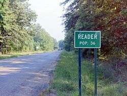
Arkansas Highway 368 enters Reader.
Highway 368 begins at Arkansas Highway 24 in Nevada County east of Prescott and runs east to Reader. The route passes the Reader Railroad Depot and Reader Park before it turns south after an intersection with Main Street.[3] It terminates after running through forest land at Arkansas Highway 24.
Major intersections
| County | Location | mi[1] | km | Destinations | Notes |
|---|---|---|---|---|---|
| Nevada | | 0.00 | 0.00 | ||
| Ouachita | | 6.90 | 11.10 | ||
| 1.000 mi = 1.609 km; 1.000 km = 0.621 mi | |||||
References
- 1 2 Planning and Research Division (2010). "Arkansas Road Log Database". Arkansas State Highway and Transportation Department. Archived from the original (Database) on 23 June 2011. Retrieved June 9, 2011.
- ↑ General Highway Map (PDF) (Map) (Navada County ed.). Arkansas State Highway and Transportation Department. Archived (PDF) from the original on 18 July 2011. Retrieved August 17, 2011.
- ↑ Map of Reader, Nevada and Ouachita Counties, Arkansas (PDF) (Map) (Green Forest, Arkansas ed.). Arkansas State Highway and Transportation Department, Planning and Research Division. October 2002. Retrieved 2011-08-17.
This article is issued from Wikipedia - version of the 10/18/2016. The text is available under the Creative Commons Attribution/Share Alike but additional terms may apply for the media files.