Arkansas Highway 298
| ||||
|---|---|---|---|---|
 | ||||
| Route information | ||||
| Maintained by AHTD | ||||
| Section 1 | ||||
| Length: | 3.71 mi[1] (5.97 km) | |||
| West end: |
| |||
| East end: |
| |||
| Section 2 | ||||
| Length: | 28.39 mi[1] (45.69 km) | |||
| West end: |
| |||
| East end: |
| |||
| Section 3 | ||||
| Length: | 13.81 mi[1] (22.23 km) | |||
| West end: |
| |||
| East end: |
| |||
| Highway system | ||||
| ||||

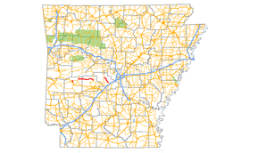
Highway 298 (AR 298, Ark. 298, and Hwy. 298) is a designation for three state highways in Lower Arkansas. The eastern segment of 3.71 miles (5.97 km) begins at Sims at Highway 88 and runs southeast to US Route 270 (US 270). A middle segment of 28.39 miles (45.69 km) runs from Highway 27 at Story east to Highway 7.[1] A segment in Saline County of 13.81 miles (22.23 km) runs east from Highway 9 to Highway 5 near Benton.[2]
Route description
Sims to Highway 270
The route begins at a junction with Arkansas Highway 88 at Sims and runs southeast to US 270. This segment does not cross or concur with any other state highways.
Story to Highway 7
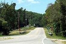
The route begins at Arkansas Highway 27 at Story, Arkansas in Montgomery County and runs east through the Ouachita National Forest for almost its entire length.[3] Highway 298 passes through very wooded area with sparse populations, crossing over many feeder streams for Lake Ouachita. The highway ends at a junction with Arkansas Highway 7 north of Hot Springs.[4]
Saline County
The Saline County routing begins at Arkansas Highway 9 in unincorporated Saline County and runs southeast through Bland and Grape before terminating at Arkansas Highway 5 approximately 1 mile (1.6 km) north of Benton.
Major intersections
| County | Location | mi[1] | km | Destinations | Notes |
|---|---|---|---|---|---|
| Montgomery | Sims | 0.00 | 0.00 | Western terminus | |
| | 3.71 | 5.97 | Eastern terminus | ||
| Highway 298 begins in Story | |||||
| Story | 0.00 | 0.00 | Western terminus | ||
| Garland | | 28.39 | 45.69 | Eastern terminus | |
| Highway 298 begins at Highway 5 | |||||
| Saline | | 0.00 | 0.00 | Eastern terminus | |
| | 13.81 | 22.23 | Western terminus | ||
| 1.000 mi = 1.609 km; 1.000 km = 0.621 mi | |||||
See also
-
 Arkansas portal
 -
 U.S. Roads portal
References
- 1 2 3 4 5 Planning and Research Division (2010). "Arkansas Road Log Database". Arkansas State Highway and Transportation Department. Archived from the original (Database) on 23 June 2011. Retrieved June 9, 2011.
- ↑ Route and Section Map (PDF) (Map) (Saline County ed.). Arkansas State Highway and Transportation Department. Retrieved October 8, 2011.
- ↑ General Highway Map (PDF) (Map) (Montgomery County ed.). Arkansas State Highway and Transportation Department. Retrieved October 8, 2011.
- ↑ General Highway Map (PDF) (Map) (Garland County ed.). Arkansas State Highway and Transportation Department. Retrieved October 8, 2011.