Arkansas Highway 201
| ||||
|---|---|---|---|---|
 | ||||
| Route information | ||||
| Maintained by AHTD | ||||
| Length: | 24.05 mi[1] (38.70 km) | |||
| Existed: | July 10, 1957[2] – present | |||
| Major junctions | ||||
| South end: |
| |||
|
| ||||
| North end: |
| |||
| Location | ||||
| Counties: | Baxter | |||
| Highway system | ||||
| ||||

Highway 201 (AR 201, Ark. 201, and Hwy. 201) is a north–south state highway in Baxter County, Arkansas. The route runs 24.05 miles (38.70 km) from Arkansas Highway 341 in Salesville north to the Missouri state line through Mountain Home, the county seat of Baxter County.[3]
Route description
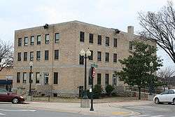
AR 201 begins in Salesville at Push Mountain Road. The highway runs west to Shady Grove, when it curves north to Mountain Home. Upon reaching Mountain Home, AR 201 intersects US 62/US 412 before the lone AR 201 spur leaves the main route. AR 201 continues north as S College Street past the Casey House until intersecting 9th Street.[4] A concurrency forms east then north through downtown Mountain Home. AR 5/AR 201 intersect and follow US 62B for six blocks north, passing the Mountain Home Commercial Historic District and Baxter County Courthouse, both on the National Register of Historic Places.[5] The routes run together as Hickory Street when AR 5/AR 201 branch west and US 62B stays east. Shortly after this fork, AR 201 departs AR 5 and heads due north. The highway runs through north Mountain Home and exits town, becoming a winding rural route. AR 201 runs through the unincorporated community of Clarkridge near the Missouri state line, when the road becomes state supplemental route J.[3]
History
The first portion of Highway 201 was from Mountain Home to Missouri, and was designated on July 10, 1957.[2] The highway was entirely gravel.[6] The southern half of this segment was paved in 1961.[7] The highway was extended south to Salesville in 1963.[8] The entire northern segment was paved to the Missouri state line the following year.[9] The entire southern portion was paved by 1979.[1]
Major intersections
Mile markers reset at concurrencies. The entire route is in Baxter County.
| Location | mi[3] | km | Destinations | Notes | |
|---|---|---|---|---|---|
| Salesville | 0.0 | 0.0 | Southern terminus | ||
| Mountain Home | 10.0 | 16.1 | |||
| 10.5 | 16.9 | AR 201S northern terminus | |||
| 11.5 | 18.5 | AR 5 concurrency north | |||
| 0.8 miles (1.3 km) concurrency north with | |||||
| 0.0 | 0.0 | AR 5 concurrency ends | |||
| Clarkridge | 12.6 | 20.3 | Northern terminus | ||
1.000 mi = 1.609 km; 1.000 km = 0.621 mi
| |||||
Mountain Home spur
| |
|---|---|
| Location: | Mountain Home |
| Length: | 0.25 mi[1] (0.40 km) |
| Existed: | 1975[1]–present |
Arkansas Highway 201 Spur is a spur route of 0.25-mile (0.40 km) in Mountain Home.[1]
See also
-
 Arkansas portal
 -
 U.S. Roads portal
References
- 1 2 3 4 5 "[Arkansas] State Highways 2009 (Database)." April 2010. AHTD: Planning and Research Division. Database. Retrieved March 15, 2011.
- 1 2 "Minutes of the Meeting" (PDF). Arkansas State Highway Commission. July 10, 1957. p. 1778. Retrieved January 29, 2013.
- 1 2 3 General Highway Map - Baxter County, Arkansas (PDF) (Map) (4/27/07 ed.). Arkansas State Highway and Transportation Department. Retrieved March 15, 2011.
- ↑ Map of Mountain Home, Baxter County, Arkansas (PDF) (Map) (November 2002 ed.). Arkansas State Highway and Transportation Department. Retrieved March 15, 2011.
- ↑ National Park Service (2010-07-09). "National Register Information System". National Register of Historic Places. National Park Service.
- ↑ State Highway Map - State of Arkansas (Map) (1959 ed.). Arkansas State Highway Department. Archived from the original on March 13, 2012. Retrieved March 15, 2011.
- ↑ State Highway Map - State of Arkansas (Map) (1962 ed.). Arkansas State Highway Department. Retrieved March 15, 2011.
- ↑ State Highway Map - State of Arkansas (Map) (1964 ed.). Arkansas State Highway Department. Retrieved March 15, 2011.
- ↑ State Highway Map - State of Arkansas (Map) (1965 ed.). Arkansas State Highway Department. Archived from the original on July 7, 2011. Retrieved March 15, 2011.