Pak Phayun District
| Pak Phayun ปากพะยูน | |
|---|---|
| Amphoe | |
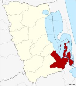 Amphoe location in Phatthalung Province | |
| Coordinates: 7°20′30″N 100°19′0″E / 7.34167°N 100.31667°ECoordinates: 7°20′30″N 100°19′0″E / 7.34167°N 100.31667°E | |
| Country |
|
| Province | Phatthalung |
| Seat | Pak Phayun |
| Area | |
| • Total | 433.3 km2 (167.3 sq mi) |
| Population (2008) | |
| • Total | 50,052 |
| • Density | 115.3/km2 (299/sq mi) |
| Time zone | THA (UTC+7) |
| Postal code | 93120 |
| Geocode | 9306 |
Pak Phayun (Thai: ปากพะยูน, pronounced [pàːk pʰā.jūːn]) is a district (Amphoe) of Phatthalung Province, southern Thailand.
Geography
Neighboring districts are (from the west clockwise) Pa Bon and Bang Kaeo of Phatthalung Province, Krasae Sin, Sathing Phra, Singhanakhon and Khuan Niang of Songkhla Province.
To the east of the district is the Thale Luang lake, which through a narrow strait opens into the main Songkhla Lake south of the district.
History
The district was established in 1896 as part of the thesaphiban administrative reforms, originally subdivided into 17 tambon.
In 1903 it was renamed from Taksin (ทักษิณ, meaning South) to Pak Phayun.[1]
Administration
The district is subdivided into 7 subdistricts (tambon), which are further subdivided into 63 villages (muban). Pak Phayun is a subdistrict municipality (thesaban tambon) which covers parts of tambon Pak Phayun. There are further 7 Tambon administrative organizations (TAO).
| No. | Name | Thai | Villages | Inh.[2] |
|---|---|---|---|---|
| 1. | Pak Phayun | ปากพะยูน | 6 | 8,609 |
| 2. | Don Pradu | ดอนประดู่ | 11 | 6,416 |
| 3. | Ko Nang Kham | เกาะนางคำ | 9 | 5,503 |
| 4. | Ko Mak | เกาะหมาก | 11 | 7,029 |
| 5. | Falami | ฝาละมี | 11 | 10,613 |
| 6. | Han Thao | หารเทา | 9 | 9,506 |
| 7. | Don Sai | ดอนทราย | 6 | 2,376 |
References
- ↑ แจ้งความกระทรวงมหาดไทย (PDF). Royal Gazette (in Thai). 19 (52): 1010. 1903-03-15.
- ↑ "Population statistics 2008". Department of Provincial Administration.
External links
- amphoe.com (Thai)