Pa Mok District
| Pa Mok ป่าโมก | |
|---|---|
| Amphoe | |
|
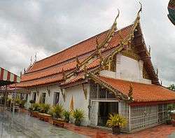
Viharn of the Reclining Buddha at Wat Pa Mok | |
 Amphoe location in Ang Thong Province | |
| Coordinates: 14°29′24″N 100°26′53″E / 14.49000°N 100.44806°ECoordinates: 14°29′24″N 100°26′53″E / 14.49000°N 100.44806°E | |
| Country |
|
| Province | Ang Thong |
| Area | |
| • Total | 80.9 km2 (31.2 sq mi) |
| Population (2000) | |
| • Total | 28,140 |
| • Density | 350/km2 (900/sq mi) |
| Time zone | THA (UTC+7) |
| Postal code | 14130 |
| Geocode | 1503 |
Pa Mok (Thai: ป่าโมก) is the southernmost district (Amphoe) of Ang Thong Province, central Thailand.
History
This area was called Ban Pa Mok Noi. In 1585 King Naresuan the Great set his military camp in the area.[1]:102 Before moving his troops to fight with Burmese troops of Phra Maha Uparacha at Don Chedi, he saluted the big Reclining Buddha in Pa Mok. And he won the war. During the reign of King Thai sa, he was the leader of workers who moved the Reclining Buddha to save it from flooding.
Pa Mok district was separated from Mueang Ang Thong district and upgraded to a full district in 1902. The first district office was finished in 1904.
Geography
Neighboring districts are (from the north clockwise) Wiset Chai Chan and Mueang Ang Thong of Ang Thong Province, and Maha Rat, Bang Pahan, Bang Ban and Phak Hai of Ayutthaya Province.
Administration
The district is subdivided into 8 subdistricts[2] (tambon). The township (thesaban tambon) Pa Mok covers the complete tambon Pa Mok and Bang Pla Kot.
| No. | Name | Thai |
|---|---|---|
| 1. | Bang Pla Kot | บางปลากด |
| 2. | Pa Mok | ป่าโมก |
| 3. | Sai Thong | สายทอง |
| 4. | Rong Chang | โรงช้าง |
| 5. | Bang Sadet | บางเสด็จ |
| 6. | Norasing | นรสิงห์ |
| 7. | Ekkarat | เอกราช |
| 8. | Phong Pheng | โผงเผง |
References
- ↑ Rajanubhab, D., 2001, Our Wars With the Burmese, Bangkok: White Lotus Co. Ltd., ISBN 9747534584
- ↑ "Ma Pok District". Asia Property World. Retrieved 7 January 2013.