Naghnaghiya
| Naghnaghiya | |
|---|---|
 Naghnaghiya | |
| Arabic | النغْنغية |
| Also spelled | Al-Naghnaghiyya |
| Subdistrict | Haifa |
| Coordinates | 32°36′12.2″N 35°09′26.9″E / 32.603389°N 35.157472°ECoordinates: 32°36′12.2″N 35°09′26.9″E / 32.603389°N 35.157472°E |
| Palestine grid | 164/223 |
| Population | 416[1] (1931) |
| Area | 12,139 dunams |
| Date of depopulation | 12-13 April 1948[2] |
| Cause(s) of depopulation | Military assault by Yishuv forces |
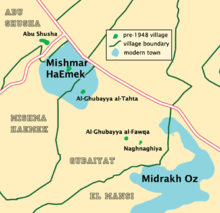
Naghnaghiya (Arabic: النغْنغية, Al-Naghnaghiyya) was a Palestinian Arab village, 28.5 kilometers (17.7 mi) southeast of Haifa.[3] It was depopulated before the outbreak of the 1948 Arab-Israeli war.[4]
Location
The village was on the north edge of a hill at the edge of a wadi bed, overlooking the Jezreel Valley and the Nazareth hills to the north and northeast. It was the smallest of a group of three villages (known collectively as al-Ghubayyat) located together; the others were Al-Ghubayya al-Fawqa and Al-Ghubayya al-Tahta. Next to al- Naghnaghiya was an artificial mound that bore the same name. Two kilometers to the southeast, on the highway to Jenin was Tall al-Mutasallim, identified with Megiddo.[3]
History
In 1888, during Ottoman rule, an elementary school was built that was shared by the three al-Ghubayyat villages.[3]
British Mandate era
In the British Mandate of Palestine period, in the 1922 census of Palestine Al Naghnaghiyeh had a population of 272; all Muslims,[5] increasing in the 1931 census to 416, still all Muslims, in a total of 78 houses.[1]
In 1945 the population of Al-Ghubayya al-Fawqa, Al-Ghubayya al-Tahta and Naghnaghiya was 1,130, all Muslims,[6] and it had 12,139 dunams of land according to an official land and population survey.[7] 209 dunams were for plantations and irrigable land, 10,883 for cereals,[8] while no data were given for built-up (urban) land.[9]
1948, and after
Before the outbreak of the 1948 Arab-Israeli war, on the night of the 12-13 April 1948, Naghnaghiya and the neighbouring village of al-Mansi were attacked by the Palmach, a Jewish militia.[4] By 15 April, both villages had been depopulated, and they were then blown up by the Jewish militia forces in order to block the return of the villagers.[10]
According to the Palestinian historian Walid Khalidi, describing the village in 1992: "The remains of houses are scattered on the slope of one hill. The site, traversed by the Haifa-Megiddo highway and partly occupied by an Israeli soccer field, is difficult to identify."[11]
See also
- Battle of Mishmar HaEmek
- List of Arab towns and villages depopulated during the 1948 Arab-Israeli War
References
- 1 2 Mills, 1932, p. 95
- ↑ Morris, 2004, p. xviii village #149. Also gives cause of depopulation
- 1 2 3 Khalidi, 1992, p. 179
- 1 2 Morris, 2004, p. 242
- ↑ Barron, 1923, Table XI, Sub-district of Haifa, p. 35
- ↑ Department of Statistics, 1945, p. 13
- ↑ Government of Palestine, Department of Statistics. Village Statistics, April, 1945. Quoted in Hadawi, 1970, p. 47
- ↑ Government of Palestine, Department of Statistics. Village Statistics, April, 1945. Quoted in Hadawi, 1970, p. 90
- ↑ Government of Palestine, Department of Statistics. Village Statistics, April, 1945. Quoted in Hadawi, 1970, p. 140
- ↑ Morris, 2004, p. 346
- ↑ Khalidi, 1992, p. 180
Bibliography
- Barron, J. B., ed. (1923). Palestine: Report and General Abstracts of the Census of 1922. Government of Palestine.
- Department of Statistics (1945). Village Statistics, April, 1945. Government of Palestine.
- Hadawi, Sami (1970). Village Statistics of 1945: A Classification of Land and Area ownership in Palestine. Palestine Liberation Organization Research Center.
- Khalidi, Walid (1992). All That Remains: The Palestinian Villages Occupied and Depopulated by Israel in 1948. Washington D.C.: Institute for Palestine Studies. ISBN 0-88728-224-5.
- Mills, E., ed. (1932). Census of Palestine 1931. Population of Villages, Towns and Administrative Areas (PDF). Jerusalem: Government of Palestine.
- Morris, Benny (2004). The Birth of the Palestinian Refugee Problem Revisited. Cambridge University Press. ISBN 978-0-521-00967-6.
External links
- Welcome to al-Naghnaghiyya
- Survey of Western Palestine, Map 8: IAA, Wikimedia commons
- Al-Naghnaghiyya photos from Dr. Moslih Kanaaneh
- al-Naghnaghiyya from the Khalil Sakakini Cultural Center