Ijzim
| Ijzim | |
|---|---|
 Ijzim | |
| Arabic | إجزم |
| Also spelled | Ikzim[1] |
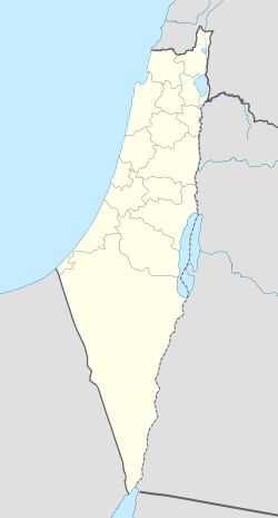
| Subdistrict | Haifa |
| Coordinates | 32°38′41″N 34°59′17″E / 32.64472°N 34.98806°ECoordinates: 32°38′41″N 34°59′17″E / 32.64472°N 34.98806°E |
| Palestine grid | 149/227 |
| Population | 2,970 (1945) |
| Date of depopulation | 24–26 July 1948[2] |
| Cause(s) of depopulation | Military assault by Yishuv forces |
| Current localities | Kerem Maharal[3] |
Ijzim (Arabic: إجزم) was a Palestinian village located in the Haifa Subdistrict of British Mandate Palestine, 19.5 kilometers south of the city, that was depopulated during the 1948 Arab-Israeli war. Many of its Arab inhabitants ended up as refugees in Jenin after a group of Israeli special forces composed of members of the Golani, Carmeli and Alexandroni Brigades attacked the village in Operation Shoter on 24 July 1948.[4]
Families from Ijzim include the Madis, the Nabhanis and the Alhassans with the majority of the families derived from the Bani Nabhan tribe. Collectively, they owned over 40,000 dunams (40 km²) of land and were considered one of the richest villages in Palestine.[5]
History
The French explorer Victor Guérin visited in 1870 and found "an ancient marble column at the door of a mosque; in the valley below the village a large square well, built with regular stones and surmounted by a vaulted construction. Near the well a birket, no longer used, and partly filled up, and close at hand the foundations of an ancient tower, measuring 15 paces by 10, and built with large masonry."[6] In 1873, SWP surveyed three ancient rock-cut tombs north of the village.[7]
Ottoman rule
In 1596, Ijzim was a village in the nahiya of Shafa (liwa' of Lajjun), with a population of fifty-five. It paid taxes on a number of crops, including wheat, barley, and olives as well as on other types of produce, such as goats and beehives.[8]
The village appeared, though misplaced, under the name of Egzim on the map that Pierre Jacotin compiled during Napoleon's invasion of 1799.[9]
Ijzim was the primary seat of the Banu Madi family and the largest locality in the region during part of the eighteenth and first half of the nineteenth century. The "area of origin" of the Madi family was the coastal region south of Carmel and the Western slopes of Jabal Nablus.[10] At the time, the Banu Madi were the most influential family in Southern Galilee and on the coast.[11] The heyday of the family appears to have been in the period between the end of Jazzar Pasha´s rule (1804) and the Egyptian occupation (1831). Mas'ud al-Madi was the governor of Gaza at the time of the Egyptian invasion. He lost his life because of his participation in the anti-Egyptian uprising in 1834,[12] while other clan members were put to prison and some were able to flee to Constantinople. After the return of the Ottomans, some family members were appointed as shaykhs or governors in Ijzim, Haifa, and Safad.[13] Yet by 1850's the al-Madi family of Ijzim no longer constituted a local power like some families of Nablus or Hebron.
In 1859 Ijzim was visited by the British Consul Rodgers, who estimated 1,000 inhabitants, who cultivated 64 feddans of land.[14]
British Mandate era
In the 1922 census of Palestine conducted by the British Mandate authorities, Ijzim had a population 1,610, one Christian and the rest Muslims.[15] In the 1931 census Ijzim was counted together with Khirbat Al-Manara, Al-Mazar and Qumbaza. The total population was 2,160, 88 Christians, 2,082 Muslims, in a total of 442 houses.[16]
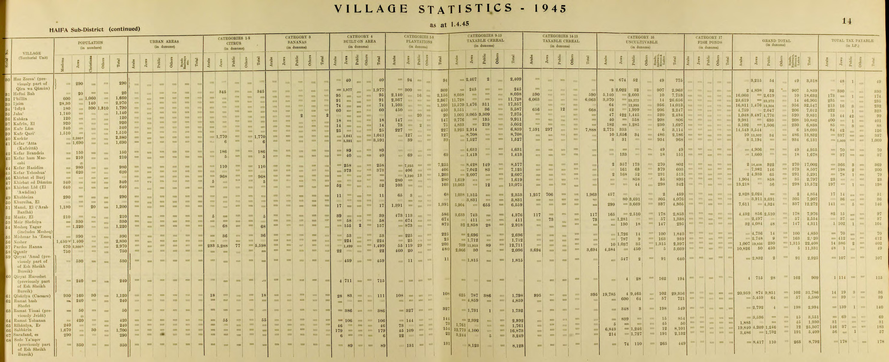
In 1945 the population of Ijzim was 2,970, all Arabs, and it had 45,905 dunams of land according to an official land and population survey.[17] 2,367 dunams were for plantations and irrigable land, 17,791 for cereals,[18] while 91 dunams were built-up (urban) land.[19]
1948 War and aftermath
Ijzim was one of the three villages in the Little Triangle that blocked the Jewish transportation in the main Tel Aviv-Haifa Highway for many months during the 1948 war.[5] Jewish forces had twice attempted to capture the village unsuccessfully. Their third attempt on the 24 July 1948 involved the use of cannon fire and air strikes in a fierce battle that lasted two days.[5] This took place during an official truce in the fighting, the attack was therefore called a "police action", and the Israeli authorities later lied to the UN, claiming that no military planes were involved.[20]
With the conquest of Ijzim, the majority of the villagers either were expelled or fled. The majority ended up in the Jenin area, on the other side of the armistice lines drawn in 1949.[5] Others took refuge in the nearby Druze village of Daliyat al-Carmel. There were several dozen people from Ijzim that were allowed to remain in their homes due to connections they enjoyed with influential Jews.[5] These individuals continued to work their fertile land, sending the agricultural produce to Haifa. They were registered in the first Israeli census and received Israeli identity cards.[5]
In December 1948, the Jewish protectors of the residents of Ijzim and the Haifa district military commander had a dispute over the villagers' continued presence there.[5] It was decided that the villagers that had remained in Ijzim could stay and those who had taken refuge in Daliyat al-Carmel would be permitted to return.[5] However, the district commander later went back on his word and ordered the eviction of the villagers, who then took shelter in the nearby village of Fureidis.[5]
Meron Benvenisti submits that one of the considerations leading to the eviction of the inhabitants of Ijzim was the interest of settlement agency officials in turning Ijzim into an immigrant moshav.[5] In the summer of 1949, just a few months after the villagers had been evicted, a moshav made up of immigrants from Czechoslovakia and Romania was established in Ijzim.[5]
Unlike many other depopulated Palestinian villages where new permanent Jewish settlements were built adjacent to the houses of the former Arab villages, which were then demolished, the homes of Ijzim were maintained for habitation by the new immigrants.[5] The al-Madi family's luxurious seventeenth-century madafeh was transformed into a museum and then the home of a Jewish family, the village school became a synagogue, and the village cemetery, a public park.[5] The large village mosque, constructed in the nineteenth century, was left to fall into dereliction.[5]
Some of the villagers of Ijzim attempted to hold on to their land, living for a few years in tin-roofed shacks and other temporary structures.[5] However, all of them — with the exception of one family — finally broke down and agreed to exchange their land holdings in Ijzim for building plots in the village of Fureidis.[5] The one Arab family that withstood the pressure to leave continues to live in its own house beside a sacred spring called Sitt Maqura, where today both Arabs and Jews come to pray and light candles.[5]
One of the former houses of Ijzim is occupied by Ami Ayalon, former head of Shin Bet, Israel's secret service.[21]
Andrew Petersen, an archaeologist specializing in Islamic architecture, surveyed the village in 1994, and described two larger structures; the mosque and the "castle".[22]
Demographics
| Year | Christians | Muslims | Jews | Total Population |
|---|---|---|---|---|
| 1596 | 0[23] | 10 households[23] | 0[23] | 55[8] |
| 1859 | - | - | 0 | 1,000[14] |
| 1922 | 1 | 1609 | 0 | 1,610[15] |
| 1945 | 140[24] | 2,830[24] | 0[24] | 2,970[17][24] |
| 1949: Reestablished Kerem Maharal as a Jewish Moshav | ||||
| 1950 | - | >100[5] | - | - |
| 1960 | 0 | >10[5] | - | - |
| 1970 | 0 | >10[5] | - | - |
| 1980 | 0 | 1[5] | - | - |
| 2006 | 0 | 0 | 566 | 566[25] |
| 2011 | 0 | 0 | 634 | 634 |
Notable people
- Adnan Awad, politician, revolutionary
- Mas'ud al-Madi, politician, revolutionary
- Mu'in al-Madi, politician
- Taqiuddin al-Nabhani, judge, Islamic scholar, politician
- Yusuf an-Nabhani, judge, poet, Islamic scholar
See also
References
- ↑ Palmer, 1881, p. 146
- ↑ Morris, 2004, p. XVIII, village #167. Morris also gives cause(s) of depopulation.
- ↑ Morris, 2004, p. XXII, settlement #119.
- ↑ "Welcome to Ijzim". Palestine Remembered.
- 1 2 3 4 5 6 7 8 9 10 11 12 13 14 15 16 17 18 19 20 21 Benvenisti, 2000, pp. 207 -208
- ↑ Guérin, 1875, p. 300, as translated by Conder and Kitchener, 1882, SWP II, p. 53
- ↑ Conder and Kitchener, 1882, SWP II, p. 53
- 1 2 Hütteroth and Abdulfattah, 1977, p. 158. As estimated in Khalidi, 1992, p. 164
- ↑ Karmon, 1960, p. 163
- ↑ Schölch, 1993, p. 182
- ↑ Rogers, 1855, p.31, and others, quoted in Schölch, 1993, p. 182.
- ↑ Rustum, Asad Jibrail: "New Light on the Peasants ´Revolt in Palestine April–September, 1834," JPOS 10 (1934), pp.11-15, quoted in Schölch, 1993, p.182
- ↑ Mauhammad al-Madi was governor of Haifa as late as 1855, Public Record Office, London, Foreign Office, Series 78 (1853-1883), vol 1120 (Sidon, 29 September 1855), quoted in Schölch, 1993, p.182
- 1 2 Conder and Kitchener, 1882, SWP II, p. 41. Quoted in Khalidi, 1992, p.164
- 1 2 Barron, 1923, Table XI, Sub-district of Haifa, p. 33
- ↑ Mills, 1932, p. 91
- 1 2 Government of Palestine, Department of Statistics. Village Statistics, April, 1945. Quoted in Hadawi, 1970, p. 48
- ↑ Government of Palestine, Department of Statistics. Village Statistics, April, 1945. Quoted in Hadawi, 1970, p. 90
- ↑ Government of Palestine, Department of Statistics. Village Statistics, April, 1945. Quoted in Hadawi, 1970, p. 140
- ↑ Morris, 2004, pp. 438-441
- ↑ Pappe, 2006, p. 164
- ↑ Petersen, 2001, pp. 152-154
- 1 2 3 Hütteroth and Abdulfattah, 1977, p. 158
- 1 2 3 4 Department of Statistics, 1945, p. 14
- ↑ "Kerem Maharal | Online references | cyclopaedia.net". www.cyclopaedia.info. Retrieved 2015-10-06.
Bibliography
- Barron, J. B., ed. (1923). Palestine: Report and General Abstracts of the Census of 1922. Government of Palestine.
- Benvenisti, Meron (2000). Sacred Landscape: The Buried History of the Holy Land Since 1948. University of California Press. ISBN 978-0-520-23422-2.
- Conder, Claude Reignier; Kitchener, H. H. (1882). The Survey of Western Palestine: Memoirs of the Topography, Orography, Hydrography, and Archaeology. 2. London: Committee of the Palestine Exploration Fund.
- Department of Statistics (1945). Village Statistics, April, 1945. Government of Palestine.
- Guérin, Victor (1875). Description Géographique Historique et Archéologique de la Palestine (in French). 2: Samarie, pt. 2. Paris: L'Imprimerie Nationale.
- Hadawi, Sami (1970). Village Statistics of 1945: A Classification of Land and Area ownership in Palestine. Palestine Liberation Organization Research Center.
- Hütteroth, Wolf-Dieter; Abdulfattah, Kamal (1977). Historical Geography of Palestine, Transjordan and Southern Syria in the Late 16th Century. Erlanger Geographische Arbeiten, Sonderband 5. Erlangen, Germany: Vorstand der Fränkischen Geographischen Gesellschaft. ISBN 3-920405-41-2.
- Karmon, Y. (1960). "An Analysis of Jacotin's Map of Palestine" (PDF). Israel Exploration Journal. 10 (3,4): 155–173; 244–253.
- Khalidi, Walid (1992). All That Remains: The Palestinian Villages Occupied and Depopulated by Israel in 1948. Washington D.C.: Institute for Palestine Studies. ISBN 0-88728-224-5.
- Mills, E., ed. (1932). Census of Palestine 1931. Population of Villages, Towns and Administrative Areas. Jerusalem: Government of Palestine.
- Morris, Benny (2004). The Birth of the Palestinian Refugee Problem Revisited. Cambridge University Press. ISBN 978-0-521-00967-6.
- Mülinen, Egbert Friedrich von 1908, Beiträge zur Kenntnis des Karmels "Separateabdruck aus der Zeitschrift des Deutschen Palëstina-Vereins Band XXX (1907) Seite 117-207 und Band XXXI (1908) Seite 1-258." Ikzim p.287 ff
- Palmer, E. H. (1881). The Survey of Western Palestine: Arabic and English Name Lists Collected During the Survey by Lieutenants Conder and Kitchener, R. E. Transliterated and Explained by E.H. Palmer. Committee of the Palestine Exploration Fund.
- Pappé, Ilan (2006). The Ethnic Cleansing of Palestine. London and New York: Oneworld. ISBN 1-85168-467-0.
- Petersen, Andrew (2001). A Gazetteer of Buildings in Muslim Palestine (British Academy Monographs in Archaeology). 1. Oxford University Press. ISBN 978-0-19-727011-0.
- Rogers, Edward Thomas (1855) Notices of the modern Samaritans: illustrated by incidents in the life of Jacob Esh Shelaby Published by S.Low, 55 pages
- Schölch, Alexander (1993). Palestine in Transformation, 1856-1882: Studies in Social, Economic, and Political Development. Institute for Palestine Studies. ISBN 0-88728-234-2.
- Sharon, Moshe (2013). Corpus Inscriptionum Arabicarum Palaestinae, H-I. 5. BRILL. ISBN 90-04-25097-2. (Sharon, 2013, p. 303)
External links
- Welcome To Ijzim
- Survey of Western Palestine, Map 8: IAA, Wikimedia commons
- Ijzim photos, from Dr. Moslih Kanaaneh
- Ijzim, from the Khalil Sakakini Cultural Center