2016 Te Araroa earthquake
 | |
| Date | 2 September 2016 |
|---|---|
| Origin time | 4:37:55 am NZST |
| Magnitude | 7.1 Mw |
| Depth | 22 km (14 mi) |
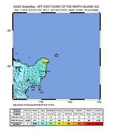
| Epicenter | 36°59′S 179°31′E / 36.98°S 179.52°ECoordinates: 36°59′S 179°31′E / 36.98°S 179.52°E[1] |
| Type | Oblique-slip[2] |
| Areas affected | New Zealand |
| Max. intensity | VI (Strong)[1] |
| Tsunami | 30 cm at East Cape and Great Barrier Island |
The 2016 Te Araroa earthquake was an earthquake measuring 7.1 on the moment magnitude scale that occurred at 04:37:55 NZST (16:37:55 UTC) on 2 September 2016.[3] The epicentre was located 125 km (78 mi) north-east of Te Araroa off the East Cape of the North Island of New Zealand with a focal depth of 22 km (14 mi). The earthquake was widely felt throughout the North Island and in the upper South Island. There were no reported casualties, and buildings predominantly suffered only superficial damage.
Earthquake
Foreshock
A magnitude 5.7 earthquake was recorded at 10:04:35 NZST on 1 September 2016, one day prior to the main earthquake.
| Date | Local time (NZST) |
Magnitude | Hypocenter depth |
Epicenter | ||
|---|---|---|---|---|---|---|
| Location | Latitude | Longitude | ||||
| 1 September 2016 | 10:04:35[4] | 5.7 | 26 km (16 mi) | 100 km north-east of Te Araroa | -37.06 | 179.21 |
Aftershocks
A series of aftershocks followed the earthquake, the largest being a magnitude 6.2 earthquake which occurred at 05:15:05 NZST on 2 September. Dozens of smaller aftershocks were also recorded, with 18 measuring magnitude 5.0 or greater as of 4 November 2016. GeoNet forecast the probability of one or more additional aftershocks measuring between 6.0 and 6.9 as 32% for the month to 12 October while the probability of an earthquake greater than or equal to 7.0 was 4% for the same period.[5]
| Date | Local time (NZST) |
Magnitude | Hypocenter depth |
Epicenter | ||
|---|---|---|---|---|---|---|
| Location | Latitude | Longitude | ||||
| 2 September 2016 | 04:37:55[6] | 7.1 | 22 km (14 mi) | 125 km north-east of Te Araroa | -36.98 | 179.52 |
| 2 September 2016 | 04:48:05[7] | 5.2 | 17 km (11 mi) | 85 km north-east of Te Araroa | -37.00 | 178.93 |
| 2 September 2016 | 05:01:09[8] | 5.7 | 19 km (12 mi) | 95 km north-east of Te Araroa | -37.00 | 179.14 |
| 2 September 2016 | 05:14:05[9] | 6.2 | 20 km (12 mi) | 110 km north-east of Te Araroa | -36.91 | 179.21 |
| 2 September 2016 | 05:34:27[10] | 5.1 | 26 km (16 mi) | 95 km north-east of Te Araroa | -37.13 | 179.23 |
| 2 September 2016 | 05:36:03[11] | 5.7 | 58 km (36 mi) | 90 km north-east of Te Araroa | -37.09 | 179.15 |
| 2 September 2016 | 07:18:28[12] | 5.8 | 18 km (11 mi) | 90 km north-east of Te Araroa | -37.05 | 179.10 |
| 2 September 2016 | 08:06:03[13] | 6.0 | 18 km (11 mi) | 125 km east of Te Araroa | -37.14 | 179.66 |
| 3 September 2016 | 16:30:10[14] | 5.5 | 12 km (7.5 mi) | 70 km east of Te Araroa | -37.36 | 179.11 |
| 3 September 2016 | 16:58:36[15] | 5.2 | 114 km (71 mi) | 70 km north-east of Te Araroa | -37.26 | 178.99 |
| 4 September 2016 | 01:30:26[16] | 5.5 | 18 km (11 mi) | 65 km east of Te Araroa | -37.39 | 179.02 |
| 4 September 2016 | 18:19:42[17] | 5.0 | 32 km (20 mi) | 95 km north-east of Te Araroa | -37.12 | 179.25 |
| 5 September 2016 | 08:00:28[18] | 5.1 | 17 km (11 mi) | 55 km east of Te Araroa | -37.41 | 178.96 |
| 6 September 2016 | 03:19:01[19] | 5.7 | 21 km (13 mi) | 95 km north-east of Te Araroa | -37.00 | 179.06 |
| 6 September 2016 | 05:01:58[20] | 5.3 | 19 km (12 mi) | 95 km north-east of Te Araroa | -37.00 | 179.08 |
| 15 September 2016 | 04:09:29[21] | 5.0 | 20 km (12 mi) | 80 km north-east of Te Araroa | -37.13 | 179.04 |
| 23 September 2016 | 17:56:27[22] | 5.1 | 22 km (14 mi) | 65 km east of Te Araroa | -37.42 | 179.06 |
| 9 October 2016 | 08:41:16[23] | 5.8 | 7 km (4.3 mi) | 75 km north-east of Te Araroa | -37.08 | 178.89 |
| 4 November 2016 | 07:45:47[24] | 5.0 | 95 km (59 mi) | 260 km north-east of Te Araroa | -35.98 | -179.58 |
Aftermath
Following the earthquake, the Ministry of Civil Defence & Emergency Management (MCDEM) issued a tsunami warning for parts of the north and east coasts of the North Island. Waves measuring 30 cm in height were recorded by tide gauges at East Cape and Great Barrier Island, and although the warning was later cancelled advisories remained in place for stong currents and abnormal sea level fluctuations.[25]
Power outages temporarily affected 300 homes near Rototahi and Waimata north of Gisborne while KiwiRail issued a precautionary shutdown notice for part of the rail network in Auckland.[25]
While no injuries or significant damage occurred, a spokesperson for the Earthquake Commission said they had received 48 claims for damage compensation by 4:30 pm local time on the day of the earthquake.[26] Damage was localised to coastal towns near the epicentre of the earthquake, including in Te Puia Springs where Puketiti Homestead and Stable, a Category 1 historic building, suffered damage to a chimney and fireplace.[27]
References
- 1 2 3 "M7.1 - 166km NE of Gisborne, New Zealand: ShakeMap". earthquake.usgs.gov. Retrieved 2016-09-03.
- ↑ "M7.1 - 166km NE of Gisborne, New Zealand". earthquake.usgs.gov. Retrieved 2016-09-04.
- ↑ "Magnitude 7.1, Fri, Sep 2 2016, 4:37:55 am (NZST)". geonet.org.nz. Retrieved 2016-10-04.
- ↑ "Magnitude 5.7, Thu, Sep 1 2016, 10:04:35 am (NZST)". www.geonet.org.nz. Retrieved 2016-09-03.
- ↑ "M7.1 East Cape Earthquake: what we think will happen next". info.geonet.org.nz. Retrieved 2016-09-09.
- ↑ "Magnitude 7.1, Fri, Sep 2 2016, 4:37:55 am (NZST)". www.geonet.org.nz. Retrieved 2016-09-03.
- ↑ "Magnitude 5.2, Fri, Sep 2 2016, 4:48:05 am (NZST)". www.geonet.org.nz. Retrieved 2016-09-03.
- ↑ "Magnitude 5.7, Fri, Sep 2 2016, 5:01:09 am (NZST)". www.geonet.org.nz. Retrieved 2016-09-03.
- ↑ "Magnitude 6.2, Fri, Sep 2 2016, 5:14:05 am (NZST)". www.geonet.org.nz. Retrieved 2016-09-03.
- ↑ "Magnitude 5.1, Fri, Sep 2 2016, 5:34:27 am (NZST)". www.geonet.org.nz. Retrieved 2016-09-03.
- ↑ "Magnitude 5.7, Fri, Sep 2 2016, 5:36:03 am (NZST)". www.geonet.org.nz. Retrieved 2016-09-03.
- ↑ "Magnitude 5.8, Fri, Sep 2 2016, 7:18:28 am (NZST)". www.geonet.org.nz. Retrieved 2016-09-03.
- ↑ "Magnitude 6.0, Fri, Sep 2 2016, 8:06:03 am (NZST)". www.geonet.org.nz. Retrieved 2016-09-03.
- ↑ "Magnitude 5.5, Sat, Sep 3 2016, 4:30:10 pm (NZST)". www.geonet.org.nz. Retrieved 2016-09-03.
- ↑ "Magnitude 5.2, Sat, Sep 3 2016, 4:58:36 pm (NZST)". www.geonet.org.nz. Retrieved 2016-09-03.
- ↑ "Magnitude 5.5, Sun, Sep 4 2016, 1:30:26 am (NZST)". www.geonet.org.nz. Retrieved 2016-09-03.
- ↑ "Magnitude 5.0, Sun, Sep 4 2016, 6:19:42 pm (NZST)". www.geonet.org.nz. Retrieved 2016-09-04.
- ↑ "Magnitude 5.1, Mon, Sep 5 2016, 8:00:28 am (NZST)". www.geonet.org.nz. Retrieved 2016-09-05.
- ↑ "Magnitude 5.7, Tue, Sep 6 2016, 3:19:01 am (NZST)". www.geonet.org.nz. Retrieved 2016-09-05.
- ↑ "Magnitude 5.3, Tue, Sep 6 2016, 5:01:58 am (NZST)". www.geonet.org.nz. Retrieved 2016-09-05.
- ↑ "Magnitude 5.0, Thu, Sep 15 2016, 4:09:29 am (NZST)". www.geonet.org.nz. Retrieved 2016-09-14.
- ↑ "Magnitude 5.1, Fri, Sep 23 2016, 5:56:27 pm (NZST)". www.geonet.org.nz. Retrieved 2016-09-23.
- ↑ "Magnitude 5.8, Sun, Oct 9 2016, 8:41:16 am (NZDT)". www.geonet.org.nz. Retrieved 2016-10-08.
- ↑ "Magnitude 5.0, Fri, Nov 4 2016, 7:45:47 am (NZDT)". www.geonet.org.nz. Retrieved 2016-11-04.
- 1 2 "East Cape shake increases risk of big quakes, tsunami threats". RNZ. 2016-09-01. Retrieved 2016-09-04.
- ↑ "Aftershocks continue to rattle East Cape". RNZ. 2016-09-02. Retrieved 2016-09-04.
- ↑ "Quake damages historic homestead". Stuff. Retrieved 2016-09-04.