2013 Balochistan earthquakes
 Quetta Awaran Karachi | |
| Date | 24 September 2013 |
|---|---|
| Origin time | 11:29:48 UTC (16:29:48 PKT) |
| Magnitude | 7.7 Mw |
| Depth | 15.0 km (9.3 mi) |
| Epicenter | 26°58′N 65°31′E / 26.97°N 65.52°ECoordinates: 26°58′N 65°31′E / 26.97°N 65.52°E |
| Type | Oblique-slip |
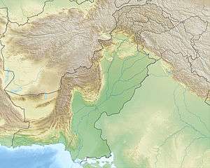
| Areas affected | Pakistan |
| Max. intensity | VII (Very strong) at Awaran |
| Casualties |
825 dead [1][2] 700 injured [3][4][5] |
The 2013 Balochistan earthquakes took place in late September in southwestern Pakistan. The mainshock had a moment magnitude of 7.7 and a maximum Mercalli intensity of VII (Very strong). At least 825 people were killed and hundreds more were injured. On 28 September, a M6.8 aftershock occurred to the north at a depth of 14.8 kilometres (9.2 miles), killing at least 22 people.[6][7]
Tectonic setting
On a broad scale, the tectonics of southern and central Pakistan reflect a complex plate boundary where the India plate slides northward relative to the Eurasia plate in the east, and the Arabia plate subducts northward beneath the Eurasia plate in the Makran (western Pakistan). These motions typically result in north-south to northeast-southwest strike-slip motion at the latitude of the 24 September earthquake that is primarily accommodated on the Chaman Fault, with the earthquake potentially occurring on one of the southern-most strands of this fault system. Further, more in-depth studies will be required to identify the precise fault associated with this event. Although seismically active, this portion of the Eurasia plate boundary region has not experienced large damaging earthquakes in recent history. In the past 40 years, only one significant event has occurred within 200 kilometres (120 mi) of this event, which was a Mw 6.1 earthquake in July 1990 that killed six people.[8]
Earthquake
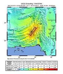
The United States Geological Survey reported that the earthquake took place on Tuesday 24 September 2013 at 11:29:48 UTC. The depth was reported to be 15 kilometres (9.3 mi). The earthquake reportedly lasted about a minute, causing panic in cities of southern Pakistan such as Karachi and Hyderabad.[9]
The earthquake in occurred as the result of oblique-strike-slip type motion at shallow crustal depths. The location and mechanism of the earthquake are consistent with rupture within the Eurasia plate above the Makran Trench subduction zone. The event occurred within the transition zone between northward subduction of the Arabian plate beneath the Eurasia plate and northward collision of the India plate with the Eurasia plate.[8]
Damage
The earthquake killed at least 825 people and injured hundreds of others.[2] The earthquake struck a sparsely populated region of Pakistan. Most homes and buildings in the region are constructed of mud bricks and collapsed during the earthquake and aftershocks. An official in the Balochistan province claimed that 80 percent of the homes in the Awaran district had collapsed or were damaged.[10] In the regional capital Quetta, some areas appeared to be badly damaged.[11][12] Officials from the Balochistan government estimated that at least 21,000 houses had been completely destroyed by the tremor, while some areas remained beyond the reach of rescue services 48 hours after the initial quake.[3]
PAGER impact estimates from the United States Geological Survey included a red alert level for initial shaking-related fatalities (35% chance of 1,000–10,000 fatalities, 27% chance of 10,000–100,000 fatalities) and an orange alert level for economic impact (35% chance of US$100 million–$1 billion, 26% chance of US$1–10 billion).[13]
The earthquake was felt in major cities across Pakistan, including Karachi, Hyderabad, Rawalpindi/Islamabad, Larkana, and Lahore.[9] The quake was also felt in Delhi, India, where some buildings shook,[14] and Muscat, Oman—800 kilometres (500 mi) from the epicenter—where mild tremors shook tables and cabinets.[15] The earthquake shook in the parts of UAE, Iraq, Afghanistan, Iran and as far as Qatar.[16] The earthquake also shook Saravan, Iran without causing any damage or casualties.[17] There were also minor tremors and aftershocks in the United Arab Emirates.[18]
Ground effects

The earthquake was apparently powerful enough to raise a small island, later dubbed Zalzala Jazeera, meaning "quake island", in the Arabian Sea, variously reported as being 350 metres (1,150 ft) to 1 kilometre (0.62 mi) off the shore of Gwadar.[12][19][20] The island is partially composed of rocks, but mostly consists of mud and sand. The oval-shaped island is 60 feet (18 m) high, 100 feet (30 m) long, and 250 feet (76 m) wide according to a Pakistani Navy team which visited the island the day after it appeared.[21]
The island is believed to be the result of a mud volcano.[22] In the region, deposits of frozen gas hydrates—which have a large methane content—exist beneath 300 to 800 metres (980–2,620 ft) of compressed sediment.[23] After such a large earthquake, the gas hydrates converted from frozen to gaseous form through the heat of friction and either raised the overlaying sediment enough to create fissures through which it escaped or rose through fissures resulting from the earthquake itself. Another possible contributing factor in the island's creation was the liquefaction of the seabed, which allowed finer, loosely packed sediments to become liquid-like and squeeze up through fissures in overlying compressed sediment. Locals who ventured to the island shortly after it formed heard a hissing noise at one end and started a fire which was difficult to extinguish. There are several mud volcanoes inland near Zalzala Jazeera and they are common in the vicinity of subducting plate boundaries; in fact, similar islands have appeared in the same region following earthquakes in 1945, 1999, 2001, and 2010. Because of its composition of softer sediments, the sea will erode the island completely within a few months.[21][23]
Aftershocks
- Mw 5.9 earthquake at 27°17′42″N 65°39′47″E / 27.295°N 65.663°E occurred at 11:36:31 UTC (16:36:31 PKT) on 24 September at a depth of 24.5 km (15.2 mi).[24]
- Mw 5.0 earthquake at 27°18′36″N 65°35′38″E / 27.310°N 65.594°E occurred at 12:42:12 UTC (17:42:12 PKT) on 24 September at a depth of 25.7 km (16.0 mi).[25] According to Pakistan's National Seismic Monitoring Centre, this aftershock occurred at 17:42:16 PKT (12:42:16 UTC) at 27°18′N 65°48′E / 27.30°N 65.80°E with a magnitude of 5.2 and a focal depth of 26 km.[26]
- Mw 5.6 earthquake at 27°20′35″N 65°38′31″E / 27.343°N 65.642°E occurred at 13:01:40 UTC (18:01:40 PKT) on 24 September at a depth of 27.7 km (17.2 mi).[27]
- Mw 5.2 earthquake at 27°34′05″N 65°42′25″E / 27.568°N 65.707°E occurred at 14:08:34 UTC (19:08:34 PKT) on 24 September at a depth of 27.1 km (16.8 mi).[28]
- Mw 5.5 earthquake at 27°11′35″N 65°29′13″E / 27.193°N 65.487°E occurred at 20:20:15 UTC (01:20:15 PKT) on 24 September at a depth of 23.6 km (14.7 mi).[29]
- Mw 6.8 earthquake at 27°15′47″N 65°35′13″E / 27.263°N 65.587°E occurred at 07:34:07 UTC (12:34:07 PKT) on 28 September at a depth of 14.8 km (9.2 mi).[30]
Aftermath
On 26 September, two days after the disaster, two rockets were fired at a helicopter carrying Maj. Gen. Muhammad Saeed Aleem, the National Disaster Management Authority chairman, as well as other officials and members of the media. Government sources blamed Balochi separatists, who are very active in the Awaran area.[3]
See also
References
- ↑ "825 dead, relief slow to reach Balochistan quake victims". Dunya News. 4 October 2013.
- 1 2 "Balochistan quake: toll jumps to 825". The Nation (Pakistan). 1 October 2013. Retrieved 4 October 2013.
- 1 2 3 "Pakistan quake death toll rises to 350". CNN. 26 September 2013. Retrieved 26 September 2013.
- ↑ "Pakistan: Death toll in the earthquake rises to 515". The Indian Express. 27 September 2013.
- ↑ "More than 100,000 left homeless after Pakistan earthquake". Al Jazeera. 27 September 2013.
- ↑ "M6.8 - 96 kilometres NNE of Awaran, Pakistan". United States Geological Survey. 28 September 2013.
- ↑ Agence France Presse (28 September 2013). "Powerful new Pakistan earthquake kills at least 22". Yahoo! News. Retrieved 1 October 2013.
- 1 2
 This article incorporates public domain material from the United States Geological Survey document: "M7.7 - 63km NNE of Awaran, Pakistan".
 - 1 2 Menon, Meena (24 September 2013). "Quake in southern Pakistan kills 2, damages houses". Chennai, India: The Hindu. Retrieved 24 September 2013.
- ↑ "At least 208 killed in Balochistan earthquake". Dawn. 25 September 2013. Retrieved 25 September 2013.
- ↑ Yusufzai, Gul (24 September 2013). "Quake kills 45 in Pakistan, creates new island in sea". Reuters. Retrieved 24 September 2013.
- 1 2 "Deadly earthquake strikes Pakistan's Balochistan". BBC News. 25 September 2013. Retrieved 24 September 2013.
- ↑ "M7.8 – 69km NNE of Awaran, Pakistan (BETA)". Earthquake Hazards Program. United States Geological Survey. Retrieved 24 September 2013.
- ↑ "Powerful earthquake strikes Pakistan's Balochistan". BBC News. 25 September 2013. Retrieved 24 September 2013.
- ↑ Vaidya, Sunil. "Tremors from Pakistan quake felt in Muscat". gulfnews.com. Retrieved 24 September 2013.
- ↑ "New photos of Pakistan's 'Earthquake Island'". Fox News. Retrieved 24 September 2013.
- ↑ "Strong Quake in Pakistan Spares Southeast Iran". Tasnim News Agency. 2013-09-25. Retrieved 27 September 2013.
- ↑ "Earthquake jolts Pakistan, tremors felt in". Gulf News. 28 September 2013.
- ↑ "Pakistan quake island off Gwadar 'emits flammable gas'". BBC News. 25 September 2013.
- ↑ "Island discovered as a result of earthquake in Pakistan". IBNLive.in.com. Press Trust of India. Retrieved 24 September 2013.
- 1 2 Zolfagharifard, Ellie (25 September 2013). "The world's freshest real estate: Massive Pakistani earthquake heaves a brand new 18 meter high island above the waves". London: The Daily Mail. Retrieved 26 September 2013.
- ↑ "Satellites reveal new views of Pakistan's 'Earthquake Island'". NBC News. 1 October 2013. Retrieved 9 October 2013.
- 1 2 Khan, Ilyas (27 September 2013). "Pakistan quake island off Gwadar 'emits flammable gas'". BBC News. Retrieved 26 September 2013.
- ↑ "M5.9 – 102km NNE of Awaran, Pakistan". United States Geological Survey. Retrieved 24 September 2013.
- ↑ "M5.0 – 101km NNE of Awaran, Pakistan". United States Geological Survey. Retrieved 24 September 2013.
- ↑ "Latest Earthquakes". Pakistan Meteorological Department—National Seismic Monitoring Centre, KARACHI. Retrieved 24 September 2013.
- ↑ "M5.6 – 100km WSW of Khuzdar, Pakistan". United States Geological Survey. Retrieved 24 September 2013.
- ↑ "M5.2 – 94km WSW of Khuzdar, Pakistan". United States Geological Survey. Retrieved 24 September 2013.
- ↑ "M5.5 – 85km NNE of Awaran, Pakistan". United States Geological Survey. Retrieved 24 September 2013.
- ↑ "M6.8 - 96km NNE of Awaran, Pakistan". United States Geological Survey. Retrieved 28 September 2013.
Sources
- Avouac, J-P; Ayoub, F.; Wei, S.; Ampuero, J-P.; Meng, L.; Leprince, S.; Jolivet, R.; Duputel, Z.; Helmberger, D. (2014), "The 2013, Mw 7.7 Balochistan earthquake, energetic strike-slip reactivation of a thrust fault" (PDF), Earth and Planetary Science Letters, Elsevier, 391: 128–134, doi:10.1016/j.epsl.2014.01.036
- Jolivet, R.; Duputel, Z.; Riel, B.; Simons, M.; Rivera, L.; Minson, S. E.; Zhang, H.; Aivazis, M. A. G.; Ayoub, F.; Leprince, S.; Samsonov, S.; Motagh, M.; Fielding, E. J. (2014), "The 2013 Mw 7.7 Balochistan earthquake : Seismic potential of an accretionary wedge" (PDF), Bulletin of the Seismological Society of America, Seismological Society of America, 104 (2): 1020–1030, doi:10.1785/0120130313
External links
- M7.7 - 61km NNE of Awaran, Pakistan – United States Geological Survey.
- Pakistan quake island off Gwadar 'emits flammable gas' – BBC News
- The world's freshest real estate: Massive Pakistani earthquake heaves a brand new 18 meter high island above the waves – Daily Mail