South Range, Wisconsin
| South Range, Wisconsin | |
|---|---|
| Unincorporated community | |
 South Range  South Range Location of the community of South Range | |
| Coordinates: 46°36′29″N 91°59′01″W / 46.60806°N 91.98361°W | |
| Country | United States |
| State | Wisconsin |
| County | Douglas |
| Town | Parkland |
| Elevation | 761 ft (232 m) |
| Time zone | Central (CST) (UTC-6) |
| • Summer (DST) | CDT (UTC-5) |
| Area code(s) | 715 and 534 |
| GNIS feature ID | 1574481[1] |
South Range is an unincorporated community, located in the town of Parkland, Douglas County, Wisconsin, United States.
South Range is located 11 miles southeast of the city of Superior, in the northwestern part of the U.S. state of Wisconsin.
The center of South Range is generally considered at the junction of County Road C and County Road K.
Wisconsin Highway 35 and U.S. Highways 2 / 53 (co-signed) are the main routes in the area.[2]
Amnicon Falls State Park is located east of South Range.
Pattison State Park, and the Pattison Park Golf Course, are located west of South Range.
South Range has a post office with zip code 54874.
Four Corners Elementary School is in the area. Also, Lake Superior Elementary School serves most of the area. South Range is within the School District of Superior area. Maple School District is adjacent to South Range.
References
- ↑ U.S. Geological Survey Geographic Names Information System: South Range, Wisconsin
- ↑ Rand McNally. The Road Atlas '07. Chicago: Rand McNally, 2007, Wisconsin entry.
Coordinates: 46°36′29″N 91°59′01″W / 46.60806°N 91.98361°W
Municipalities and communities of Douglas County, Wisconsin, United States | ||
|---|---|---|
| City | 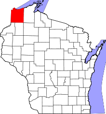 | |
| Villages | ||
| Towns | ||
| CDPs | ||
| Unincorporated communities |
| |
| Indian reservation | ||
| Footnotes | ‡This populated place also has portions in an adjacent county or counties | |