Saint-Christophe, Aosta Valley
| Saint-Christophe | ||
|---|---|---|
| Comune | ||
| Comune di Saint-Christophe Commune de Saint-Christophe | ||
 | ||
| ||
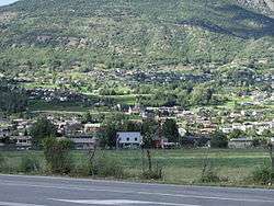
 Saint-Christophe Location of Saint-Christophe in Italy | ||
| Coordinates: 45°45′N 7°21′E / 45.750°N 7.350°E | ||
| Country | Italy | |
| Region | Aosta Valley | |
| Province / Metropolitan city | none | |
| Frazioni | Angelin, Bagnère, Chabloz, Champapon, Champ-d'Hône, Château d'Entrèves, Chef-Lieu, Clappey, Cognon, Cort, Coutateppaz, La Crétaz, La Croix-Noire, Fontanalle, Gérardin, Gevé, Grand-Chemin, Grande-Charrière, Léméryaz, Loups, Maillod, Méladière, Meysettaz, Nicolin, Olleyes, Ollignan, Pallein, Pin, Prévot, Rouye, Sorreley, Thuvex | |
| Government | ||
| • Mayor | Paolo Cheney | |
| Area | ||
| • Total | 14 km2 (5 sq mi) | |
| Elevation | 619 m (2,031 ft) | |
| Population (31 December 2010)[1] | ||
| • Total | 3,285 | |
| • Density | 230/km2 (610/sq mi) | |
| Demonym(s) | Saint-christopherins, Crétoublains | |
| Time zone | CET (UTC+1) | |
| • Summer (DST) | CEST (UTC+2) | |
| Postal code | 11020 | |
| Dialing code | 0165 | |
| Website | Official website | |

Saint-Christophe (French for Saint Christopher) is a town and comune in the Aosta Valley. It is located east of Aosta, on the left shore of the Dora Baltea.
Places of interest
The Passerin d'Entrèves castle is located in this commune.
The Bridge of Grand Arvou is in the Aosta commune nearby.
Transport
Aosta Airport is located in Saint-Christophe. Air Vallée had its head office on the grounds of Aosta Airport.[2]
Twinnings
See also
References
- ↑ Population data from Istat
- ↑ "World Airline Directory." Flight International. 20–26 March 2001. 72.
External links
![]() Media related to Saint-Christophe at Wikimedia Commons
Media related to Saint-Christophe at Wikimedia Commons
- Saint-Christophe (Italian)
- Mapquest - Saint-Christophe
This article is issued from Wikipedia - version of the 9/22/2016. The text is available under the Creative Commons Attribution/Share Alike but additional terms may apply for the media files.