Piandimeleto
| Piandimeleto | ||
|---|---|---|
| Comune | ||
| Comune di Piandimeleto | ||
 | ||
| ||
 Piandimeleto Location of Piandimeleto in Italy | ||
| Coordinates: 43°44′N 12°25′E / 43.733°N 12.417°ECoordinates: 43°44′N 12°25′E / 43.733°N 12.417°E | ||
| Country | Italy | |
| Region | Marche | |
| Province / Metropolitan city | Pesaro e Urbino (PU) | |
| Government | ||
| • Mayor | Stefano Benedetti | |
| Area | ||
| • Total | 40.0 km2 (15.4 sq mi) | |
| Elevation | 319 m (1,047 ft) | |
| Population (31 December 2010[1]) | ||
| • Total | 2,150 | |
| • Density | 54/km2 (140/sq mi) | |
| Demonym(s) | Pianmeletesi | |
| Time zone | CET (UTC+1) | |
| • Summer (DST) | CEST (UTC+2) | |
| Postal code | 61026 | |
| Dialing code | 0722 | |
| Patron saint | St. Blaise | |
| Saint day | 3 February | |

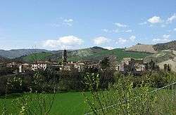
Piandimeleto is a comune (municipality) in the Province of Pesaro e Urbino in the Italian region Marche, located about 90 kilometres (56 mi) west of Ancona and about 45 kilometres (28 mi) southwest of Pesaro.
_-_BEIC_6354177.jpg)
1981 photo by Paolo Monti
Piandimeleto borders the following municipalities: Belforte all'Isauro, Carpegna, Frontino, Lunano, Macerata Feltria, Pietrarubbia, Sant'Angelo in Vado, Sassocorvaro, Sestino, Urbino. Its territory is included in the Sasso Simone and Simoncello Regional Park. The Foglia river flows near the town.
References
External links
This article is issued from Wikipedia - version of the 10/25/2016. The text is available under the Creative Commons Attribution/Share Alike but additional terms may apply for the media files.