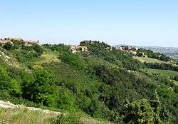
Colbordolo
| Colbordolo | ||
|---|---|---|
| Comune | ||
| former Comune di Colbordolo | ||
 | ||
| ||
 Colbordolo Location of Colbordolo in Italy | ||
| Coordinates: 43°49′N 12°43′E / 43.817°N 12.717°E | ||
| Country | Italy | |
| Region | Marche | |
| Province / Metropolitan city | Pesaro e Urbino (PU) | |
| Frazioni | Bottega, Cappone, Montefabbri, Pontevecchio, Talacchio, Morciola | |
| Government | ||
| • Mayor | / | |
| Area | ||
| • Total | 27.4 km2 (10.6 sq mi) | |
| Elevation | 293 m (961 ft) | |
| Population (28 February 2009)[1] | ||
| • Total | 6,217 | |
| • Density | 230/km2 (590/sq mi) | |
| Demonym(s) | Colbordolesi | |
| Time zone | CET (UTC+1) | |
| • Summer (DST) | CEST (UTC+2) | |
| Postal code | 61022 | |
| Dialing code | 0721 | |
| Patron saint | St. John the Baptist | |
| Saint day | 24 June | |
| united to Sant'Angelo in Lizzola 1 january 2014 | ||
Colbordolo was a comune (municipality) in the Province of Pesaro e Urbino in the Italian region Marche, disbanded in 2014[2] and united to Sant'Angelo in Lizzola, after 76.3 percent of the population approved in a referendum the unification.
The resulting municipality was called Comune di Vallefoglia, with the town hall in Sant'Angelo in Lizzola.
References
This article is issued from Wikipedia - version of the 5/18/2015. The text is available under the Creative Commons Attribution/Share Alike but additional terms may apply for the media files.