Chula Vista, Texas
| Chula Vista, Texas | |
|---|---|
| Census-Designated Place | |
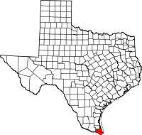
 Chula Vista, Texas Location within Texas | |
| Coordinates: 26°04′26″N 97°26′23″W / 26.07389°N 97.43972°WCoordinates: 26°04′26″N 97°26′23″W / 26.07389°N 97.43972°W | |
| Country | United States |
| State | Texas |
| County | Cameron |
| Elevation | 16 ft (5 m) |
| Time zone | Central (CST) (UTC-6) |
| • Summer (DST) | CDT (UTC-5) |
| ZIP codes | 78834 |
| Area code | 956 |
| GNIS feature ID | 2584621 |
Chula Vista is a census-designated place (CDP) in Cameron County, in the U.S. state of Texas. Prior to the 2010 census the community was part of the Chula Vista-Orason CDP. It is part of the Brownsville–Harlingen Metropolitan Statistical Area.
Geography
Chula Vista is near the geographic center of Cameron County, 2 miles (3 km) east of Los Fresnos and 15 miles (24 km) north of the center of Brownsville. It is bordered on the west by Orason.
References
This article is issued from Wikipedia - version of the 4/17/2016. The text is available under the Creative Commons Attribution/Share Alike but additional terms may apply for the media files.