Andover Forest, Lexington
| Andover Forest | |
|---|---|
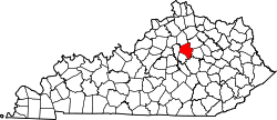
| Neighborhood of Lexington, Kentucky | |
| Country | United States |
| State | Kentucky |
| County | Fayette |
| City | Lexington |
| Area | |
| • Total | 0.456 sq mi (1.18 km2) |
| • Water | 0.0 sq mi (0.0 km2) |
| Population (2000) | |
| • Total | 1,128 |
| • Density | 2,475/sq mi (956/km2) |
| Time zone | Eastern (EST) (UTC-5) |
| • Summer (DST) | EDT (UTC-4) |
| ZIP code | 40509 |
| Area code(s) | 859 |
Andover Forest is a neighborhood in southeastern Lexington, Kentucky, United States. Its boundaries are Man o' War Boulevard to the north, former railroad tracks (now the Brighton East Bike Path) to the north, Pleasant Ridge Drive to the east, and McFarland Lane to the south.[1]
- Neighborhood statistics
- Area: 0.456 square miles (1.18 km2)
- Population: 1,128
- Population density: 2,475 people per square mile
- Median household income: $99,526[1]
References
- 1 2 Andover Forest Neighborhood Profile Retrieved 2013-01-26.


This article is issued from Wikipedia - version of the 4/6/2016. The text is available under the Creative Commons Attribution/Share Alike but additional terms may apply for the media files.