Žilina
| Žilina | |||
| City | |||
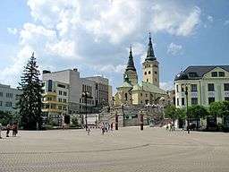 Andrej Hlinka Square | |||
|
|||
| Country | Slovakia | ||
|---|---|---|---|
| Region | Žilina | ||
| District | Žilina | ||
| Tourism region | Horné Považie | ||
| Rivers | Váh, Rajčanka, Kysuca | ||
| Center | Andrej Hlinka Square | ||
| - elevation | 342 m (1,122 ft) | ||
| - coordinates | SK 49°13′22″N 18°44′24″E / 49.22278°N 18.74000°ECoordinates: SK 49°13′22″N 18°44′24″E / 49.22278°N 18.74000°E | ||
| Area | 80.028 km2 (30.90 sq mi) | ||
| Population | 81,155 (2014-12-31) | ||
| - urban | 108,114 | ||
| - metro | 154,000 | ||
| Density | 1,014/km2 (2,626/sq mi) | ||
| First mentioned | 1208 | ||
| Mayor | Igor Choma | ||
| Timezone | CET (UTC+1) | ||
| - summer (DST) | CEST (UTC+2) | ||
| Postal code | 010 01 | ||
| Area code | +421-41 | ||
| Car plate | ZA | ||
  Location in Slovakia | |||
  Location in the Žilina Region | |||
| Wikimedia Commons: Žilina | |||
| Statistics: MOŠ/MIS | |||
| Website: www.zilina.sk | |||


Žilina (Slovak pronunciation: [ˈʒilina]; German: Sillein, [ziˈlaɪ̯n] or [ˈzɪlaɪ̯n]; Hungarian: Zsolna; Polish: Żylina, names in other languages) is a city in north-western Slovakia, around 200 kilometres (120 mi) from the capital Bratislava, close to both the Czech and Polish borders. It is the fourth largest city of Slovakia with a population of approximately 85,000, an important industrial center, the largest city on the Váh river, and the seat of a kraj (Žilina Region) and of an okres (Žilina District). It belongs to Upper Váh region of tourism.
Etymology
The name is derived from Slavic/Slovak word žila - a (river) vein.[1][2] Žilina means "a place with many watercourses". Alternatively, it is a secondary name derived from Žilinka river or from the name of local people Žilín/Žiliňane.[1]
History
The area around today's Žilina was inhabited in the late Stone Age (about 20,000 BC). In the 5th century Slavs started to move into the area. However, the first written reference to Žilina was in 1208 as terra de Selinan. From the second half of the 10th century until 1918, it was part of the Kingdom of Hungary.
In the middle of the 13th century terra Sylna was the property of the Cseszneky de Milvány family.[3] The city started to develop around year 1300, and according to records in 1312 it was already a town. In 1321, King Károly I made Žilina a free royal town. On 7 May 1381 King Lajos I issued Privilegium pro Slavis which made the Slav inhabitants equal to the Germans by allocating half of the seats at the city council to Slavs.[4] The town was burned in 1431 by the Hussites.
During the 17th century, Žilina gained position as a center of manufacturing, trade and education and during the baroque age many monasteries and churches were built as well as the Budatín Castle. In the Revolutions of 1848, Slovak volunteers, part of the Imperial Army, won a battle near the city against Hungarian honveds and gardists.
The city boomed in the second half of the 19th century as new railway tracks were built: the Kassa Oderberg Railway was finished in 1872 and the railway to Bratislava (Pozsony in Hungarian) in 1883, and new factories started to spring up, such as the drapery factory Slovena (1891) and the Považie chemical works (1892).
It was one of the first municipalities to sign the Martin Declaration (30 October 1918), and until March 1919 it was the seat of the Slovak government. On 6 October 1938, shortly after the Munich Agreement, the autonomy of Slovakia within Czechoslovakia was declared in Žilina.
During World War II, Žilina was captured on 30 April 1945 by Czechoslovak and Soviet troops of the 4th Ukrainian Front, after which it again became part of Czechoslovakia.
After Second World War, the city continued its development with many new factories, schools and housing projects being built. It was the seat of the Žilina Region from 1949–1960 and again since 1996.
Today Žilina is the third largest city in Slovakia, the third most important industrial center and the seat of a university, the Žilinská univerzita (founded in 1953). Since 1990 the historical center of the city has been largely restored and the city has built trolleybus lines.
Geography
Žilina lies at an altitude of 342 metres (1,122 ft) above sea level and covers an area of 80.03 square kilometres (30.9 sq mi).[5] It is located in the Upper Váh region (Slovak: Horné Považie) at the confluence of three rivers: Váh, flowing from east into south-west, Kysuca, flowing from north and Rajčanka rivers from south, in the Žilina Basin. The city is surrounded by these mountain ranges: Malá Fatra, Súľovské vrchy, Javorníky and Kysucká vrchovina. Protected areas nearby include the Strážov Mountains Protected Landscape Area, the Kysuce Protected Landscape Area, and the Malá Fatra National Park. There are two hydroelectric dams on the Váh river around Žilina: the Žilina dam in the East and the Hričov dam in the West.
Climate
Žilina lies in the north temperate zone and has a continental climate with four distinct seasons. It is characterized by a significant variation between hot summers and cold, snowy winters. The average temperature in July is 18 °C (64 °F), in January, −4 °C (25 °F). The average annual rainfall is 600–700 mm (23.6–27.6 in), most of the rainfall is in June and in the first half of July. Snow cover lasts from 60 to 80 days per year.
| Climate data for Žilina | |||||||||||||
|---|---|---|---|---|---|---|---|---|---|---|---|---|---|
| Month | Jan | Feb | Mar | Apr | May | Jun | Jul | Aug | Sep | Oct | Nov | Dec | Year |
| Average high °C (°F) | 0 (33) |
3 (38) |
8 (47) |
14 (58) |
20 (68) |
22 (72) |
25 (76) |
25 (77) |
20 (67) |
14 (58) |
6 (44) |
1 (35) |
13.2 (56.1) |
| Average low °C (°F) | −5 (22) |
−5 (23) |
−1 (30) |
3 (37) |
8 (46) |
10 (51) |
12 (54) |
12 (53) |
9 (47) |
5 (41) |
0 (33) |
−4 (26) |
3.7 (38.6) |
| Average precipitation cm (inches) | 2.85 (1.12) |
2.67 (1.05) |
3.10 (1.22) |
4.08 (1.61) |
4.82 (1.90) |
6.99 (2.75) |
6.84 (2.69) |
5.19 (2.04) |
4.74 (1.87) |
4.19 (1.65) |
3.91 (1.54) |
3.42 (1.35) |
52.8 (20.79) |
| Source: MSN Weather[6] | |||||||||||||
Symbol
The coat-of-arms of Žilina is a golden double-cross (so-called cross of Lorraine) with roots and two golden stars on an olive-green background. The double-cross is of Byzantine origin and stems from Cyrillic-methodic tradition. The coat-of-arms is one of the oldest municipal coat-of-arms not only in Slovakia but in Europe. It has been used as the city's symbol since 1378.
Demographics
| Municipality | Urban | Metro |
|---|---|---|
| Žilina | 85,302 | 85,302 |
| Kysucké Nové Mesto | - | 16,420 |
| Varín | - | 3,537 |
| Teplička nad Váhom | 3,502 | 3,502 |
| Belá | - | 3,361 |
| Rajecké Teplice | - | 2,950 |
| Rosina | 2,925 | 2,925 |
| Strečno | - | 2,661 |
| Višňové | 2,610 | 2,610 |
| Divina | - | 2,483 |
| Dlhé Pole | - | 2,029 |
| Turie | 1,981 | 1,981 |
| Kamenná Poruba | - | 1,826 |
| Stráňavy | - | 1,822 |
| Lietavská Lúčka | 1,786 | 1,786 |
| Rudina | - | 1,669 |
| Lietavská Svinná - Babkov | - | 1,596 |
| Lietava | 1,422 | 1,422 |
| Radoľa | - | 1,391 |
| Konská | - | 1,393 |
| Dolná Tižiná | - | 1,243 |
| Gbeľany | 1,239 | 1,239 |
| Krasňany | 1,223 | 1,223 |
| Snežnica | - | 1,013 |
| Svederník | 1,003 | 1,003 |
| Kunerad | - | 949 |
| Nededza | 927 | 927 |
| Divinka | - | 882 |
| Lysica | - | 864 |
| Lutiše | - | 795 |
| Podhorie | - | 781 |
| Horný Hričov | - | 763 |
| Dolný Hričov | 1,506 | 1,506 |
| Hričovské Podhradie | - | 374 |
| Hôrky | 635 | 635 |
| Bitarová | 630 | 630 |
| Ovčiarsko | 511 | 511 |
| Brezany | 462 | 462 |
| Mojš | 450 | 450 |
| Porúbka | - | 447 |
| Rudina | - | 384 |
| Nezbudská Lúčka | - | 366 |
| Total | 108,114 | 159,729 |
Žilina has a population of 85,302 (as of May 31, 2009), with the population of the urban area of 108,114 and the population of the metro area of 159,729. According to the 2001 census, 96.9% of inhabitants were Slovaks, 1.6% Czechs, 0.2% Romani, 0.1% Hungarians and 0.1% Moravians. The religious makeup was 74.9% Roman Catholics, 16.7% people with no religious affiliation, and 3.7% Lutherans.[5]
Economy
Žilina is the main industrial hub of upper Váh river basin region with a fast-growing economy as North-West Slovakia's business center with large retail and construction sectors.
By far the biggest and most important employer is Korean car maker Kia Motors. By 2009, the car plant produced 300,000 cars a year and employed up to 3,000 employees. Kia Motors' direct investment in the Žilina car plant amounts to over 1.5 billion USD. In 2009 the Žilina car plant produced Kia cee’d, Kia Sportage and Hyundai ix35 car models. Kia Motors is further upgrading its capacity to be ready to produce engines for a sister company Hyundai located nearby Ostrava in the Czech Republic with planned investment of 200 million USD.
Žilina is also the seat of the biggest Slovak construction and transportation engineering company Vahostav. The chemical industry is represented by Považské chemické závody and Tento, a paper mill company. Siemens Mobility also has an engineering center in Žilina.[7]
Main sights


The historical center of the city, reconstructed in the early 1990s is protected as a city monument reserve (Slovak: Mestská pamiatková rezervácia). It is centered on the Mariánske námestie and Andrej Hlinka squares. The Mariánske námestie square has 106 arcade passages and 44 burgher houses along the whole square.[8] It is dominated by the Church of St. Paul the Apostle, the old building of the city council, and the baroque statue of the Virgin Mary. Nearby is the Church of the Holy Trinity, a sacral building built around 1400, which is since February 2008 the cathedral of the Diocese of Žilina.
The Church of Saint Stephen the King (Slovak: Kostol Sv. Štefana krála) is the oldest architectural relic of town Zilina,[9] located just 1 kilometre (0.6 miles) southwest from the center. It is one of the first Romanesque churches in Slovakia,[10] dating back to the years 1200-1250, by the experts. The legend goes that the Hungarian King István I himself ordered to build it. Valuable is the inner decoration of the church. Wall paintings originate form approximately 1260; in 1950 they were discovered and later on restored by the Žilina fine artist Mojmír Vlkoláček.[11] Nowadays it is a popular place for wedding ceremonies.
Other landmarks around the city include:
- Budatín Castle, housing Považie Museum with its tinker trade exhibition
- The wooden Roman Catholic church of St. George in the Trnové section (one of the few outside north-eastern Slovakia)
- The Orthodox synagogue, which now houses the Museum of Jewish culture
- The New Synagogue, now a cultural centre.
In addition, the city is a starting point for various locations of western and eastern Slovakia, including hiking trails into the Lesser Fatra and Greater Fatra mountains. Other locations of interest include Bojnice Castle, Strečno, Orava region, and the villages of Čičmany and Vlkolínec.
Culture
Žilina is home to two multi 3D digital theaters, in Mirage Shopping Centre - Cinemax MAX and Ster Century Cinemas in Max Shopping Centre OC Max Solinky
Museums include:
- Považská galéria (Museum of Art Žilina)
- Považské múzeum (Považie museum), in the Budatín castle
- Múzeum židovskej kultúry (Museum of Jewish culture)
Sport
Football (soccer) club MŠK Žilina plays in the top Slovak division Fortuna liga and is one of the most successful teams in recent years, having won five domestic titles and three runners-up in the period between 2001-2010. The team's colors are the yellow and green from the city's flag. Home games are played at the Stadium Pod Dubňom which is situated at the edge of city center in the neighborhood of the ice hockey stadium. They played in the 2010-11 UEFA Champions League in the group stage for the first time in their history.
Ice hockey club MsHK Žilina plays in the Slovak Extraliga. They have won one domestic title so far.
Rugby club plays in Slovak league, and is the one with the best location in Slovakia. They participate to the Czech championship, with the support of Olomouc Rugby Club, and made a partnership with Rugby Klub Bratislava to organize rugby events.
Slovak professional road bicycle racer for World Tour team Tinkoff-Saxo, Peter Sagan was born in Žilina in 1990, and is considered one of cycling's most promising young talents, having earned many prestigious victories in his early twenties. He was the winner of the points classification in the Tour de France in 2012 through 2016; as a result, Sagan became the first rider to win the classification in his first five attempts. In 2015, he was also the first Slovak cyclist to win the UCI Road World Championships.
Government

The city is governed by a mayor (Slovak: primátor) and a city council (Slovak: mestské zastupiteľstvo). The mayor is the head of the city and its chief executive, with a four-year term of office. The current mayor, Igor Choma, was nominated in 2010 by a coalition of the political parties SMER-SD, SZ, ĽS-HZDS and HZD. The council is the city's legislative body, with 31 councilmen. The last municipal election was held in 2014 and councilmen are elected to four-year terms, concurrent with the mayor's. Choma was reelected. Žilina is divided into eight electoral districts, consisting of the following neighborhoods:[12]
- Staré mesto, Hliny I-IV, Hliny VIII (5 councilmen)
- Hliny V-VII, Bôrik (4 councillors)
- Solinky (5 councilmen)
- Vlčince (6 councilmen)
- Hájik (3 councilmen)
- Bytčica, Rosinky, Trnové, Mojšová Lúčka (2 councillors)
- Závodie, Bánová, Strážov, Žilinská Lehota (2 councillors)
- Budatín, Považský Chlmec, Vranie, Brodno, Zádubnie, Zástranie (3 councilmen)
Žilina is the capital of one of eight considerably autonomous Regions of Slovakia.[13] It is also the capital of a smaller district. The Žilina District (Slovak: okres Žilina) is nested within the Žilina Region. The city also hosts a regional branch of the National Bank of Slovakia.
Education

The city is home to the University of Žilina, which has seven faculties and 12,402 students, including 625 doctoral students.[14]
There are 18 public primary schools, one private primary school, and three church primary schools.[15] Overall, they enroll 7,484 pupils.[15] The city's system of secondary education (some middle schools and all high schools) consists of eight gymnasia with 3,514 students,[16] ten specialized high schools with 3,696 students,[17] and nine vocational schools with 4,870 students.[18][19]
Transport
The city is an important international road junction, and Žilina railway station is a major rail junction.
Roads and railways connect the city with Bratislava and Prievidza in the south, Čadca in the north, and Martin in the east. The construction of the D1, and D3 motorways and their feeders continues towards Žilina.
The city is also served by international Žilina Airport, which is some 10 kilometres (6 miles) away from the city center.
Public transport within the city is operated by DPMZ and consists of buses (since 1949) and trolleybuses (since 1994).
.jpg) Trolleybus transport
Trolleybus transport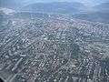 Aerial view of Žilina
People
- AYA (band)
- Zuzana Babiaková
- Pavol Bajza
- Peter Baláž
- Tomáš Bezdeda (born 1985, here), singer
- Jakab Cseszneky de Csesznek et Visk, medieval magnate
- Martin Dúbravka
- Martin Ďurica
- Ľubomír Feldek (born 1936, here), Slovak poet
- Ján Franek (born 1960, here)
- Ľudovít Fulla
- Stanislav Griga (born 1961, here), football coach
- Ladislav Hecht
- Tomáš Hubočan
- Peter Hoferica
- Miroslav Hýll
- Juraj Jánošík, Slovak national hero
- Karol Križan, ice hockey player
- Dušan Kuciak
- Martin Kuciak
- Branislav Labant
- Gwido Langer
- Dávid Leimdörfer, rabbi and author
- Vladimír Leitner
- Ján Mikolaj
- Marek Mintál, football (soccer) player
- Emil Pažický
- Peter Pekarík, football player
- Ronald Petrovický, ice hockey player
- Branislav Rzeszoto
- Dárius Rusnák
- Peter Sagan, cyclist
- Juraj Sagan, cyclist
- Michael Kolář, cyclist
- Ján Slota
- Ľuboš Šoška
- Peter Šoška
- Martin Šulík, actor
- Miroslav Šustek, writer
- Viktor Tausk, psychoanalyst
- Jozef Vengloš
- Radoslav Židek, snowboarder, the first Slovak medal winner at the Winter Olympic Games
Twin towns - Sister cities
Žilina has several twin towns around the world:[20]
References
Notes
- 1 2 Štefánik, Martin; Lukačka, Ján, eds. (2010). Lexikón stredovekých miest na Slovensku [Lexicon of Medieval Towns in Slovakia] (PDF) (in Slovak). Bratislava: Historický ústav SAV. p. 577. ISBN 978-80-89396-11-5.
- ↑ Krško, Jaromír (2011). Hydronymia horného povodia Váhu [Hydronymy of the Upper Váh Basin] (in Slovak). Banská Bystrica: Univerzita Mateja Bela. p. 125.
- ↑ Monumenta Hungariae historica
- ↑ Kirschbaum, Stanislav J. (1995). A history of Slovakia : the struggle for survival. New York: St. Martin’s Press.
- 1 2 "Municipal Statistics". Statistical Office of the Slovak republic. Archived from the original on 2007-12-17. Retrieved 2007-12-23.
- ↑ "Monthly Averages for Žilina, Slovakia". MSN. Retrieved 18 January 2008.
- ↑ "Railway Gazette: Rail Automation Business Unit opens". Retrieved 2010-10-31.
- ↑ Spectacular Slovakia 2004: Žilina and Northern Slovakia, the Malá Fatra mountains
- ↑ "Tourist information office Žilina". Tikzilina.eu. Retrieved 2013-03-12.
- ↑ "What to see in Zilina". Slovakiatravels.com. Retrieved 2013-03-12.
- ↑ "Church of St. Stephen the King / Kostol Sv. Štefana krála (Zilina, Slovakia) - Medieval Churches on". Waymarking.com. Retrieved 2013-03-12.
- ↑ "Členovia Mestského zastupiteľstva" (in Slovak). Retrieved 2007-12-23.
- ↑ Brusis, Martin (2002). "Between EU Requirements, Competitive Politics, and National Traditions: Re-creating Regions in the Accession Countries of Central and Eastern Europe". Governance. 15 (4): 531–559. doi:10.1111/1468-0491.00200.
- ↑ "Žilinská univerzita" (PDF) (in Slovak). Ústav informácií a prognóz školstva. Retrieved 2008-02-15.
- 1 2 "Prehľad základných škôl v školskom roku 2006/2007" (PDF) (in Slovak). Ústav informácií a prognóz školstva. 2006. Retrieved 2008-02-15.
- ↑ "Prehľad gymnázií v školskom roku 2006/2007" (PDF) (in Slovak). Ústav informácií a prognóz školstva. Retrieved 2008-02-15.
- ↑ "Prehľad stredných odborných škôl v školskom roku 2006/2007" (PDF) (in Slovak). Ústav informácií a prognóz školstva. Retrieved 2008-02-15.
- ↑ "Prehľad združených stredných škôl v školskom roku 2006/2007" (PDF) (in Slovak). Ústav informácií a prognóz školstva. Retrieved 2008-02-15.
- ↑ "Prehľad stredných odborných učilíšť a učilíšť v školskom roku 2006/2007" (PDF) (in Slovak). Ústav informácií a prognóz školstva. Retrieved 2008-02-15.
- ↑ "Žilina - oficiálne stránky mesta: Partnerské mestá Žiliny [Žilina: Official Partner Cities]". © 2008 MaM Multimedia, s.r.o.. Retrieved 2008-12-11.
- ↑ "Bielsko-Biała - Partner Cities". © 2008 Urzędu Miejskiego w Bielsku-Białej. Retrieved 2008-12-10.
External links
| Wikivoyage has a travel guide for Žilina. |
- Official website
- DPMZ - Public Transport Official Site
- Map & information system of Zilina
- Mesto v ktorom žijeme a nieje nám ľahostajné
| Wikimedia Commons has media related to Žilina. |