Zgornja Radovna
| Zgornja Radovna | |
|---|---|
 Zgornja Radovna Location in Slovenia | |
| Coordinates: 46°25′52.3″N 13°55′44.77″E / 46.431194°N 13.9291028°ECoordinates: 46°25′52.3″N 13°55′44.77″E / 46.431194°N 13.9291028°E | |
| Country |
|
| Traditional region | Upper Carniola |
| Statistical region | Upper Carniola |
| Municipality | Kranjska Gora |
| Elevation | 786.8 m (2,581.4 ft) |
| Population (2002) | |
| • Total | 67 |
| [1] | |
Zgornja Radovna (pronounced [ˈzɡoːɾnja ˈɾaːdɔu̯na]) is a dispersed settlement in the Municipality of Kranjska Gora, northwestern Slovenia, traditionally belonging to the Upper Carniola region. The village lies at the juncture of the Kot Valley and the northern part of the Krma Valley (i.e. the Lower Krma Valley - Slovene: Spodnja Krma). The Radovna River, a tributary of the Sava Dolinka, emerges under the Jutrova Skala Slope (Jutrova skala) in the northeastern part of the settlement.
Pocar Farm
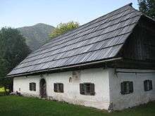
The Pocar Farm (Pocarjeva domačija) in Zgornja Radovna is one of the oldest traditional farmhouses in Triglav National Park, with the date 1775 engraved on one of its beams and a written document from 1672. It is one of the best preserved examples of the traditional 18th-century Alpine architecture and has been protected as a cultural monument of national significance. The farm now hosts an ethnographic museum and an information point of Triglav National Park.[2]
References
- ↑ Statistical Office of the Republic of Slovenia Archived November 18, 2008, at the Wayback Machine.
- ↑ Batista, Eva. "Pocarjeva domačija" [Pocar Farm]. DEDI - enciklopedija naravne in kulturne dediščine na Slovenskem (in Slovenian). Retrieved 13 June 2015.
External links
 Media related to Zgornja Radovna at Wikimedia Commons
- Zgornja Radovna at Geopedia
| Settlements | Administrative centre: Kranjska Gora
|  | ||||||
|---|---|---|---|---|---|---|---|---|
| Landmarks |
| |||||||
| Notable people | ||||||||