Zell am See
| Zell am See | ||
|---|---|---|
|
View over Lake Zell | ||
| ||
 Zell am See Location within Austria | ||
| Coordinates: 47°19′N 12°48′E / 47.317°N 12.800°ECoordinates: 47°19′N 12°48′E / 47.317°N 12.800°E | ||
| Country | Austria | |
| State | Salzburg | |
| District | Zell am See | |
| Government | ||
| • Mayor | Peter Padourek (ÖVP) | |
| Area | ||
| • Total | 55.17 km2 (21.30 sq mi) | |
| Elevation | 750 m (2,460 ft) | |
| Population (1 January 2016)[1] | ||
| • Total | 9,764 | |
| • Density | 180/km2 (460/sq mi) | |
| Time zone | CET (UTC+1) | |
| • Summer (DST) | CEST (UTC+2) | |
| Postal codes | 5700, 5702, 5705 | |
| Area code | 06542 | |
| Vehicle registration | ZE | |
| Website | www.zellamsee.salzburg.at | |


Zell am See is the administrative capital of the Zell am See District in the Austrian state of Salzburg. The town is an important tourist destination known as Zell am See-Kaprun and is a transportation hub for the region.
Geography
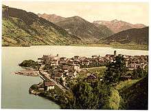
The Zell Valley is a corridor in the Kitzbühel Alps, connecting the Saalfelden Basin of the Saalach River in the north and the Salzach in the south. Zell am See is located approximately 100 km (62 mi) east of Innsbruck and 30 km (19 mi) north of Mt. Grossglockner. The Old Town (Altstadt) centre of Zell am See is located on the western shore of 68-metre (223 ft) deep Lake Zell, with the villages of Thumersbach to the east, Erlberg to the southeast, and Schüttdorf directly to the south.
Subdivisions
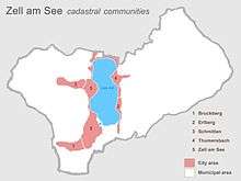
The town of Zell am See comprises five cadastral communities:
- Bruckberg, a residential area including the Zellermoos locality
- Erlberg on the southeastern shore of Lake Zell, including a nature reserve
- Schmitten, above Zell am See proper, location of many cableways
- Thumersbach, an affluent district and seaside resort on the eastern shore, including the summer resort of Prielau in the north
- Zell am See, with the Old Town centre and Zell am See-Süd (Schüttdorf)
Landscape
The original Lake Zell reached somewhat further to the north and extended south to the Salzach river. The dimensions of the lake, however, have changed over time into marsh areas. The lake has the shape of a peanut, with an area of 4.7 square kilometres (1.8 sq mi).

The mountains of the area form a horseshoe shape, the slopes are mainly forested or covered with Alpine pastures. The Hausberg ("home mountain") of Zell am See is the Schmittenhöhe, 1,965 m (6,447 ft), which together with the adjacent Salzburg Slate Alps range in the west is part of the Greywacke zone between Northern Limestone and Central Eastern Alps. Mt. Schmittenhöhe is a popular centre for skiing and winter sports. The nearby Mt. Hundstein ("Dog Stone") at 2,117 metres (6,946 ft) is the highest peak of the Salzburg Greywacke Zone.
Skiing
Zell am See provides winter skiing on the above Schmittenhöhe Mountain, the skiable area is approximately 138 km including the pistes on the Kitzsteinhorn and kaprun maiskogel. The ski pass covers the whole area including transport to and from the glacier which is open most of the year snow dependent. Zell am See is a low altitude ski area and snow cover can suffer from the temperature but the glacier has snow cover most of the year.
History
The area of Zell am See was continuously populated at least since Roman times. About 740 AD, by order of Bishop Johannes (John) I of Salzburg, monks founded the village within the stem duchy of Bavaria, which was mentioned as Cella in Bisonzio in a 743 deed. The denotation Cella or German: Zelle refers to a monk's cell in the sense of a monastery, Bisonzio is the name of the Pinzgau region. Zell received the rights of a market town in 1357. During the German Peasants' War in 1526, the area was site of heavy fighting against the troops of Swabian League. The Zell am See citizens had not participated in the uprising, nevertheless 200 years later, numeorus Protestant inhabitants were expelled from Salzburg by order of Prince-Archbishop Count Leopold Anton von Firmian.
From 1800, the town was occupied by French troops during the Napoleonic Wars. After the secularisation of the Salzburg Archbishopric, "Zell am See" finally passed to the Austrian Empire by resolution of the Vienna Congress in 1816. When in 1850 neighbouring Saalfelden became the capital of the Pinzgau district, the town's mayor successfully strived for relocating the administrative seat to Zell. The town's development was decisively promoted by the opening of the Salzburg-Tyrol Railway line (Giselabahn) on 30 July 1875, starting the annual summer tourism season. Zell am See received city rights on 24 January 24, 1928.


Timeline
- 1879, 15 July - Opening of the Hotel "Elisabeth"
- 1881 - Start of steam navigation with boat "Elisabeth" on the lake
- 1885 - Empress Elisabeth (Sissi) visits the Schmittenhöhe (mountain)
- 1887 - The municipality takes over ship navigation on Lake Zell
- 1893 - Visit of the Austrian Emperor Franz Josef I
- 1894 - The Grand Hotel is built
- 1898 - Business start of the Pinzgau Local Railway (Pinzgauer Lokalbahn)
- 1906 - Foundation of the Zell am See Skiing Club; first winter sports festival
- 1906 and 1910 - Acquisition of electric motor boats, end of steamship navigation
- 1914 - Railway double tracked
- 1924 - A light plane lands on the frozen Lake Zell
- 1928 - Construction of the tennis courts (used for ice-skating and ice-hockey in winter)
- 1928, January 25 - Commissioning of the Schmittenhöhebahn (up to the Schmitten mountain)
- 1928 - Foundation of a chapter of the Austrian Aeronautical Association (Österr. Flugtechnischer Verein)
- 1930 - Opening of the Hauptschule (similar to a UK secondary modern school)
- 1937, February 5 - Academic World Wintergames
- 1945 - City serves as a base for Company "E" of the 2nd Battalion, 506th Parachute Infantry Regiment (PIR), 101st Airborne Division.
- 1952, May 8 - Opening of the Alpine Gliding School
- 1959, May 15 - Opening of Zell Airport
- 1961 - Zell receives the status of a climatic spa
- 1966 - Serious damage caused by thunderstorms; the River Schmitten overflows its banks
- 1968 - Construction of the Spa and Sport Center and foundation of the Europe Sport Region
- 1973 - Ski-World Cup (12 to 20 December)
- 1975 - Rosenberg Castle (16th century) becomes the town hall
- 1976 - Opening of the new hospital
- 1977 - Commissioning of the one-rope chairlift "Zeller Bergbahn"
- 1979 - opening of the pedestrian area
- 1979 - Women's Down-hill World Cup
- 1981 - Honorary citizen: Dr.h.c.Ferdinand Porsche
- 1981 - Honorary citizen: Commercial Council Dr.h.c. Louise Piech-Porsche
- 1996 - Opening of the road tunnel (Schmitten Tunnel, 5,110 m)
- 2000 - Award ceremony of the Sydney Olympic winners Steinacher and Hagara (Tornado-Sailing)
- 2004 - Award ceremony of the Athens Olympic winners Steinacher and Hagara (Tornado-Sailing)
- 2005 - Naming of the third ship on Lake Zell, the "Schmittenhöhe"
- 2008 - World Hockey Tournament: see http://www.worldclass-hockey.com/Austria.htm
- 2012 - Zell am See and Kaprun host the IRONMAN 70.3 Zell am See-Kaprun triathlon for the first time
- 2015 - Zell am See and Kaprun host the IRONMAN 70.3 World Championship, which is held outside US & Canada for the first time
(Source: Custos Cav. H. Scholz)
Attractions
St. Hippolyte's Church
.JPG)
Within St. Hippolyte's Church are the oldest known building remnants of the Pinzgau region. The church is built in a mostly Romanesque style and consists of three naves. Before 1794, the central nave was crowned with a Gothic vault, but in that year it was replaced with another vault, which in turn was replaced by a flat wooden roof in 1898. Four steps lead up to the main altar, but the crypt has been filled in. The narthex and aisles are still Gothic, but some of the other Gothic objects (like the neogothic altars by Josef Bachlehner) were added during the renovation in 1898, when also the baroque furnishings of preceding centuries were removed.
The highpoint of the church is its elevated walkway with its ornate parapet, built in 1514. The walkway rests on four carved columns of precious marble, in between which an intricate net-vault is spun. The three pointed arches are crowned with crockets, and end in pointed towers. Between the arches are Gothic baldachins with cut-out figures of St. Hippolyte and St. Florian, originating from 1520.
.JPG)
The tower is the main focus of the Zell am See skyline. It has a height of 36 metres (118 ft). The strong walls have a limestone exterior.
From 1660 until 1670, the main altar was replaced by a Baroque one, which was removed again in 1760. Almost none of the Baroque furnishings of the church remain apart from some adornments. Two Baroque statues ended up in the church of Prielau. Next to the main altar are two statues dating from 1480: St. Rupert and St. Vigilius. The side altar contains an image of the Virgin Mary from the now non-existent Church of Maria Wald, which dates from 1540. The left nave has a small altar dedicated to St. Sebastian in its apsis.
The Grand Hotel Zell am See is situated in a unique position on a private peninsula right at the shore of Lake Zell - this large chalet is surrounded by water with a panoramic view of the mountains.
The Porsche family farm is located in Zell am See, having been obtained in 1939 by the senior Ferdinand Porsche in anticipation of the war. During the war, he transferred some of his business operations here and to Gmund, away from Stuttgart where, notwithstanding the heavy bombing, his son Ferry Porsche remained to oversee plant operations.
Education
In Zell am See there are 3 elementary schools, one high school, one special school, one vocational school, one grammar school, one commercial academy and a commercial school:
- Volksschule Zell am See
- Volksschule Schüttdorf
- Volksschule Thumersbach
- Hauptschule Zell am See
- Allgemeine Sonderschule
- Polytechnische Schule Zell am See
- Landesberufsschule Zell am See
- Bundesgymnasium und Bundesrealgymnasium Zell am See
- Bundeshandelsakademie und Bundeshandelsschule
Film shootings in Zell am See
- 1944/45: Film Ein Mann gehört ins Haus directed by Hubert Marischka.
- 1963: Film Allotria in Zell am See directed by Franz Marischka.
- 2001: Film Band of Brothers (TV miniseries) Part Ten - Points, directed by Mikael Salomon, executive producers Steven Spielberg and Tom Hanks.
See also
| Wikimedia Commons has media related to Zell am See. |