Zeelandic Flanders
| Zeeuws-Vlaanderen | ||
|---|---|---|
| Region | ||
| ||
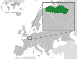
 Location of Zeelandic Flanders in Zeeland, Netherlands | ||
| Country | Netherlands | |
| Province | Zeeland | |
| Municipalities |
Sluis Terneuzen Hulst | |
| Area | ||
| • Land | 733.19 km2 (283.09 sq mi) | |
| • Water | 142.61 km2 (55.06 sq mi) | |
| Population (31-12-2010) | 106.522 | |
| Major roads | N58, N60, N61, N62 (Western Scheldt Tunnel) | |

Zeelandic Flanders (Dutch: Zeeuws-Vlaanderen [ˌzeːu̯sˈflaːndərə(n)],[1] Zeelandic: Zeêuws-Vlaonderen) is the southernmost region of the province of Zeeland in the south-western Netherlands. It lies south of the Western Scheldt that separates the region from the remainder of Zeeland to the north. Zeelandic Flanders is bordered to the south by Belgium.
Geography
Zeelandic Flanders is the north-eastern part of the large historical region of Flanders which today lies mostly in Belgium. It shares a land border with the Belgian provinces of East and West Flanders. It is a latitudinally oriented strip of land along the Western Scheldt, a North Sea estuary, and has no land access to the rest of the Netherlands. The area of Zeelandic Netherlands is 876 km2 (338 sq mi) of which 733 km2 (283 sq mi) is land and 143 km2 (55 sq mi) is water.
The region is bordered by the Zwin nature reserve in the West and the Drowned Land of Saeftinghe in the East.
Since local government boundary reforms in 2003, Zeelandic Flanders has consisted of only three municipalities: Sluis in the west, Terneuzen in the centre and Hulst in the east.
Transport
Zeelandic Flanders is connected to Flushing on Walcheren to the north of the Western Scheldt by the Western Scheldt Tunnel and the ferry it replaced which is now for pedestrians and cyclists. A ferry that formerly ran from Perkpolder to Kruiningen in South Beveland was discontinued upon opening of the tunnel.
The Ghent-Terneuzen Canal passes through Zeelandic Flanders.
A railway line which is only for goods trains links Terneuzen to Gent-Dampoort railway station.
History
Except for some formerly insular areas, the region now called Zeelandic Flanders was not part of the historical County of Zeeland, but a part of the County of Flanders initially ruled by the House of Habsburg. The region was front line in the Eighty Years' War and was conquered by the Dutch Republic in 1604. As such, it was the only part of Flanders, which took part in the insurgency, to become part of the new republic.
Zeelandic Flanders was subsequently ruled directly by the Dutch States General (parliament) as one of the Generality Lands and called Flanders of the States (Staats-Vlaanderen). After occupation by the French in 1795, the area accrued to the département of Escaut. Before the formation of the United Kingdom of the Netherlands in 1815, Zeelandic Flanders was territory of the Dutch province of North Brabant for a few years, but when the present province Zeeland was formed Zeelandic Flanders became a part of it, even after the 1830 Belgian Revolution that separated the remainder of Dutch Flanders from the Netherlands.
Population
As of 2010, the population of Zeelandic Flanders was 106,522 with 145 per square kilometre (380/sq mi).
Language
The native dialect of the western part of the region is Zeelandic Flemish, a variety of West Flemish. In the central regions, the Land-van-Axels and Land-van-Cadzands dialects of Zeelandic, itself a transition between West Flemish and Hollandic, are spoken. In the eastern part, East Flemish with some Brabantian influence is spoken. Because some smaller areas were isolated by water, and thus being small islands there are some dialects that differ slightly with the 'normal' dialect. This way, some villages have their own dialect, which people from the provinces above the 'big rivers' (the Waal and the Lek) cannot understand. The provinces above the big rivers include the provinces of North-Holland, South-Holland, Utrecht and Gelderland.
Notable people
- Lodewijk van den Berg, astronaut
- Willem Beukelszoon, inventor of gibbing
- Dick Dees, politician
- Jan Eekhout, author
- Jacques Hamelink, author and poet
- Willem van Hanegem, football player and coach
- Ate de Jong, director
- Annabel Kosten, swimmer
- Theo Middelkamp, professional cyclist
- Roelof Nelissen, politician and banker
- Jos de Putter, director
- Sandra Roelofs, First lady of Georgia (spouse of president Mikheil Saakashvili)
- Paul Tingen, schrijver, journalist, musician
- Kees Torn, comedian
- Herman Wijffels, Dutch administrator of the World Bank in Washington
See also
References
- ↑ Vlaanderen in isolation: [ˈvlaːndərə(n)].
| Wikimedia Commons has media related to Zeelandic Flanders. |
Coordinates: 51°20′N 3°49′E / 51.333°N 3.817°E
| Territories |
|  | ||||||||||
|---|---|---|---|---|---|---|---|---|---|---|---|---|
| ||||||||||||
| Politics | ||||||||||||
Symbols and history | ||||||||||||
| Other topics | ||||||||||||