Zapopan
| Zapopan | |||
|---|---|---|---|
| City & Municipality | |||
|
Municipal Palace of Zapopan (City Hall) | |||
| |||
.png) Location of the municipality in Jalisco | |||
|
Zapopan Location in Mexico | |||
| Coordinates: 20°43′13″N 103°23′31″W / 20.72028°N 103.39194°W | |||
| Country |
| ||
| State | Jalisco | ||
| Founded | 1541 | ||
| Municipal Status | 1825 | ||
| Government | |||
| • Municipal President | Pablo Lemus | ||
| Area | |||
| • Municipality | 893.15 km2 (344.85 sq mi) | ||
| Elevation (of seat) | 1,571 m (5,154 ft) | ||
| Population (2005) Municipality | |||
| • Municipality | 1,155,790 | ||
| • Seat | 1,026,492 | ||
| • Seat density | 1,035/km2 (2,680/sq mi) | ||
| Time zone | CST (UTC−6) | ||
| • Summer (DST) | CDT (UTC−5) | ||
| Postal code (of seat) | 45010 | ||
| Area code(s) | 33 | ||
| Demonym | Zapopano | ||
| Website | (Spanish) Municipal official site | ||

Zapopan (Spanish pronunciation: [saˈpopan]) is a city and municipality located in the Mexican state of Jalisco. Part of the Guadalajara Metropolitan Area, the population of Zapopan city proper makes it the second largest city in the state, very close behind the population of Guadalajara proper. It is best known as being the home of the Virgin of Zapopan, an image of the Virgin Mary which was made in the 16th century. This image has been credited with a number of miracles and has been recognized by popes and even visited by Pope John Paul II.[1] The municipality is also the home of the Centro Cultural Universitario, which contains one of the most important concert venues in Latin America[2] and is the home of the new stadium for the C.D. Guadalajara.[3]
The name Zapopan comes from the Nahuatl word “tzapotl” which means among sapote trees and the word “pan” which means among under.[1] It also has the nickname of “Villa Exmaicera” (ex-corn village), as it used to be a major producer of corn.[2] Its seal was designed by José Trinidad Laris in 1941 for the 400th anniversary of the city’s founding.[1]
History
From 1160 to 1325 a large number of Zapotec, Nahua and Maya families migrated into this area from the south, with many settling in the Profundo Arroyo area. These first settlers eventually mixed among themselves and with newcomers such as Aztecs and eventually were known as Tecos. Many small shrines called “cues” were built here, mostly to worship the sun, although the primary deity was a god-child called Teopiltzintli or the corn god.[1]
By the time the Spanish arrived Tzapopan was a fairly large settlement, but it was in decline due to wars with various surrounding nomadic tribes. It was subject to the dominion of Atemajac, also called Tlatoanazgo, which itself was subject to the Hueytlatoanazgo of Tonalá.[1]
In 1530, this area was subdued by Nuño de Guzmán, but the establishment of a Spanish settlement of Zapopan did not happen until 1541 due to the Mixtón War. In that year Francisco de Bobadilla, encomendero of Tlatltenango moved 130 Indians from his lands to repopulate Zapopan. Accompanying them was an image of Our Lady of the Conception, which had traveled to areas like Zacatecas as part of evangelization efforts. This statue would eventually take on the name of Our Lady of Zapopan. The sanctuary for this image was begun in 1689.[1]
In 1824, Zapopan was named at the seat of one of the 26 department of the newly created state of Jalisco. When the departments were reorganized in 1837, it retained its status as seat. In 1873, General Ramon Corona fought against rebel forces led by Manuel Lozada “El Tigre de Alica” at Rancho de la Mojonera.[1]
In 1991, the town gained city status in a ceremony that took place on 8 December, the 450th anniversary of the city’s foundation.[1]
In 1979, Pope John Paul II visited the Basilica of Our Lady of Zapopan.[1]
The city
Basilica of Zapopan and Virgin of Zapopan

The Virgin of Zapopan is an image of Our Lady of the Conception which was made in Michoacán by native artisans in the early 16th century.[2] The statue is 34 cm tall and made with corn stalks (caña de maiz), except for her hands which are made of wood. It was donated for evangelization efforts by Antonio de Segova, and carried to Zapopan by Miguel de Bolonia, who had the image tied to his body. Legend credits it with bringing an end to the Mixtón War in the 16th century as well as relief from epidemics that plagued Guadalajara in the 17th century, a “miracle” that was affirmed by the bishop of the area. It was named the “General” (La Generela) of the Army of the Three Guarantees in 1821, with the military title ratified in 1852 and 1894 by elements of the federal and state governments. It is still called by this alternate name. In 1919, it was crowned Queen of Jalisco by the Pope Benedict XV.[2][4]
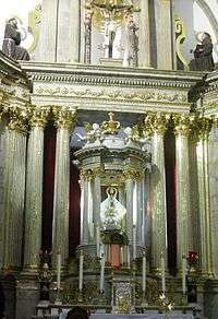
Construction of the Basilica of Zapopan began in 1689.[1] and finished in 1892.[5] It has been modified and expanded since then. In front of the structure is a large atrium. The atrium contains bronze statues of Antonio de Segovia, who donated the image of the Virgin in the 16th century and one of Pope John Paul II, with a child dressed as a charro, who represents Jalisco.[1] The facade is Plateresque[5] and the entrances have Ionic columns and coats of arms. The main altar is made of marble from Carrara and Cyprus with the image of the Virgin of Zapopan in a glass case at the top. Another important sculpture is that of the Holy Family, which has been in the church since 1832. It was sculpted by Victoriano Acuña.
In 1940 Pope Pius XII made the church a basilica.
Part of the basilica building is dedicated to the Huichol Museum. The museum is dedicated to the art and culture of the Huichol people as well as some displays from the Tepehuán and Cora peoples.[1] Another section of the basilica houses the Museum of the Virgin of Zapopan, where offerings left for the image can be seen, as well as items that have been used for its worship over the centuries.[5]
Annually, a large procession in this image’s honor takes place on the 12th of October, Columbus Day (called “Día de la Raza” (Day of the Race) in Spanish) .[1] This tradition started in 1734, when this image was named the patron of Guadalajara and the protector against epidemics, storms and other calamities.[5] Starting at 6 am, the image is carried on the streets from the Guadalajara Cathedral to the Basilica of Zapopan.[1] The streets, including the wide avenue of Manuel Avila Camacho in Zapopan proper, are packed with dancers, vendors selling traditional food and crafts and spectators.[4][5] The image stops periodically to receive homage from the many traditional dance groups and mariachi bands along the way. Traditional dances include “Los Tastoanes,” “La Danza del Águila Real,” “la de La Conquista” and “Los Huehuenches.”[1][4] Once returned to its home at the Basilica, celebrations continue and end with fireworks at night.[1]
Other landmarks
On Paseo Teopiltzintli, which was the main thoroughfare into the city, is the Arco de Ingreso a Zapopan (Entrance Arch), built by the Spanish founders of the city. It is made of quarried stone and is twenty meters high. The arch area is decorated with sculptures and the arch itself is topped with large jars and an eagle. The Paseo Teopiltzintli leads to the Plaza de las Americas, after passing the Plaza Civica.[1][5]
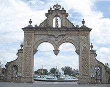
The Plaza de las Américas—Juan Pablo II Square is located in on the eastern side of the Basilica of Zapopan. It is paved with pink quarried stone, and contains a stone kiosk and four large fountains. There are two large sculptures in bronze depicting the god and goddess of corn, done by Juan Méndez. A statue of John Paul II is located here also.[1][5]
The main walking corridor of the city is Andador 20 de Noviembre, which is lined with galleries, bars, and restaurants. On Saturdays, artists and antique dealers display their wares for sale on the walkway.[5]

The Municipal Palace was constructed in 1942 as a school. It became the seat of the municipal government in 1968, and has been remodeled several times since.[1] The facade is decorated with reliefs.[5] The building’s staircase contains a mural called “La Revolución Universal” (The Universal Revolution) done by Guadalajara artist Guillermo Chavez Vega in 1970. This mural depicts scenes from the French, Industrial, English, Mexican and Socialist Revolutions. It also contains images of indigenous art.[1] The Plaza Civica or Civic Plaza is in front of the municipal palace, with a 7 metres (23 ft) flagpole and a bronze sculpture of the Mexican themed eagle devouring a serpent.[5]
The Municipal Cultural Center, built in 1979, holds exhibitions of fine art as well as theatrical and dance events. Next to it is the Plaza del Arte (Art Plaza) which is decorated with arches and columns of quarried stone and three permanent sculptures. The main mural of the building is entitled “La Historia de la Villa y la Revolución Mexicana” (The story of the village and the Mexican Revolution) painted in 1980 by Ricardo Peña. It also contains twenty three other murals done by art students over the years.[1]

The new Estadio Omnilife football stadium of the Guadalajara's club C.D. Guadalajara is next to the Bosque de la Primavera, in the northwestern Guadalajara Metropolitan area, just off the Anillo Periferico ring road and Avenida Vallarta in Zapopan. The stadium covers 147,000 square metres (1,580,000 sq ft) and has seating for over 45,000 people.[3]
The Neoclassical style Temple of San Pedro Apóstol was finished at the end of the 19th century. The atrium has a balustrade, and contains two large crosses with reliefs carved on them. The facade of the church is made of quarried stone with buttresses that flank the portal and side walls. Inside is a sculpture of Saint Peter, done by J. Cruz de la Mora in 1931, who was a native of Zapopan. The church also contains a painting from the 17th century done by Juan Correa called “The Baptism of Jesus.”[1]
The Centro Cultural Universitario is an ongoing project among the University of Guadalajara, the Municipality of Zapopan, the state of Jalisco, and the federal government to create a major cultural venue in western Mexico. The main structure is the Auditorio Telmex, an important concert venue in Latin America. There is also the Foro Alterno (Alternate Forum) which seats 15,000 people.[5] The project was begun in 2001, and other institutions located here include the Juan José Arreola State Library of Jalisco, the Conjunto de Artes Escenicas (Scenic Arts Complex), and the Environmental Science Museum.[6]
Other cultural venues in the city are the:
Galerías Theater, inaugurated in 1991 and the site of modern musicals, concerts, cultural festivals, and conventions.
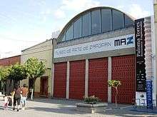
Museo de Arte de Zapopan (Zapopan Art Museum) presents permanent and temporary exhibitions as well as workshops. It is located in front of the Plaza Civica.[5]
Museo de Cacería Albarrán (Albarrán Hunting Museum) has a Sudanese style facade. In this museum are three halls which exhibit 270 hunting trophies from many parts of the world, some of which are the full animals but most are heads. The building is of modern design and the collection belonged to Benito Albarrán, a renowned game hunter.[1]
Zapopum
The Zapopum Festival started out as the municipal fair of Zapopan in 2005. However, since then, it has morphed into a major cultural event for the city. It aims to be “a cultural reference point, whose purpose is to spread culture and bring it to the public who is accustomed to other types of shows.” The 2009 event featured acrobats and circus acts from countries such as Spain, England, Germany and Italy. Some of these were “Alicia en los cielos” y the Spanish group Puja!, “Cupidos” and “Esferas” by Australian group Strange Fruit and performances by French mime Jerôme Murat. There are also workshops, themed pavilions and shows by popular Mexican artists such as Marco Antonio Muñiz, Gloria Trevi and Ricardo Montaner. The event has attracted as many as 800,000 people in past years.[7]
The municipality


As municipal seat, the city of Zapopan is the local government for approximately 750 other communities, called localities,[8] which together form a territory of 893.15km2.[1] Almost 90% of the municipality’s population lives in the city proper.[8] Zapopan is the second most populous municipality in the state of Jalisco and ranks seventh in Mexico. Aside from the seat, the most important localities are Nuevo México, San Francisco Tesistán, Valle Real, La Venta del Astillero, La Magdalena (San José Ejidal), Nextipac, Ciudad Bugambilias, Base Aérea Militar de la XV Zona, San Esteban (San Miguel Tateposco) .[2] This municipality is bordered by the municipalities of Tequila, San Cristóbal de la Barranca, Tlajomulco de Zuñiga, Tlaquepaque, Guadalajara, Ixtlahuacán del Río, Tala, Arenal and Amatitlán.[1]
Most of the municipality is flat with another quarter having rolling hills. Altitude varies from 1,500 to 2,000 meters above sea level. The main elevations are in the Sierra de la Primavera and include Nejahuete, Tajo and El Chapulin. Superficial water flows mostly in arroyos east to the Grande or Santiago River. In the center of the municipality there are three dams called the Copalita, the Santa Lucia and the San Jose. Winters here are mild and usually are noticeable only in the higher elevations. Average year-round temperature is 22C with highs of 36C and lows of 11C. Rain principally falls from June to October. Vegetation in the municipality varies from pines and holm oaks in the Sierra de la Primavera and species such as jonote (Heliocarpus appendiculatus), strawberry trees and nopals in the lower elevations. While wildlife has nearly disappeared from this area,[2] the Bosque el Nixticuil on the northern edge of the urban sprawl has been designated as a protected natural area[9] and still is home to many mammals, reptiles, amphibians, birds and insects.[10]
| Climate data for Zapopan (1951–2010) | |||||||||||||
|---|---|---|---|---|---|---|---|---|---|---|---|---|---|
| Month | Jan | Feb | Mar | Apr | May | Jun | Jul | Aug | Sep | Oct | Nov | Dec | Year |
| Record high °C (°F) | 36.0 (96.8) |
39.0 (102.2) |
40.5 (104.9) |
42.0 (107.6) |
41.0 (105.8) |
41.0 (105.8) |
36.5 (97.7) |
38.5 (101.3) |
37.0 (98.6) |
39.0 (102.2) |
39.0 (102.2) |
39.0 (102.2) |
42.0 (107.6) |
| Average high °C (°F) | 25.1 (77.2) |
27.3 (81.1) |
29.9 (85.8) |
32.3 (90.1) |
33.5 (92.3) |
31.1 (88) |
27.8 (82) |
27.8 (82) |
27.6 (81.7) |
27.5 (81.5) |
26.6 (79.9) |
25.0 (77) |
28.5 (83.3) |
| Daily mean °C (°F) | 16.8 (62.2) |
18.4 (65.1) |
20.4 (68.7) |
22.6 (72.7) |
24.2 (75.6) |
23.6 (74.5) |
21.8 (71.2) |
21.8 (71.2) |
21.7 (71.1) |
20.7 (69.3) |
18.7 (65.7) |
17.0 (62.6) |
20.6 (69.1) |
| Average low °C (°F) | 8.4 (47.1) |
9.5 (49.1) |
10.8 (51.4) |
13.0 (55.4) |
15.0 (59) |
16.1 (61) |
15.8 (60.4) |
15.7 (60.3) |
15.7 (60.3) |
14.0 (57.2) |
10.8 (51.4) |
9.0 (48.2) |
12.8 (55) |
| Record low °C (°F) | −4.0 (24.8) |
−2.0 (28.4) |
1.0 (33.8) |
1.0 (33.8) |
7.0 (44.6) |
7.0 (44.6) |
7.0 (44.6) |
6.0 (42.8) |
8.0 (46.4) |
7.0 (44.6) |
1.0 (33.8) |
−7.0 (19.4) |
−7.0 (19.4) |
| Average precipitation mm (inches) | 15.1 (0.594) |
10.0 (0.394) |
4.5 (0.177) |
4.2 (0.165) |
23.0 (0.906) |
195.5 (7.697) |
264.1 (10.398) |
217.8 (8.575) |
163.8 (6.449) |
60.4 (2.378) |
13.5 (0.531) |
12.1 (0.476) |
984.0 (38.74) |
| Average precipitation days (≥ 0.1 mm) | 2.1 | 1.1 | 0.5 | 1.0 | 3.1 | 14.2 | 20.0 | 18.7 | 14.1 | 6.2 | 1.6 | 2.1 | 84.7 |
| Source: Servicio Meteorológico Nacional[11][12] | |||||||||||||
About three-quarters of the municipality’s land is used for agriculture and livestock. About fifteen percent is forested and the remaining is dedicated to the city of Zapopan.[2] The principle crops are corn, sorghum, squash, tomatoes, chickpeas, avocados, mangos and plums. Some livestock such as cattle, pigs and domestic fowl are raised. Agriculture employs less than three percent of the population. About a third of the population is employed in industry and manufacturing. Major companies that have facilities here include Kodak, Motorola and Coca Cola. The rest of the population is involved in commerce and services.[1]
Tourism is mostly focused on the Basilica of Zapopan and other local churches; however, outside the city there are a number of natural attractions such as Ixcatán Geysers and the La Cola de Caballo waterfall.[1] At the Santa Lucia dam one can fish and go out on rowboats. Cola de Caballo is a 150 meter tall waterfall which is part of the Blanco Arroyo. The Geysers of Ixcatan are geothermic zone with a number of geysers which jump out with a temperature of 45C up to five meters high. At Cerro del Diente are large rocks where mountain climbing, rock climbing and rappelling are practiced.The Barranca del Río Santiago, also known as the Barranca del Oblatos is a canyon which 3.5 km wide, 700 meters deep and 200 km long. The Bosque de la Primavera (Primavera Forest) covers 30,500 hectares over the Sierra de la Primavera. The forest area has both fresh water and thermal springs and varied plant and wildlife. There are a number of signaled hiking trails with signs pointing out interesting points and plants. Another forest in the municipality is the Bosque El Centinela, which is an area that was reforested in the late 1970s and has mountain biking paths and campgrounds.[5] A number of water parks such as Rio Caliente and La Primavera have been established.[1]
The municipality has three main archeological sites. Ixtépete contains a Teotihuacan style pyramid which is twenty meters long, sixteen meters wide and 1.83 meters high. Construction phases of this pyramid date back from the 5th century to the 10th century. El Grillo is located in the Tabachines housing subdivision in the north of the Valley of Atemajac. This site has a series of fourteen tombs arranged along an arroyo which is now dry. La Coronilla is located in an area called La Experiencia.[1] In and around the city of Zapopan, there have been finding of ancient tombs. One example is when about a dozen pre-Hispanic objects were found during a hydraulic work excavation at Ciudad Granja, in Zapopan, Jalisco. A pot, a vase and anthropomorphic figures are among the items discovered. These objects are of the Shaft Tombs Tradition which developed between 100 BCE and 500 CE in western Mexico. Further excavations are planned to search for a shaft tomb. The initial discovery was made by construction workers in May 2009 while doing maintenance work.[13]
The La Mojonera Ranch is the site of the confrontation between government forces under General Ramón Corona and rebels led by Manuel Lozada “El Tigre de Alicia” on 28 January 1873. The event is called the Battle of La Mojonera.[1]
Education
Universities
Universidad Panamericana, campus Guadalajara www.up.edu.mx;
Universidad Autonoma de Guadalajara
Instituto Tecnológico y de Estudios Superiores de Monterrey (ITESM) has its second biggest campus in the city.[14]
Primary and secondary schools
International schools include:
- Colegio Alemán de Guadalajara, a German international school[15]
- Lycée Français de Guadalajara, a French international school[16]
- Instituto Miguel Ángel de Occidente
Weekend supplementary education
The Colegio Japones de Guadalajara A.C. (グアダラハラ補習授業校 Guadarahara Hoshū Jugyō Kō), a part-time Japanese school, is in Zapopan.[17] It provides lessons during afternoons.[18]
Sister cities
International
 Częstochowa, Poland
 Grand Rapids, Michigan, USA
 Kiriat Bialik, Israel
 Marianao, Cuba
 Changwon, Republic of Korea
 Rosemead, California, USA
- Saginaw, Michigan, USA
Within Mexico
 Atengo, Jalisco
 Bahía de Banderas, Nayarit
- El Grullo, Jalisco
 Veracruz, Veracruz
- Zapotlán el Grande, Jalisco.[2]
References
- 1 2 3 4 5 6 7 8 9 10 11 12 13 14 15 16 17 18 19 20 21 22 23 24 25 26 27 28 29 30 "Enciclopedia de los Municipios de México Estado de Jalsico Zapopan" (in Spanish). Mexico: INAFED. Retrieved January 19, 2010.
- 1 2 3 4 5 6 7 8 "Breve historia del municipio de Zapopan" [Brief history of the municipality of Zapopan] (in Spanish). Zapopan, Mexico: Municipality of Zapopan. Retrieved January 19, 2010.
- 1 2 "Estadio Chivas" [Chivas Stadium] (in Spanish). Guadalajara, Mexico: Chivas Football Club. Retrieved January 19, 2010.
- 1 2 3 "Nuestra Señora de Zapopan, Jalisco" [Our Lady of Zapopan, Jalisco] (in Spanish). Mexico City: Mexico Desconocido. Retrieved January 19, 2010.
- 1 2 3 4 5 6 7 8 9 10 11 12 13 "Cosas por hacer" [Things to do] (in Spanish). Zapopan, Mexico: Municipality of Zapopan. Retrieved January 19, 2010.
- ↑ "Centro Cultural Universitario" [University Cultural Center] (in Spanish). Retrieved January 19, 2010.
- ↑ "Festival Cultural Zapopum" (in Spanish). Mexico: Mexico Desconocido magazine. Retrieved January 27, 2010.
- 1 2 "INEGI Census 2005" (in Spanish). Archived from the original on February 27, 2013. Retrieved January 19, 2010.
- ↑ Senado de la República - Gaceta Parlamentaria No. 116. 06/09/2005
- ↑ Exhorta al Ejecutivo Federal a Declarar como Área de Protección de Recursos Naturales al Bosque de El Nixticuil - Sitio Oficial Diputados Federales PAN Archived July 22, 2011, at the Wayback Machine.
- ↑ "NORMALES CLIMATOLÓGICAS 1951-2010" (in Spanish). Servicio Meteorológico Nacional. Retrieved February 21, 2013.
- ↑ "Extreme Temperatures and Precipitation for Zapopan 1941-2010" (in Spanish). Servicio Meteorológico Nacional. Retrieved February 21, 2013.
- ↑ "Prehispanic Objects Found in Zapopan". Mexico: INAH. Retrieved January 19, 2010.
- ↑ ""
- ↑ Home page. Colegio Alemán de Guadalajara. Retrieved on March 14, 2014. "Colegio Alemán de Guadalajara, A.C. Bosques de los Cedros 32. Fracc. Las Cañadas. C.P. 45132 Zapopan / Jalisco"
- ↑ Home page. Lycée Français de Guadalajara. Retrieved on 25 January 2015. "Francisco Villa 235. Colonia El Bajío. CP 45019. Zapopan, Jalisco. México"
- ↑ "中南米の補習授業校一覧(平成25年4月15日現在)" (Archived 2014-05-10 at WebCite). Ministry of Education, Culture, Sports, Science and Technology (MEXT). Retrieved on May 10, 2014.
- ↑ Carrillo Regalado, Salvador (サルバドール・カリージョ・レガラード), 岡部 拓, and 柿原 智弘. "日本直接投資のための地域的要因: メキシコ・ハリスコ州の事例" ( Archived 2015-04-13 at WebCite). In: 経済研究所研究報告 (Archived 2015-04-15 at WebCite) (2013). Seijo University. p. 31-92. Retrieved on April 14, 2015. English abstract available. p. 44 (PDF p. 14/12). "れた,平日午後に毎日授業のある世界で4つのみある準全日制の学校の一つである。教育目標として,確かな学力と,日本人としての感性を身につける児童生徒の育成,を掲げており,カリキュラムとして,幼稚園部:活動(日本語の維持向上,小学部入学に向けての生活態度の育成等),小学部:国語,算数,数学,生活,社会,理科,中学部:国語,数学,社会,理科,という日本の義務教育に相当する内容が実施されている。"
Coordinates: 20°43′N 103°24′W / 20.717°N 103.400°W
| Wikimedia Commons has media related to Zapopan. |