Chissioua Mtsamboro
.JPG)
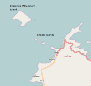
Chissioua Mtsamboro, widely known previously as Zamburu Island, also Saddle Island, is an island, about 3 miles off the northwest coast of Mayotte in the Indian Ocean in the Comoros archipelago.[1] It lies north of the Choazil Islands, just off the coast of Mtsamboro.[2][3]This stretch of water is known as the Zamburu Passage,[1] part of the Mozambique Channel.[4] Chissiou Mtsamboro is a mountainous island covering 2 square kilometres, providing shelter to the main stretch of beach, tucked away in the southwest of the island which contains a main settlement and numerous huts dotted along the beach. Its highest point reaches an altitude of 273 metres. The soundings close to the reef which surrounds the island is from 10 to 15 fathoms.[1]
References
- 1 2 3 Rosser, William Henry; Imray, James Frederick (1867). The seaman's guide to the navigation of the Indian Ocean and China Sea: including a description of the wind, storms, tides, currents, &c., sailing directions; a full account of all the islands; with notes on making passages during the different seasons. J. Imray & Son. p. 364. Retrieved 15 June 2011.
- ↑ Google Maps (Map). Google.
- ↑ United States. Hydrographic Office (1927). South Indian Ocean pilot: Islands westward of longitude 92 ̊east including Madagascar and the Comoro Islands. G.P.O. Retrieved 15 June 2011.
- ↑ United States. Hydrographic Office (1 January 1952). Publications. p. 157. Retrieved 15 June 2011.
Coordinates: 12°38′41″S 45°1′53″E / 12.64472°S 45.03139°E