Zalongo
| Zalongo Ζάλογγο | |
|---|---|
|
Monastery of Zalongo. | |
 Zalongo | |
|
Location within the regional unit 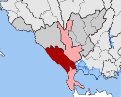 | |
| Coordinates: 39°08′N 20°40′E / 39.133°N 20.667°ECoordinates: 39°08′N 20°40′E / 39.133°N 20.667°E | |
| Country | Greece |
| Administrative region | Epirus |
| Regional unit | Preveza |
| Municipality | Preveza |
| • Municipal unit | 137.6 km2 (53.1 sq mi) |
| Population (2011)[1] | |
| • Municipal unit | 4,299 |
| • Municipal unit density | 31/km2 (81/sq mi) |
| Time zone | EET (UTC+2) |
| • Summer (DST) | EEST (UTC+3) |
| Vehicle registration | ΡΖ |
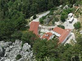
Zalongo (Greek: Ζάλογγο) is a former municipality in the Preveza regional unit, Epirus, Greece. Since the 2011 local government reform it is part of the municipality Preveza, of which it is a municipal unit.[2] The municipal unit has an area of 137.631 km2.[3] Population 4,299 (2011). The seat of the municipality was in Kanali. Nearby is the 18th century Zalongo Monastery, immortalized by the defiant mass suicide of a group of Souliot women. The ruins of ancient Cassope are situated near the village Kamarina.
References
- ↑ "Απογραφή Πληθυσμού - Κατοικιών 2011. ΜΟΝΙΜΟΣ Πληθυσμός" (in Greek). Hellenic Statistical Authority.
- ↑ Kallikratis law Greece Ministry of Interior (Greek)
- ↑ "Population & housing census 2001 (incl. area and average elevation)" (PDF) (in Greek). National Statistical Service of Greece.
| Wikimedia Commons has media related to Zalongo. |
This article is issued from Wikipedia - version of the 12/1/2016. The text is available under the Creative Commons Attribution/Share Alike but additional terms may apply for the media files.