Zaō Quasi-National Park
| Zaō Quasi-National Park | |
|---|---|
| 蔵王国定公園 | |
|
IUCN category V (protected landscape/seascape) | |
|
| |
 Map of Japan | |
| Location | Tōhoku, Japan |
| Coordinates | 38°05′28″N 140°26′24″E / 38.091°N 140.44°E[1]Coordinates: 38°05′28″N 140°26′24″E / 38.091°N 140.44°E[2] |
| Area | 396.35 km2 (153.03 sq mi) |
| Established | 8 August 1963 |
| Governing body | Miyagi Prefecture and Yamagata Prefecture |
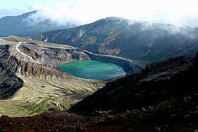
Zaō Quasi-National Park (蔵王国定公園 Zaō Kokutei Kōen) is a Quasi-National Park that extends in the Ou Mountains between Miyagi and Yamagata Prefectures, Japan. Established in 1963, the central feature of the park is Mount Zaō.[3][4][5]It is rated a protected landscape (Category V) according to the IUCN. [6]
Like all quasi-national parks in Japan, the park is managed by the local prefectural governments, in this case, that of Yamagata and Miyagi prefectures.[7]
Related municipalities
See also
| Wikimedia Commons has media related to Zao Quasi-National Park. |
References
- Sutherland, Mary and Britton, Dorothy. The National Parks of Japan. Kodansha International (1995). ISBN 4-7700-1971-8
- ↑ "Zao Quasi National Park". protectedplanet.net.
- ↑ "Zao Quasi National Park". protectedplanet.net.
- ↑ "栗駒/南三陸金華山/蔵王/男鹿". National Parks Association of Japan. Retrieved 5 February 2012.
- ↑ "List of Quasi-National Parks" (PDF). Ministry of the Environment. Retrieved 5 February 2012.
- ↑ "Zaō Quasi-National Park". Miyagi Prefecture. Retrieved 5 February 2012.
- ↑ "Zao Quasi National Park". protectedplanet.net.
- ↑ "National Park systems: Definition of National Parks". National Parks of Japan. Ministry of the Environment of the Government of Japan. Retrieved 2008-08-29.
- ↑ "Designation of the Natural Parks of Miyagi Prefecture". Miyagi Prefecture. Retrieved 5 February 2012.
- ↑ "Natural Parks of Yamagata Prefecture" (PDF). Yamagata Prefecture. Retrieved 5 February 2012.
External links
- (Japanese) Map of Zaō Quasi-National Park
This article is issued from Wikipedia - version of the 11/18/2016. The text is available under the Creative Commons Attribution/Share Alike but additional terms may apply for the media files.