Yopal
| Yopal | |||
|---|---|---|---|
| Municipality and town | |||
|
Panorama view of Yopal, from La Iguana Natural Park (Parque Natural La Iguana) | |||
| |||
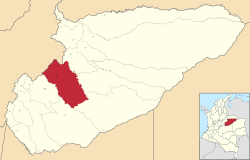 Location of the municipality and town of Yopal in the Casanare Department of Colombia. | |||
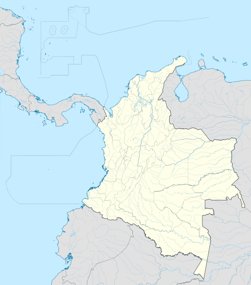 Yopal Location in Colombia | |||
| Coordinates: 5°21′0″N 72°24′36″W / 5.35000°N 72.41000°WCoordinates: 5°21′0″N 72°24′36″W / 5.35000°N 72.41000°W | |||
| Country |
| ||
| Region | Orinoquía Region | ||
| Department | Casanare Department | ||
| Founded | 1915 | ||
| Area | |||
| • Total | 2,771 km2 (1,070 sq mi) | ||
| Elevation | 350 m (1,150 ft) | ||
| Population (2012) | |||
| • Total | 118,484 | ||
| • Density | 43/km2 (110/sq mi) | ||
| Demonym(s) | Yopaleño | ||
| Time zone | Colombia Standard Time (UTC-05) | ||
| Postal code | 850001-9 | ||
| Area code(s) | 57 + 8 | ||
| Website | Official website (Spanish) | ||


Yopal is a municipality and capital city of the department of Casanare in Colombia.
Geographic information
- Population: 150 000 inhabitants
- Elevation: 350 m
- Extensión: 2,771 km²
- Distance from Bogotá: 387 km
- Median temperature: 26 °C

El Resurgimiento Park (Parque el Resurgimiento)

Yopal Municipal Church
Climate
| Climate data for Yopal | |||||||||||||
|---|---|---|---|---|---|---|---|---|---|---|---|---|---|
| Month | Jan | Feb | Mar | Apr | May | Jun | Jul | Aug | Sep | Oct | Nov | Dec | Year |
| Average high °C (°F) | 32.5 (90.5) |
33.2 (91.8) |
33.2 (91.8) |
31.5 (88.7) |
30.8 (87.4) |
29.7 (85.5) |
29.9 (85.8) |
30.5 (86.9) |
30.7 (87.3) |
30.8 (87.4) |
31.1 (88) |
31.7 (89.1) |
31.3 (88.35) |
| Average low °C (°F) | 22.5 (72.5) |
22.9 (73.2) |
23.7 (74.7) |
22.6 (72.7) |
22.3 (72.1) |
21.7 (71.1) |
21.5 (70.7) |
21.4 (70.5) |
21.5 (70.7) |
21.6 (70.9) |
21.9 (71.4) |
22.2 (72) |
22.15 (71.88) |
| Average rainfall mm (inches) | 8.5 (0.335) |
60.4 (2.378) |
79.3 (3.122) |
279.0 (10.984) |
333.7 (13.138) |
298.0 (11.732) |
312.3 (12.295) |
255.4 (10.055) |
275.9 (10.862) |
255.0 (10.039) |
131.8 (5.189) |
20.2 (0.795) |
2,309.5 (90.924) |
| Average rainy days (≥ 1 mm) | 1 | 4 | 7 | 15 | 16 | 17 | 18 | 17 | 15 | 14 | 10 | 4 | 138 |
| Source: IDEAM | |||||||||||||
Born in Yopal
- Jeffry Romero, professional cyclist
External links
- (Spanish) Yopal official website
- (Spanish) La Voz de Yopal (Radio)
Municipalities in the Casanare Department | ||
|---|---|---|
This article is issued from Wikipedia - version of the 6/24/2016. The text is available under the Creative Commons Attribution/Share Alike but additional terms may apply for the media files.