Yonaguni
| Native name: <span class="nickname" ">Dunan[1] | |
|---|---|
|
Map of Yonaguni
 Yonaguni Location of Yonaguni in Okinawa | |
| Geography | |
| Location | Pacific Ocean |
| Coordinates | 24°28′N 123°0′E / 24.467°N 123.000°E |
| Archipelago | Yaeyama Islands |
| Area | 28.91 km2 (11.16 sq mi) |
| Coastline | 27.5 km (17.09 mi) |
| Highest elevation | 231.4 m (759.2 ft) |
| Highest point | Urabu |
| Administration | |
| Town | Yonaguni |
| Demographics | |
| Population | 1,684 (2009) |
| Pop. density | 58.2 /km2 (150.7 /sq mi) |

Yonaguni (Japanese: 与那国島 Hepburn: Yonaguni-jima, Yonaguni romanization: Dunan, Okinawan romanization: Yunaguni) is one of the Yaeyama Islands. It is the westernmost inhabited island of Japan and lies 108 kilometers (67 mi) from the east coast of Taiwan, between the East China Sea and the Pacific Ocean proper.
Geography
The island has an area of 28.88 km2 (11.15 sq mi), a population around 1700, an annual mean air temperature of 23.9 °C, and annual precipitation of 3000 mm. All islands are under jurisdiction of the town of Yonaguni, Yaeyama Gun, Okinawa and there are three towns: Sonai, Kubura and Higawa.

Yonaguni, more specifically Cape Irizaki 24°26′58″N 122°56′01″E / 24.44944°N 122.93361°E at the western tip of the island, is the westernmost point of Japan. Taiwan is said to be visible from Irizaki on a clear day.
Climate
Yonaguni has a tropical rainforest climate (Köppen climate classification Af). The average yearly temperature is 23.8 °C (74.8 °F), and the average monthly temperature ranges from 18.4 °C (65.1 °F) in January to 28.8 °C (83.8 °F) in July. September is the wettest month while July is the driest.
| Climate data for Yonaguni | |||||||||||||
|---|---|---|---|---|---|---|---|---|---|---|---|---|---|
| Month | Jan | Feb | Mar | Apr | May | Jun | Jul | Aug | Sep | Oct | Nov | Dec | Year |
| Average high °C (°F) | 20.5 (68.9) |
21 (70) |
22.8 (73) |
25.2 (77.4) |
27.7 (81.9) |
29.8 (85.6) |
31.4 (88.5) |
31.2 (88.2) |
29.8 (85.6) |
27.6 (81.7) |
24.9 (76.8) |
21.9 (71.4) |
26.15 (79.08) |
| Daily mean °C (°F) | 18.4 (65.1) |
18.8 (65.8) |
20.4 (68.7) |
22.9 (73.2) |
25.3 (77.5) |
27.5 (81.5) |
28.8 (83.8) |
28.5 (83.3) |
27.3 (81.1) |
25.4 (77.7) |
22.8 (73) |
19.8 (67.6) |
23.83 (74.86) |
| Average low °C (°F) | 16.4 (61.5) |
16.8 (62.2) |
18.3 (64.9) |
20.8 (69.4) |
23.2 (73.8) |
25.6 (78.1) |
26.6 (79.9) |
26.2 (79.2) |
25.1 (77.2) |
23.5 (74.3) |
20.9 (69.6) |
17.9 (64.2) |
21.77 (71.19) |
| Average precipitation mm (inches) | 198.8 (7.827) |
157.9 (6.217) |
152.1 (5.988) |
173.3 (6.823) |
207.4 (8.165) |
164.0 (6.457) |
138.5 (5.453) |
212.5 (8.366) |
293.2 (11.543) |
227.7 (8.965) |
248.3 (9.776) |
179.7 (7.075) |
2,353.4 (92.655) |
| Average relative humidity (%) | 74 | 77 | 78 | 79 | 81 | 83 | 80 | 81 | 79 | 75 | 74 | 72 | 77.8 |
| Mean monthly sunshine hours | 55.7 | 57.2 | 82.4 | 99.5 | 140.1 | 182.1 | 258.9 | 229.3 | 182.5 | 136.9 | 85.9 | 64.7 | 1,575.2 |
| Source: JMA (1981-2010) [2] | |||||||||||||
History
In the 15th century, it was incorporated into the Ryūkyū Kingdom.[3] By 1879, the island was formally annexed into Japan.
Until the early 20th century, Yonaguni was part of the larger Yaeyama Magiri (village after 1907), which included the neighboring Yaeyama Islands. In 1948, it became an independent village. From 1945 to 1972, it was occupied by the United States and was then returned to Japan to form a part of Okinawa Prefecture.
On May 4, 1998, a part of the island was destroyed by a submarine earthquake.
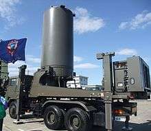
As a result of increased tensions between Japan and China over the disputed sovereignty of the Japanese-controlled uninhabited Senkaku/Diaoyu/Tiaoyutai Islands which are located roughly 80 nautical miles north-northeast of Yonaguni Island, Japan began construction in 2014 of a coastal monitoring/early warning station with radar and other sensors on Yonaguni to counter a perceived threat from Chinese forces.[4][5] The initial planned complement of a 150 troops include personnel stationed at a physically separate garrison camp located on the outskirts of Yonaguni town.[6] The station's radar became active on March 28, 2016.[7] Separately, a joint (GSDF/ASDF) “mobile aircraft control & warning squadron" is planned to be formed and co-located at the station.
Notable features
Yonaguni is known in Japan for the hanazake, a 120-proof rice-based distilled beverage (awamori) produced only on the island.
The island is also the only natural habitat of a distinctive horse breed, the Yonaguni horse.
Yonaguni is a popular attraction for divers because of the large numbers of hammerhead sharks that gather in the surrounding waters during winter.
Yonaguni Monument
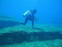
In 1986, local divers discovered a striking underwater rock formation off the southernmost point of the island. The formation, known popularly as the Yonaguni Monument, has staircase-like terraces with flat sides and sharp corners. Although the majority of the academic society regard the rock formation as natural joint, Masaaki Kimura, a professor of seismology in University of the Ryukyus and some media believe it is an artificial (or artificially modified) structure engraved or built 2,000 to 3,000 years ago.[8]
Patrick D. Nunn, Professor of Oceanic Geoscience at the University of the South Pacific, has studied these structures extensively and notes that the structures below the water continue above and are slate that "has been fashioned solely by natural processes" and that "there seems no reason to suppose that they are artificial."[9]
Transportation
Yonaguni Airport serves Yonaguni island.
Television
Yonaguni was the filming location for Fuji TV's drama series, Dr. Kotō Shinryōjo (Dr.コトー診療所 / Dr. Koto's Clinic) which aired between 2003-2006. A fictional Chinese naval incursion into Yonaguni's territorial waters and the ensuing military standoff was a plot point of the second season of House of Cards (S2E10).
See also
References
- ↑ Alexander Vovin (2010). Korea-Japonica: A Re-Evaluation of a Common Genetic Origin. University of Hawaii Press. p. 43. ISBN 978-0-8248-3278-0.
- ↑ "Yonagunijima Climate Normals 1981-2010" (in Japanese). Japan Meteorological Agency. Retrieved February 5, 2014.
- ↑ Kerr, George H. (2000). Okinawa: the History of an Island People. (revised ed.) Boston: Tuttle Publishing.
- ↑ Tiezzi, Shannon (18 April 2014). "Japan to Station Troops on Yonaguni, Near Disputed Islands". thediplomat.com. The Diplomat. Retrieved 18 April 2014.
- ↑ "Japan wary of China military threat." Archived June 25, 2008, at the Wayback Machine. Al Jazeera, 17 December 2010.
- ↑ "Yonaguni votes in favor of GSDF deployment on island". the-japan-news.com. The Yomiuri Shimbun. 23 February 2015. Retrieved 23 February 2015.
- ↑ "Japan opens radar station close to disputed isles, drawing angry China response". reuters.com. Reuters News Service. 28 March 2016. Retrieved 29 March 2016.
- ↑ "Yonaguni, Japan". New Scientist (2736). 2009-11-25. Retrieved 2010-07-06.
- ↑ Nunn, Patrick D. Vanished Islands and Hidden Continents of the Pacific University of Hawaii Press (15 Aug 2008)ISBN 978-0824832193 p.127
External links
Coordinates: 24°27′N 122°59′E / 24.450°N 122.983°E